I'm sure that readers of this blog understand this, perhaps leaving only those who do not WANT to understand.
This is what most people point to when they claim that a blue sea event is impossible (or unlikely).
What folk misunderstand is that although the sea ice extent is tying with the 2012 melt year conditions are COMPLETELY DIFFERENT. Note, the above defines sea ice extent as the "area of ocean with at least 15 per cent ice. What that means is you could have ice that is 6 inches thick and it is defined as "sea ice extent". This is far - removed from 2012 when there was plenty of ice that was several meters thick. When the ice is in such a condition the sea ice extent data can go up and down like a yo-yo but this is not really a predictor of what might happen. Have a look at the data below from the US Navy site.
There are now NO areas where the sea ice concentration is at 100%- and it has changed quickly, as shown by the .gif.
Particularly alarming, the following shows that ice in the Central Arctic Basin is between 0.5 and 1 metre thick and the tiny area of thicker ice, north of Greenland is only 2 meters thick. Now, that old ice has completely disappeared.
Here you can see the rapid changes over 30 days. Notice the area of very thin ice close to the North Pole.
And another source of data on ice concentration
It is difficult to say in these conditions what might transpire during the remaining weeks of sunlight (and beyond) but those people who are claiming to know whether there might be a BOE or not do not know what they are talking about. Finally, this video from CNN is in equal parts information and propaganda. What it does (while completely overlooking sea ice because it has a far more short-term effect on the climate than the Greenland ice sheet. They are correctly panicking over the rapid rate of melt which could happen over a lifetime while they ignore a phenomenon that could bring very rapid changes (as in months and years, not decades). That does not fit into their narrative (see the second half of the video). They do, however, acknowledge, perhaps for the first time, the role of the much warmer waters in melting ice far more rapidly than the mainstream ever contemplated.
Scientists find troubling signs under Greenland glacier
Underwater
glacial melting is happening up to 100 times faster than previously
thought, a major study has found.
For
the first time, researchers directly measured the melting of
tidewater glaciers below the waterline.
They
found existing models were “wildly inaccurate”.
Study
co-author Rebecca Jackson, of Rutgers University-New Brunswick in the
US, said: “We found that melt rates are significantly higher than
expected across the whole underwater face of the glacier – in some
places 100 times higher than theory would predict.”
Until
now, scientists did not know how fast these glaciers – which are
found in Greenland, Alaska and Antarctica – were melting under the
surface.
Researchers
previously used water and air temperature, as well as ocean currents,
to measure the melt speed.
But
the latest study, published in the journal Science,
found that ocean salinity and the shape of the glacier was also
important.
“We
have opened the door to correcting these models and allowing other
researchers to use our method to explore other tidewater glaciers
around the world," lead researcher Dr David Sutherland told The
Independent.
LeConte Glacier,
which flows into LeConte Bay (NOAA)
The
oceanographer, from the University of Oregon, added that his
team's data “provides a new constraint for improving
those models and points to the ocean as an important trigger for ice
loss”.
Scientists
studied the underwater melting of LeConte Glacier, which flows into
LeConte Bay in south Juneau in Alaska between 2016 and 2018.
They
used sonar to scan and profile the underwater face of the glacier.
They also measured the speed of currents, temperature and salinity of
the meltwater flow.
Iceberg
calving was detected using time-lapse photography, and weather
station data measured surface melt. The team believe
their approach could be used to study melting rates at other types of
glaciers.
This
latest study adds to research that suggests assumptions about
underwater melting at glaciers need to be revisited – because of
the alarming effects of the phenomenon on rising sea levels.
Dr
Sutherland added: “Future sea-level rise is primarily determined by
how much ice is stored in these ice sheets. We are focusing on the
ocean-ice interfaces because that’s where the extra melt and ice is
coming from that controls how fast ice is lost.
“To
improve the modelling, we have to know more about where melting
occurs and the feedbacks involved.”
New
Zealand's glaciers have experienced a "huge loss" of ice in
little more than four decades, under a trend only worsening with
climate change.
A
new paper, led by climate scientist Professor Jim Salinger, showed a
third of the country's glaciers had melted and flowed into rivers
since the late 1970s.
It
comes as another global study, out today, reveals glaciers here and
worldwide have been having a larger impact on sea level rise than
scientists first thought.
As
glaciers were extremely sensitive to shifts in temperature,
scientists regarded them as useful coalmine canaries for climate
change.
This is the paper by Jim Salinger cited in the article
Some of the southern region's smaller glaciers have disappeared, following two of the hottest summers on record.
The discovery was made by Niwa climate scientists and glaciologists last month, during the annual long-term aerial Snowline Survey of the South Island's glaciers.
Niwa scientists take to the skies every March to record the snowline altitude of up to 50 glaciers, using specialised cameras from a light aircraft, reports Otago Daily Times.
Thousands of photos are taken from different angles to build 3-D models of glaciers that can be compared year on year, to give an accurate depiction of how much of the previous winter's snow remains to contribute to long-term glacial ice accumulation.
The information gathered over the past four decades has produced a unique and valuable data set that provides an independent measure of how climate change and variability are affecting New Zealand's water resources.
Although Niwa scientists are still piecing together data from the latest survey, project leader Andrew Lorrey said it was not hard to miss the fact that some of the smaller glaciers at lower altitudes had now disappeared.
"It's really sad to see that some of our smaller glaciers - particularly on the fringes of the Southern Alps, that are a little bit lower in altitude like North Canterbury and as you go south out of Queenstown - are reducing to nothing.
"There's no reason for me to go to Caroline Peak [near Lake Hauroko] anymore.
"There used to be a snow patch and glacier on the spine of that peak, and based on what we saw last year, there was no real reason for us to go back there this year. There probably wouldn't have been much of anything left there."
He said a glacier on Mt Wilson in North Canterbury was also gone.
"It's now down to two very small snow packs, or remnant glacial pieces, that are like the size of a couple of dining room tables.
"It's looking pretty grim.
"One of the pilots said, `There's no need to come back here anymore'. And he's right.
"There's not really anything we can tell from those glaciers anymore because they're gone."
Dr Lorrey said it was the sad reality of the changing climate of the region.
"For anyone who says global warming is a farce, I would say let's have this conversation in front of a disappearing glacier in New Zealand.
"It's very hard to argue against physical evidence like this, where these glaciers are so acutely attuned to what's going on with temperature.
"The fact that they are disappearing, and they are largely driven by fluctuations in our temperature, speaks volumes about what's going on."
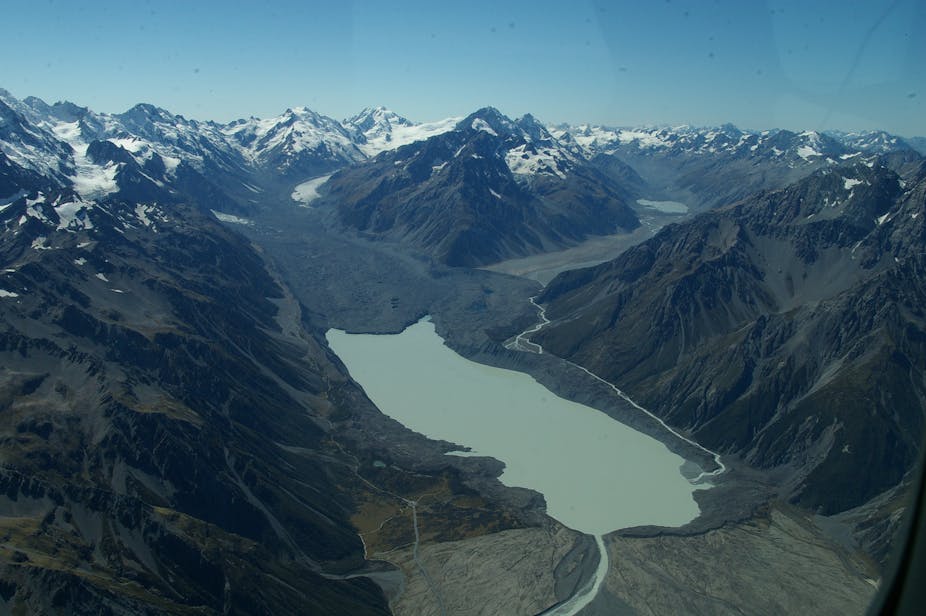
Photos
have emerged of huge chunks of ice which have broken off the Tasman
Glacier.
The
photos were posted to Facebook by two local guides who were alerted
to the event in the Aoraki/Mount Cook National Park early
on Wednesday morning.
"Glacier
Explorers called us about the event so we got there after they had
cleaned up some of the chaos," Anthony Harris, a guide at
Southern Alps Guiding, said.
Large
chunks of ice have come off the Tasman Glacier on the South Island's
west coast.
"Luckily
the kayaks were racked and above the height of the waterline."
A
tidal surge up to 2 metres high smashed the jetty about and lifted a
boat trailer upside down onto another trailer, Harris said.
The
process is known as glacial calving.
"All
in all, this is the most significant event I've seen in the last five
years on the Tasman.
"The
present SE [southeasterly] is holding these bergs in the northern
section of the lake and will do so for at least another day or two.
"Once
we get a NW [northwester] they will begin to fill the lake with bergs
of all sizes ... some of these are really big."
Glaciologist
Heather Purdie says large calving events happen about once every two
years at the Tasman Glacier.
The
breaking of ice chunks from the edge of glaciers is known as glacial
calving.
University
of Canterbury glaciologist Heather Purdie said large calving
events like this one happened about once every two years on the
Tasman Glacier.
They
were caused by glacial ice above the water melting, putting
pressure on the ice beneath it still under the water.
The
photos were taken by two guides who operate in the area.
When
the pressure became too much, the ice eventually snapped off.
"The
water gets in underneath the ice and sort of jacks it up, and it
snaps off.
"Large
calving events are less frequent but the icebergs that come up are
really big."
The
calving was caused by ice above the water melting, putting pressure
on ice still under the water.
The
calving was not necessarily the result of global warming, although
the glacier retreating and becoming smaller was attributable to
warming, Purdie said.
"Not necessarily because of global warming". Yeah, right! This is from last year
NZ
glaciers shrank significantly in hot summer The
summer heatwave has massively affected New Zealand's glaciers,
resulting in the largest annual ice loss on record.
The
meltback was observed by the annual Glacier Snowline Survey, a
collaboration between NIWA and Victoria University.
Survey
founder Trevor Chinn said it was one of the largest glacier meltbacks
since he began the survey in 1977.
"A
glacier is the best climate change indicator you can use," he
said.
New
Zealand glaciers have lost 30 percent of their ice, in the 40 years
that the annual snowline survey has been running.
Whether
these dramatic results could be directly attributed to climate change
"is the $64,000 question", Niwa climate scientist Andrew
Lorrey said.
Niwa
said it was embarking on formal testing in collaboration with
Victoria University and the University of Melbourne to see if a
definitive correlation could be found.
"Can
you actually get a natural event like this, or is it something where
climate change has loaded the dice and it's pushed us over some sort
of threshold?" Dr Lorrey said.
"Those
are the questions we're looking to answer."
Global warming predicted to melt massive Himalayan glaciers, disrupt food production
The Khumbu Glacier in Nepal, pictured in 2009, is one of the Himalayan glaciers threatened by global warming, a new report suggests. (Photo: ICIMOD/ALEX TREADWAY HANDOUT, EPA-EFE)
Antarctica and Greenland aren't the Earth's only frozen places threatened by human-caused climate change: The Himalayas are also at risk, scientists announced Monday.
In fact, a whopping two-thirds of Himalayan glaciers could melt by 2100 if global warming continues, according to the new report.
Such a catastrophic melt would disrupt the flow of Asian rivers, which are a crucial resource for crops for billions of people in China, India and six other countries.
"This is the climate crisis you haven't heard of," said Philippus Wester, a scientist with the International Centre for Integrated Mountain Development, which released the report. “Global warming is on track to transform the frigid, glacier-covered mountain peaks ... to bare rocks in a little less than a century," he said in a statement.
The glaciers are now a critical source of water for about 250 million people in the mountains and an additional 1.65 billion others who live in the river valleys below, the report said.
Water from the melting glacial ice could lead to floods along such major rivers as the Ganges and the Indus, potentially destroying crops.
According to the report, the region is known as the world’s “Third Pole” for its huge store of ice, and it is also home to Mount Everest, K2 and other iconic peaks
Prepared over a five-year period with contributions from more than 350 researchers, the report is the first "to lay down in definitive detail the region’s critical importance to the well-being of billions and its alarming vulnerability, especially in the face of climate change,” said David Molden, director general of the development group that published the study.
Though the mountains are tens of millions of years old, their glaciers are extremely sensitive to the changing climate. Since the 1970s, when global warming first set in, these huge masses of ice have steadily thinned and retreated.
Man-made climate change, aka global warming, is caused by the burning of fossil fuels such as gas, coal and oil, which release greenhouse gases such as carbon dioxide (CO2) and methane into the atmosphere. This extra CO2 causes temperatures of the atmosphere and oceans to rise to levels that can't be explained by natural causes.
In addition to the warming effects from those invisible greenhouse gases, the area is also plagued by punishing levels of air pollution. Black carbon and dust pollution can exacerbate and amplify the effects of greenhouse gases, further accelerating ice melt, the report said.
The polluted air also changes monsoon and rainfall patterns all across Asia.
Besides China and India, the other six most threatened Asian nations are Afghanistan, Bangladesh, Bhutan, Myanmar, Nepal and Pakistan.
“We need to start thinking of mountain regions as climate hotspots worthy of urgent attention, investments and solutions,” concluded Dasho Rinzin Dorji of Bhutan, a board member of the International Centre for Integrated Mountain Development.
The Lirung Glacier is 37 miles northwest of Kathmandu, Nepal. Two-thirds of Himalayan glaciers could melt by 2100 if global emissions are not reduced, scientists warned in a major study released Feb. 4, 2019. (Photo: SAM TAYLOR, AFP/Getty Images)
“The
1890s extent of ice volume in New Zealand’s Southern Alps was 170
km3, compared to 36.1 km3 now. That disappearance of 75-80% of
Southern Alps ice is graphic evidence of the local effects of global
warming”
It is a matter of shame that there has been so little in New Zealand media (count on the fingers of ONE hand) on the demise of ice in the Southern Alps in New Zealand and the rapid retreat of our main glaciers.
About a week ago Radio NZ featured the following interview with Dave Bamford, a lifelong mountain climber. It was unscheduled and labelled by "Nghts Sport" (there are no details as to what is being discussed in the interview, and yet it gave one of the best first-person accounts of what is happening to our Alps.
Judging from what Dave is saying it would be hard to find a climate sceptic amongst the climbing fraternity because they have to live with the consequences.
Already many places have become unaccessible and passes over the mountains are in essence closed because of the danger of landslides from the collapse of the morraine wall on the sides of the ice river.
Listen to the interview. It is worth your time.
Mountaineer, Dave Bamford , describes the rapid retreat of New Zealand's glaciers
Listen to the interview here.
You can see 2 years of glacier retreat illiustrated here.
It is a matter of considerable shame that I have to report that some of the main reporting on this has been in the foreign media.
This piece of research was carried by Australia's the Conversation and not by New Zealand media.
The largely bare Southern Alps at the end of summer, 2018.
A
NASA satellite photo of the Southern Alps, stretching along New
Zealand’s South Island, shown here capped with snow in
2002.Jacques
Descloitres/NASA/Wikimedia Commons
Since
1977, the Southern Alps’ ice volume has shrunk by 18.4 km3 or
34%, and those ice losses have been accelerating rapidly in the past
15 years.
The
story of the Southern Alps’s disappearing ice has been very
dramatic – and when lined up with rapid glacier retreats in many
parts of the world, raises serious questions about future sea level
rise and coastal climate impacts.
The
Southern Alps’ total ice volume (solid line) and annual gains or
losses (bars) from 1976 to 2014 in km3 of water equivalent, as
calculated from the end-of-summer-snowline monitoring programme.
Glaciers are large-scale, highly
sensitive climate instruments, which in an ideal world we would pick
up and weigh once a year, because their fluctuations provide one of
the clearest signals of climate change. A glacier is simply the
surplus ice that collects above the permanent snowline where the
losses to summer melting are less than the gains from winter
accumulation. A glacier flows downhill and crosses the permanent
snowline from the area of snow gain to the zone of ice loss. The
altitude of this permanent snowline is the equilibrium line: it marks
the altitude at which snow gain (accumulation) is exactly balanced by
melt (ablation) and is represented by the end-of-summer snowline.
<image id=Authors, CC
BY
In
1977, one of us (Trevor Chinn) commenced aerial photography to
measure the annual end-of-summer snowline for 50 index glaciers
throughout the Southern Alps.
These
annual end-of-summer surveys have been continued
by the National Institute of Water and Atmospheric Research (NIWA).
We then use the NIWA results to calculate the annual glacier mass
balance and hence volume changes of small to medium sized glaciers in
the Southern Alps. Small to medium glaciers respond quickly to annual
variability of weather and climate, and are in balance with the
current climate.
Not
so the twelve largest glaciers: the Tasman, Godley, Murchison,
Classen, Mueller, Hooker, Ramsay, Volta/Therma, La Perouse, Balfour,
Grey, and Maud glaciers. These have a thick layer of insulating rocks
on top of the ice lower down the glaciers trunk. Their response to
new snow at the top is subdued, and take many decades to respond.
Up
until the 1970s, their surfaces lowered like sinking lids maintaining
their original areas. Thereafter, glacial lakes have formed and they
have undergone rapid retreat and ice loss.
The
Rolleston index glacier in the Southern Alps of New Zealand, showing
the accumulation area where fresh clean snow gain occurs above the
end-of-summer snowline, and the area of melting ice below. Here, a
negative balance year in 2009 shows a higher end-of-summer snowline
revealing underlying old snow.Trevor
Chinn, CC
BY
To
come up with our calculations, we have used the snowline survey data
plus earlier topographic maps and a GPS survey of the ice levels of
the largest glaciers to calculate total ice-volume changes for the
Southern Alps up until 2014.
Over
that time, ice volume had decreased 34%, from 54.5 km3 to
36.1 km3 in water
equivalents. Of that reduction, 40% was from the 12 largest glaciers,
and 60% from the small- to medium-sized glaciers.
These
New Zealand results mirror trends from mountain glaciers globally.
From 1961 to 2005, the thickness of “small” glaciers worldwide
decreased approximately 12 metres, the equivalent of more than 9,000
km3 of water.
Global
Glacier Thickness Change: This shows average annual and cumulative
glacier thickness change of mountain glaciers of the world, measured
in vertical metres, for the period 1961 to 2005.Mark
Dyurgerov, Institute of Arctic and Alpine Research, University of
Colorado, Boulder, CC
BY
Martin
Hoelzle and associates at the
World Glacier Monitoring Service have estimatedestimate
the 1890s extent of ice volume in New Zealand’s Southern Alps was
170 km3,
compared to 36.1 km3 now.
That disappearance of 75-80% of Southern Alps ice is graphic evidence
of the local effects of global warming.
Further
large losses of ice in the Southern Alps have been projected by
glaciologists Valentina Radic and Regine Hock, suggesting that only
7-12 km3 will
remain by the end of the 21st century. This is based on regional
warming projections of 1.5°C to 2.5°C. This represents a likely
devastation of ice cover of the Southern Alps over two centuries
because of global warming.
And
where does all this melted glacier ice go? Into the oceans, thus
making an important contribution to sea level rise, which poses a
serious risk to low-lying islands in the Pacific, and low-lying
coastal cities from Miami in the US to Christchurch in NZ.
But
a local tour operator, Fox Glacier Guiding, has been unable to take
tourists onto the ice on foot since April, when glacial retreat
caused a river to change course, blocking access to a popular hiking
trail. And at another glacier about 14 miles down the road, the
operator Franz Josef Glacier Guides lost hiking access in 2012, also
because of retreating ice.
Now,
air landings by helicopter are the only way to set foot on the
glaciers, which lie at the confluence of the Southern Alps and the
Tasman Sea on the west coast of New
Zealand’s
South Island. As a result, both companies have made helicopter tours
their primary product, increasing business for local
helicopter operator.
Finally, earlier this year the gap was filled by this article in stuff.co.nz


 Posts