Wildfire Smoke over North Pole — Web Cam Shows Melt Ponds Beneath Brown Carbon Haze
14
July, 2015
For
Alaska and Canada, as of today, an unprecedented 12,000,000 acres of
forest and tundra overlying the rapidly thawing and human greenhouse
gas emissions warmed permafrost has burned — going up in vast,
billowing clouds of smoke. This smoke has spread out, caught up in
the meandering Jet Stream, and is now visible in far-flung locations
by both ground and satellite observation.
In
addition to painting skies across Canada, Alaska and the Western and
Central US milky white, upper level smoke from the fires has crossed
Greenland and the North Atlantic, entered the Central Arctic Ocean
and is now visible as a hazy pall over web cameras observing North
Pole melt.
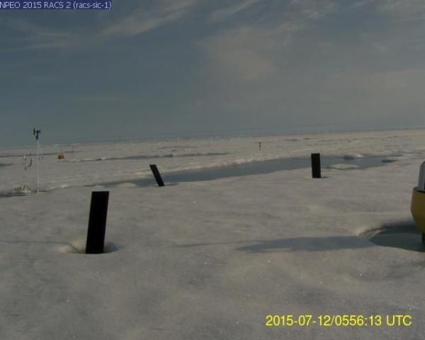
(Melt
ponds and teetering markers near North Pole web cam beneath skies
painted gray-brown by wildfire smoke. Image source: North
Pole Environmental Observatory.)
In
the above image we can see this smoke haze painting the sky a
brown-gray pallor in the NEOPAWS North Pole web cam image. Beneath
these skies, the sea ice surface has melted to the point that the
marker strakes are wobbling off kilter and that substantial melt
ponds are cutting deep furrows into the polar ice. The hazy hew of
skies in this image together with an overhead cirrus cloud cover
tinted brown indicates that smoke particles have been lofted into the
Jet Stream level.
Wildfire
Smoke over Sea Ice
Satellite
tracking of the smoke also confirms ground-based observations. For as
of July 6 a large bellow of smoke had wafted up from the
unprecedented wildfires burning in Alaska (now at 4.44 million acres
and climbing). Drawn up in a high amplitude Jet Stream wave this
smoke could clearly be seen traversing the Beaufort and Chukchi Seas
in the MODIS satellite shot:
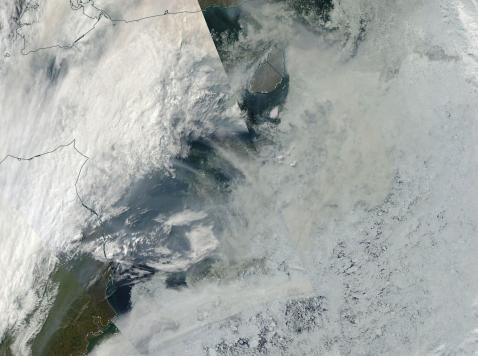
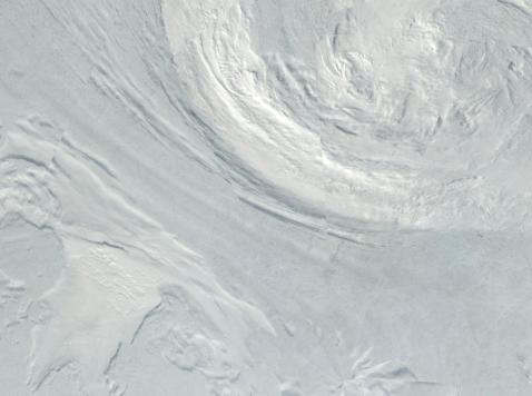
(Top
and bottom frame images tracking a plume of wildfire smoke emitting
from Alaska, crossing the Beaufort and Chukchi seas on July 7 and
entering the Central Arctic on July 12. Image source: LANCE
MODIS.)
By
Sunday, this smoke had become entrained in the draw between a
cyclonic circulation over the Laptev Sea and an anticyclone formation
on the Greenland side of the Arctic. It’s a dipole pattern that has
now lasted for more than a week. One that is regarded as rather
unhealthy for late season sea ice totals. Note the herring-bone
formation of darkened upper level clouds drawn through the dipole and
running diagonally from upper left frame to lower right of the second
image. The pole in image 2 is also in the lower right frame.
Conditions
in Context — Brown Carbon at Jet Stream Level is an Amplifying
Feedback
Lofting
large amounts of brown carbon into the Jet Stream level of the
atmosphere is an amplifying feedback to human-caused warming. One
occurring in addition to the added rate of carbon release generated
by these wildfires as well as to a transient negative feedback coming
from generating thick, low level clouds, that block out sunlight.
High
level clouds alone aid in the heating of the Earth — allowing
visible sunlight to penetrate while trapping long rave radiation
rebounding from the Earth’s surface. Painting these clouds dark
through brown carbon smoke particulate emission into the upper
atmosphere provides an added heat kick by further lowering cloud
albedo and by re-radiating an overall greater portion of the
transient heat. As a final insult, the brown carbon aloft eventually
precipitates down to the surface. When such precipitation lands on
ice sheets and northern hemisphere snow cover, it darkens the snow
and enhances melt. A kind of ominous global warming fallout.
Smokey
haze over North Pole melt ponds — one albedo reducing process being
reinforced by the other.
Links:
Hat
Tip to Colorado Bob
(Please
support non special interest based, publicly funded science, climate
change mitigation, renewable energy transition, and climate change
resiliency efforts)


No comments:
Post a Comment
Note: only a member of this blog may post a comment.