Possible Strongest El Nino on Record Gets Another Kick From Upper Ocean Heat
27
July, 2015
For
the month of July, El Nino crossed solidly into strong event
thresholds. Temperatures
in the key indicator Nino 3.4 region have continued to rise overall,
hitting 1.5 degrees Celsius above average during the first week of
the month, then hitting +1.7 and +1.6 C during the second and third
weeks.
Model consensus continues to show the heat building — hitting
around +2.1 C in the average by October, November and December.
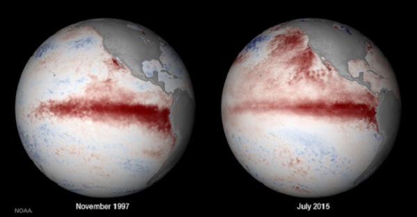
(A
NOAA comparison shows the 1997-1998 El Nino at peak heat during
November of 1997 [left frame]. The right frame image shows the
2014-2016 El Nino during its mid July ramp-up. Note the hot blob of
water off the US West Coast in the July 2015 image. Heat in this
region tends to drive an atmospheric feedback that continues to push
more warm water into the Eastern and Central Equatorial Pacific. Note
that, due to this and other factors, the 2014-2016 will likely also
hit a peak intensity during October or November. An intensity that
could exceed the monster 1997-1998 El Nino event. Image source: NOAA
Environmental Visualization Laboratory.)
So
much warming in this region of the Pacific would be enough to make
the 2014-2016 El Nino nearly as strong as the 1997-1998 event. But,
ominously, a few of our more trusted models show temperatures peaking
out at around +3 C for the Nino 3.4 zone. A level that would exceed
all previous thresholds for El Nino strength. It’s the kind of heat
pulse that would re-write the record books for strong El Ninos. The
kind that would enable global surface air temperatures — under the
constant and building pressure of an excessive human greenhouse gas
emission — to hit new and troubling record highs over the coming
months.
For
such a record event to happen, there needs to be a powerful plug of
heat just beneath the ocean surface. It needs to back up into the
Central Pacific and it needs to be intense enough to deliver the kind
of heat energy predicted. And all indications are that the available
heat energy for this potentially record event on the way.
A
Massive Plug of Upper Ocean Heat
Back
in March one of the strongest westerly wind outbreaks ever to occur
in the Western Pacific sent a powerful wave of heat rippling out
beneath the broadest section of equatorial ocean water in the world.
Hot water, driven to near record temperatures by a human-forced
warming of the atmosphere and ocean system spread out just below the
surface and began to up-well — contacting the airs just off the
West Coast of South America.
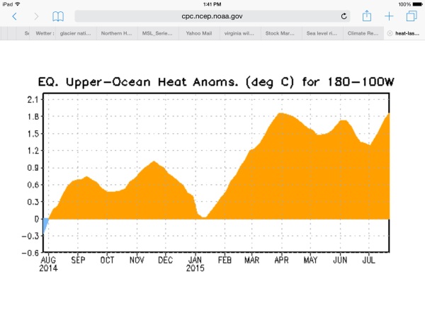
(Upper
ocean heat is again ramping above the 1.8 C positive anomaly mark for
the Equatorial Pacific. A sign that more surface warming is likely on
the way. Image source:NOAA
CPC.)
At
that time, the
NOAA measure of heat accumulated in the upper 400 meters of the
Equatorial Pacific,
showed temperatures had rocketed to 1.8 degrees Celsius above average
for the entire basin. Since then, a series of west wind outbreaks
have continued to pile abnormally warm water into the upper ocean
environment — keeping temperatures in the range of 1.1 to 1.8 C
above average.
Now,
due to a very long duration westerly wind outbreak that began during
late June and has extended for more than a month, upper ocean heat
content is again on the rise. As of last week, it had rocketed again
to 1.8 degrees Celsius above average for the basin. And signs
indicated there was at least a moderate potential for continued
strengthening of this heat pulse. Observational data and GFS model
runs show a continuing westerly wind flow over the Western Pacific.
Winds circling around two lows parallel to one another and straddling
the Equator near 170 East are predicted to increase to near 25 to 35
mph over the next few days. It’s the most recent surge in this very
long duration westerly wind outbreak. One that will likely only
continue to drive more heat into the upper ocean environment.
(A
strong Kelvin Wave is now backing more and more heat into the Nino
3.4 zone. In watching the progress of upper ocean heat in this
visualization, we could be witnessing the final stages of an event
that will go down in the record books. Image source: NOAA
CPC)
Already,
we can see the strong, warm Kelvin Wave — which has been a
persistent feature since mid March — becoming reinvigorated. The
Kelvin Wave is now rebounding away from coastal South America even as
its warm water zones expand. Its hottest waters are heading more
toward mid Ocean. A trend that, if forecast models prove correct,
will deliver serious heat to the middle Pacific sea surface region
this Fall.
It’s
a massive delivery of heat that we can now watch in slow motion. One
that could now be in the process of delivering one of the strongest,
if not the strongest El Nino in the history of record keeping for
this ocean warming event.
Links:


No comments:
Post a Comment
Note: only a member of this blog may post a comment.