Hot Ocean Hurls Nangka’s 1 Meter Rains At Japan; Storm Chases Arctic Heat Delivery Later This Week
This
week, a
screaming hot Pacific basin hurled six tropical cyclones northward.
16
July, 2015
These
cyclones spawned off the back of a building monster El Nino which is
predicted to reach strong-to-record intensity by later this
year. They
also contributed to setting a record for number of cyclones formed in
the Northern Hemisphere so early in the year.
In the Western Pacific, one of these Cyclones — Typhoon Chan Hom —
slammed into Shanghai on July 10th and 11th, delivering high waters,
high winds and floods.
Now,
another cyclone — Typhoon Nangka — is venting its fury on Japan.
A
few hours ago, Nangka
made landfall near Muroto City.
Over the past 24 hours, Nangka had weakened from a category 3 storm
packing 115 mile per hour intensity, blustering ashore as a minimal
Typhoon with 75 mile per hour maximum sustained winds. Nangka is
interacting with a frontal boundary, which interfered with the
storm’s circulation even as it injected massive amounts of moisture
into Nangka’s encircling thunderstorms. This increased moisture
loading — likely also enhanced by global temperatures that are now
in the range of 1 C hotter than 1880s averages together with moisture
bleeding off an anomalously warm Pacific — is resulting
in forecasts
for up to 1 meter of rainfall as
Nangka continues to churn over Japan.
Nangka’s
eyewall and strong south to north winds are running smack into
Japan’s ocean facing mountains. The combined high moisture loading
and the lifting action of winds running up the mountains are pumping
up Nangka’s thunderstorms to extraordinary intensity. Weather
radar from earlier today showed hourly rainfall rates peaking at an
extreme 3.15 inches per hour near Shikoku.
There, after hours of this intense pounding, rainfall
totals have hit as high as 23 inches (UPDATE: Kamikitayama village
had reported 27 inches of total rainfall as of 5:20 AM local time.)
These
heavy rains are expected to continue for the next 24-48 hours with
very severe additional totals predicted for a number of regions.
Expected new
rainfall amounts include:
- Kinki and Tōkai: 600 millimeters (~24 inches)
- Shikoku island: 600 millimeters (31 inches)
- Kantō region: 400 to 500 millimeters (16 to 20 inches)
- Chūgoku region: 300 to 450 millimeters (12 to 16 inches)
- Tōhoku region: 250 to 350 millimeters (10 to 14 inches)
Extraordinary
additional rains that will bring with them the risk of severe flash
flooding and landslides to the mountainous slopes of Japan.
Nangka
At Tail End of Warm, Wet Wind Invasion of Arctic Later This Week
As
Nangka continues northward, it will become wrapped up in a trough,
helping to feed a larger synoptic pattern of moisture and air flow
from south to north. The trough, in turn, is projected to rush
northward into the Bering Sea. By Monday, a dipole pattern set up
between the trough running through the Bering and the Ridiculously
Resilient Ridge to the east will pull warm air up from the tropical
Pacific and catapult it toward the already weakened ice of the
Bering, Chukchi and Beaufort seas.
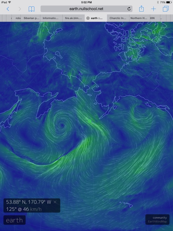
(Long
wave north to south synoptic pattern projected to draw warm air and
water into the Pacific side of the Arctic over the next 3-6 days.
Image source: Earth
Nullschool.)
In
the above image from Earth Nullschool and based on GFS models, we can
see the strong south to north synoptic wind pattern predicted to set
up. Flowing from a region near Hawaii, these winds are predicted to
pull tropical airs over thousands of miles, run them up through the
Bering and into the High Arctic.
In
conjunction with this warm air invasion, a head of hot water now at a
+5 C positive anomaly in the Chukchi will be driven northward running
directly into highly fractured and disassociated ice floes. It’s a
weather pattern that is a continuation of consistent warmth hitting
the sea ice on the Pacific side of the Arctic. One that is driven
both by El Nino and by a human greenhouse gas based amplification of
heat in the polar zones. This combination has generated a kind of
Achilles heel for Arctic sea ice on the Pacific side for 2015. With
another hit coming to this area and with sea ice already in a
somewhat tenuous state due to the continued impacts of warm air near
Greenland, a Greenland high and a related dipole continuing to nudge
the ice toward the Fram Strait, risks rise that current sea ice
measures ranging at 4th lowest in area and 7-9th lowest in extent
could take a further tumble.
Links:
Hat
tip to Greg


No comments:
Post a Comment
Note: only a member of this blog may post a comment.