

This is what I thought when I looked at sea temperatures around the Pole on Climate Reanalyzer.
"Temperatures for most of the Arctic basin in ice-covered areas are expected to again push to -2 C to +2 C. Generally, air temperatures below -2 C are needed to prevent melt, but in warm water and rough ocean conditions, which have tended to dominate the Arctic recently, air temperatures probably need to average around -4 to -6 C over most of the Arctic to fully halt melt."
Robertscribbler, despite describing the situationvery well repeats that this is a comparitively weak melting year - and objectively air temperatures have been lower because of higher cloud cover. But the destruction of the ice is coming from a different situation and the future situation depends on sea temperatures and weather conditions over the sea ice melt.
A blue sea event this may not be but the ice that has been destroyed over this summer season is never coming back.
This is what I thought when I looked at sea temperatures around the Pole on Climate Reanalyzer.
Robertscribbler, despite describing the situationvery well repeats that this is a comparitively weak melting year - and objectively air temperatures have been lower because of higher cloud cover. But the destruction of the ice is coming from a different situation and the future situation depends on sea temperatures and weather conditions over the sea ice melt.
A blue sea event this may not be but the ice that has been destroyed over this summer season is never coming back.
Coming Big Arctic Ocean Warm-Up May Extend Sea Ice Melt Season
10
September, 2016
It’s
September in the Arctic, a time of year when temperatures should be
cooling off. But with sea ice at second-lowest levels on record in
most monitors and the globe experiencing an unprecedented hot year,
it appears that the next week may see the Arctic Ocean reverse its
typical seasonal cooling trend and significantly warm up over the
coming five to six days.
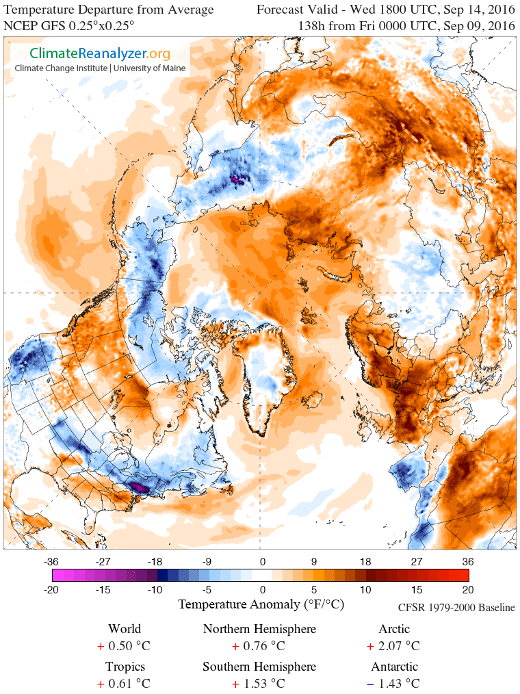
(GFS
model runs show a significant warming is in store for the Arctic
Ocean over the coming week — and that’s bad news for sea ice
running at second-lowest levels on record in the current daily
measures and lowest levels on record for the first eight months of
the year so far. Image source: Climate
Reanalyzer.)
GFS
model runs show a strong pulse of warm air will rise up over the
Atlantic Ocean and Barents Sea in the next 72 hours. This warm
air then will ride in over the Greenland Sea and invade the
Arctic Ocean north of Svalbard. Local temperatures over water are
expected to be between 4 and 8 degrees Celsius above average over a
broad region of the Arctic. Meanwhile, general departures for the
entire region above 66° North Latitude are expected to hit around 2
to 2.5 C above average.
Temperatures
for most of the Arctic basin in ice-covered areas are expected to
again push to -2 C to +2 C. Generally, air temperatures below -2 C
are needed to prevent melt, but in warm water and rough ocean
conditions, which have tended to dominate the Arctic recently, air
temperatures probably need to average around -4 to -6 C over most of
the Arctic to fully halt melt.
Threats
to Ice Coming From All Directions
During
summer and early fall, the Arctic Ocean tends to help to moderate
temperatures over the region, so these are very high predicted
temperature departures for this time of year. Such high temperatures
are likely due to the effect of added heat bleeding off recently
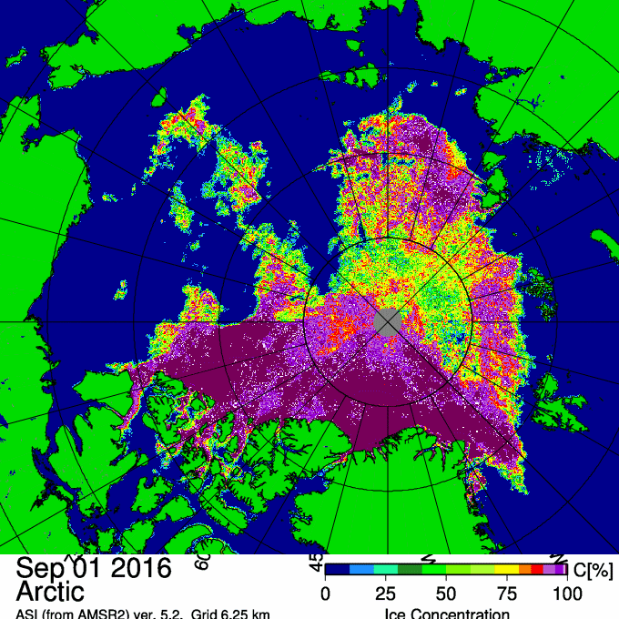
ice-free waters. While sea-ice area and extent measures are in the
range of second-lowest on record, there is some indication that
sea-ice concentration in the Arctic may be at or near record-low
levels.
(AMSR2 animation constructed by Neven shows vigorous ice export and melt through the Canadian Arctic Archipelago. This is a heavy blow to the thin veil of multi-year sea ice remaining in the Arctic. Animation by Neven at the Arctic Sea Ice Forum. Images byUniversität Bremen.)
The
ice, generally, is extraordinarily weak, thin and dispersed. Large
gaps run across an arc covering the Atlantic and Siberian side of the
polar zone. In addition, large cracks are appearing in the very thin
and unstable multi-year ice north of Greenland (below) as sea-ice
export now threatens melt in the Beaufort Sea, Canadian Arctic
Archipelago, the Nares Strait, the Fram Strait, and on into the
northern edge of the Barents Sea.
Risks
Rise for a Long Melt Season
Recent
animations by
Neven over at the Arctic Sea Ice Forum (above)
show particularly strong export and melt in the Canadian Arctic
Archipelago — which is a pretty unprecedented melt feature. What
this means is that the ice is basically being hit from all sides and
that the factors necessary to melt ice are compounding.
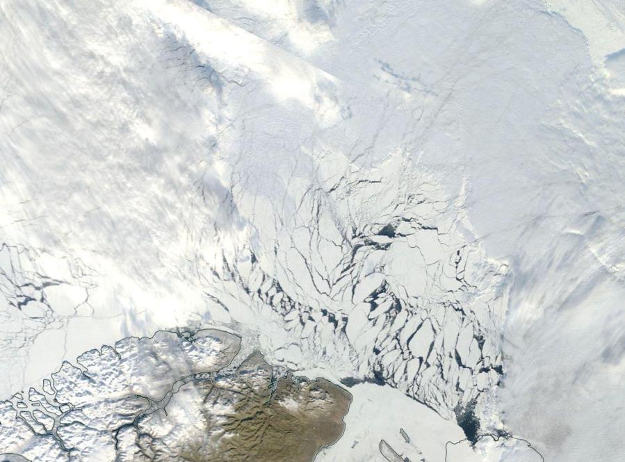
(Large
section of multi-year ice breaking up north of Greenland on September
9, 2016. In recent years, less and less ice has survived summer
melt to make it to the following winter. Ice with an age of more than
five years has grown quite scant in the Arctic. The ice
shown breaking up in the above image is part of the last
bastion of old, thick ice in the Arctic. When that’s gone, the
Arctic Ocean will only be a seasonally frozen sea, a possibility that
may occur as soon as 2017 to 2025 and will probably occur before
2035. Image source:LANCE
MODIS.)
If
the big warm-up does occur as predicted this week, there is risk that
ice losses will extend through to September 15 and possibly beyond.
These melt rates should not be particularly severe, given the time of
year, but it is possible that 50,000 to 300,000 square kilometers or
more will go. This would be enough to solidify 2016 as the
second-lowest year on record for extent and area at the end of melt
season. It would also help to fill the big gap between 2007 and 2012
— solidifying already significant decadal melt trends.
Overall,
this is a pretty weird forecast, but set in the backdrop of a year
that’s on track to be about 1.2 C above 1880s averages — the
hottest year on record by far — the possibility of a late-season
Arctic warm-up and a late end to a near record melt season is an
entirely valid one.
Links:
Hat
tip to Greg
Hat
tip to DT Lange
No comments:
Post a Comment
Note: only a member of this blog may post a comment.