

A Bit More Like a Perfect Storm — Hurricane Force Wind Gusts, Record Low Pressure, Potential Record Rainfall on Tap for Northern New England
28 October, 2017
An area of disturbed weather in the Caribbean has now organized into tropical storm Philippe and is likely to continue to intensify as it moves north and east over Cuba to skirt Southern Florida this afternoon. The storm is then expected to race northward off the Eastern Seaboard — rapidly intensifying as it transitions to extra-tropical by Monday.
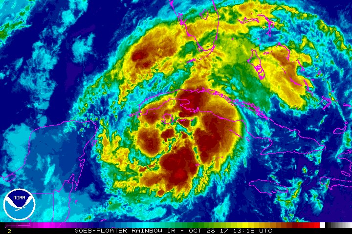
Tropical Storm Philippe has formed near Cuba. Interaction with coastal low near New England Sun/Mon could mean an even stronger nor’easter.
This rapid intensification will be fueled by a combination of warmer than normal sea surface temperatures off the U.S. East Coast and by the tropical system’s collision with a colder and very deep trough sweeping down from the north. The interaction of trough, storm, and warmer than normal surface water is predicted to generate some record-breaking extreme weather for the U.S. Northeast by Sunday through Monday.
Record-Breaking Nor’Easter on Tap
Present weather model forecasts now call for a stronger storm than was predicted yesterday. The primary low pressure cell associated with the storm is now expected to hit pressures in the range of 975 to 965 mb as it cartwheels off New Jersey and New York and makes landfall somewhere between Rhode Island and Coastal Maine. Such pressures would substantially break past records for lowest pressure in a Northern New England storm during late October. Sandy featured lower pressures as it roared into New York. But the present storm track brings a record intensity storm further north than Sandy.
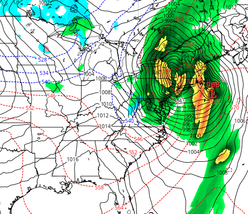
(A 968 mb storm making landfall in Northern New England on Monday would be a record event for October. Image source: Tropical Tidbits.)
As this hybrid storm rockets in from the much warmer than normal ocean, it is expected to bring with it hurricane force wind gusts and extreme one day rainfall amounts for the region. Weather models now show that sustained winds may exceed 60 mph for the New York, Connecticut, Rhode Island, Massachusetts, Vermont and Maine coasts. Meanwhile some models are indicating hurricane force gusts of up to 92 mph or higher for the region. Rainfall totals over a rather short time period are also expected to exceed 4 inches over a broad area stretching deep into New York state. It’s worth noting that the system will inject unseasonably warm air into Northern New England. So most of the precipitation associated with the storm is presently expected to fall as rain.
The storm’s associated powerful winds will likely drive a stronger than usual storm surge for a Nor’Easter into coastal areas — with flooding more reminiscent of that of a moderate hurricane. We could also see electricity knocked out for more than a million residents as this potentially record-breaking system moves in.

Headed to New England for the massive nor’easter that will bring very high wind and heavy rain Sunday/Mon. Gusts to hurricane force possible
(Model predictions show the possiblity for wind gusts of up to 92 mph in extreme developing Nor’Easter expected to impact New England on Sunday and Monday. Winds more typical of a hurricane than your usual coastal storm. It’s worth noting that the Euro Model has come up with some quite extraordinary wind gust conditions ranging from 111 mph to 129 mph in the highest range models. Consensus models appear to be indicating a somewhat milder, but still very strong, storm.)
Climate Change Related Influences Results in Unusual Storm
We should also note that the moisture feed bleeding into this particular storm is quite intense. And as with other recent events we could see projected rainfall totals exceeded. This due to a heavier atmospheric moisture load and related intense convection associated with atmospheric temperatures that are now, on average, 1 to 1.2 C warmer than late 19th Century temperatures. And such warmer temperatures, set off primarily by human fossil fuel burning, are now increasing the peak intensity of extreme rainfall events.
As noted in yesterday’s post, the factors involved in the present Nor’Easter are rather odd when considering past contexts. For one, winds will tend to blow from the south. This is indicative of a somewhat off-kilter track when compared to a typical Nor’Easter. In addition, various climate change associated elements like the high amplitude trough related to polar warming, the joining of tropical weather with Arctic-originating weather to generate an overall more intense storm, an enhanced overall convection and related increased winds and rainfall rates, and the fuel provided by warmer than normal sea surface temperatures are all factors related to human-caused climate change.
Links:
No comments:
Post a Comment
Note: only a member of this blog may post a comment.