

200+ Million in Danger - Freak Storms & Flooding ahead for USA & Canada & Europe
Warmed, Wet and Blocked: Another Storm Taking Aim at the Flooded Central U.S. is Expected to Transition into a Stalled Nor’Easter
27
February, 2018
The
Ohio River Valley is
now reeling from the worst flooding event of the past 20 years.
Yet one more major event fueled by disruptions to the Earth’s
atmosphere facilitated by human-caused climate change. But with
another serious plume of moisture issuing from the warmer than normal
waters of the Gulf of Mexico, more heavy rains are heading toward a
storm-battered Central U.S.
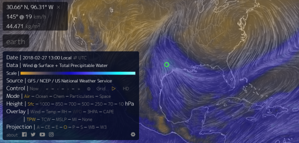
(One
more big moisture plume arises from a warmer than normal Gulf of
Mexico. It will help to fuel a major storm system that is expected to
impact a large swath of the U.S. for most of this week. Image
source: Earth
Nullschool.)
The
set-up is similar to previous events of the past two weeks. A strong
high pressure system over the Northeast is pulling a heavy load of
moisture from a much warmer than normal Gulf of Mexico. Sea surface
temperatures there, according to Earth
Nullschool reanalysis,range
from less than 1 C warmer than normal in the southern Gulf to as much
as 5 C warmer than normal in the northern Gulf. Last week, these
warmer than normal sea surfaces helped to fuel record
atmospheric moisture levels along with historically heavy rains.
This
week’s atmospheric moisture pulse will be picked up by a trough
sweeping into the Central U.S. over the next couple of days. There,
it will help to pump up a series of heavy storms that are
predicted to dump another 3-7 inches of rain over the Mississippi
River Valley this week.
Note that this is on top of the 5-15 inches of rain that has already
been dumped over the region during the last two weeks.

(NOAA
composite radar imagery shows
observed precipitation totals for the U.S. during the past 14 days.
Note that another batch of heavy rains is headed directly for the
region that has already been hit the hardest.)
Persistent
extreme weather patterns of this kind are an aspect of human-forced
climate change in that polar warming can result in Jet Stream
blocking patterns that cause weather systems to stick around or
repeat for long periods of time. This is particularly the case with
the storm system now developing in the Central U.S. For as the storm
strengthens and moves slowly eastward, it is expected to deepen into
a powerful coastal low. This
low is predicted to then rake the Northeast U.S. coast with 60 mph
winds, heavy rain, high surf and coastal flooding.
As
the storm’s eastward passage is blocked by the
same weather system that so
recently warmed the far north to such extreme winter temperatures,
it is expected to linger off the U.S. East Coast even as it
intensifies. Due to this predicted stall, the Northeast U.S. is
facing the potential of multiple storm tides in which wind-driven
water piles up — exacerbating coastal flooding.
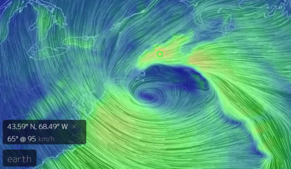
(Very
strong northeasterly winds are expected to rake the coasts of Maine
and Massachusetts by March 2 according to GFS model forecasts. Image
source: Earth
Nullschool.)
Though
the shape of the present storm is still a bit unclear, it is likely
to both further exacerbate already severe flooding over the Central
U.S. even as it generates some serious coastal flooding potentials
for the Northeast by the end of this week. What is also clear is that
a warming polar environment is contributing to these upstream severe
weather events by increasing their persistence even as warming ocean
surfaces are helping to feed them with larger moisture loads which
generates higher potential storm and rainfall intensity.
No comments:
Post a Comment
Note: only a member of this blog may post a comment.