

I feel so disheartened and sick at heart I am unable to post anything.
Not only do we have to deal with the reality of rapid changes on the planet that no one seems to care a share about and everyone lies about but we have an evil,dystopian world of lies, crisis actors and.... I can't find the words.
Quite frankly I feel suicidal.
A
Large Area of Open Water Forms in the Melting Sea Ice North of
Greenland During February
26
January, 2018
In
concert with an
unprecedented polar warming event,
it now appears that the Atlantic side of the Arctic Ocean is seeing
some severe sea ice loses.
Warm
winds blowing at up to gale force intensity from the south have
assaulted the ice with high waves and above-freezing temperatures for
about four days now. The ice edge north of Svalbard is being rapidly
beaten back. Perhaps more disturbing, is the fact that the ice pack
to the north of Greenland has also now withdrawn — opening up a
huge polynya.
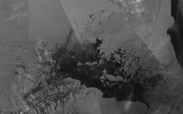
Looking at the N.
Greenland area, we find a fractured, thinning mess along a region of
sea ice that should be meters thick and growing thicker at this time
in February. Such a state would be remarkable during summer time, but
is much more-so in what should be the dark chill of winter polar
night.
To
be clear, as
Neven notes in his most recent Sea Ice Blog,
it’s not simply wind blowing the ice around here. It’s melt due
to temperatures rising between 40 and 60 F above average over a large
region of the Arctic. A
region that yesterday saw a 33-34 F above freezing temperature at the
North Pole.
An updated time series for Cape Morris Jesup, Northern Greenland using DMI's hourly values.
The last 10 days have seen a series of swings near and above freezing. pic.twitter.com/v87fzaWLNP
In 2018, there have already been 61 hours above freezing at Cape Morris Jesup, Greenland.
The previous record was 16 hours before the end of April in 2011. pic.twitter.com/BCgcxAtKng

The
underside of sea ice melts at around -2 F, due to the salt content in
the water. But surface portions of the ice still need above freezing
temps to result in melt and ponding. Since this region of the Arctic
tends to remain near or well below freezing year-round, the present
temperatures are enabling unprecedented
winter damage to the ice and
the environments it supports.
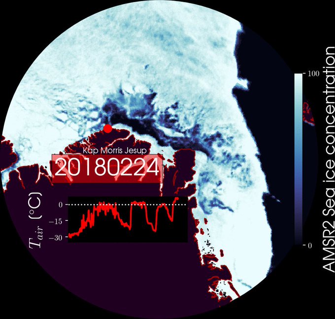
There is open water north of #Greenland where the thickest sea ice of the #Arctic used to be. It is not refreezing quickly because air temperatures are above zero confirmed by @dmidk's weather station #KapMorrisJesup. Wacky weather continues with scary strength and persistence.
These
record daily and seasonal lows are occurring following a
major loss of ice in the Bering Sea and
in concert with the rapid sea ice setbacks we are presently seeing on
the Atlantic side.
It is possible, given the
present trend, that the Arctic will experience back-to-back years of
record low seasonal ice during winter. 2016-2017 saw a crash in
winter sea ice and we are presently even below the record low extents
seen at that time
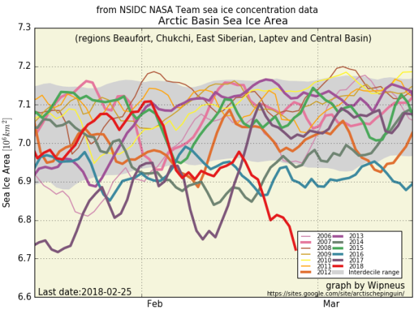
(Arctic
Basin sea ice is at record lows and trending lower. Image source: The
Arctic Sea Ice Blog.
Graph by Wipneus.)
Only
a month and a half of typical freeze season remains. But ten day
forecasts indicated that Arctic mean temperatures might return closer
to normal ranges (0 to 1 C above average as opposed the 3-6 C above
average) and
could allow for some recovery to the substantially reduced winter ice
pack.
Overall, though, the tale
so far has been one of highly unusual melt and warming. One that
highlights the serious and worsening impacts of human-caused warming
and related polar amplification.
(UPDATES TO FOLLOW)
No comments:
Post a Comment
Note: only a member of this blog may post a comment.