

Climate
Change Driven Record Atmospheric Moisture Produces Major Flooding in
Central U.S.
23
February, 2018
Ten
inches. That’s
how much rain has fallen over parts of the Central U.S. over the past
week.
Five-to-ten inches more. That’s how much additional rain could
again fall across the same region during the next seven days
according to NOAA’s forecast (see below image).

****
Warnings
of potentially life-threatening flooding were
issued today from Michigan to the Ohio Valley and on through a large
swath stretching from Texas into Arkansas as severe rainfall again
inundated the Central U.S.
A
massive double-barrel high pressure system sitting off the U.S. East
Coast generated strong south-to-north winds running over sea surfaces
in the Gulf of Mexico ranging from 1 to 5 C warmer than average.
These winds reaped the waters of a much larger than normal load of
water vapor and then pumped it over the Central U.S. The
result was record atmospheric moisture levels running
over the region producing significant and abnormally intense rain
storms. Now, many areas are under flood warnings with
moderate-to-major flooding expected.
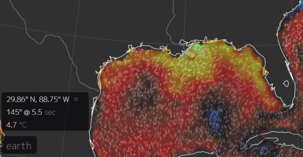
1-5
C warmer than normal ocean surfaces, as we see in the Gulf of Mexico
today, is an extraordinary anomaly. In the past, 2 C warmer than
normal readings would have been considered significant. But with
human-caused climate change, sea surface temperature anomalies have
tended to become more and more extreme.
Though
warmer than normal Gulf of Mexico waters are contributing to the
presently severe precipitation now falling over the Central U.S.,
they are not the only waters seeing such high temperatures. In fact,
the global ocean is now much warmer than it was in the past and, from
region-to-region, produces abnormally high surface temperatures with
increasing regularity. These warmer waters have pumped more moisture
into the Earth’s atmosphere which has led to an increase in the
number of extreme rainfall events both in
the U.S. and across
the globe.
A signal of human forced climate change.
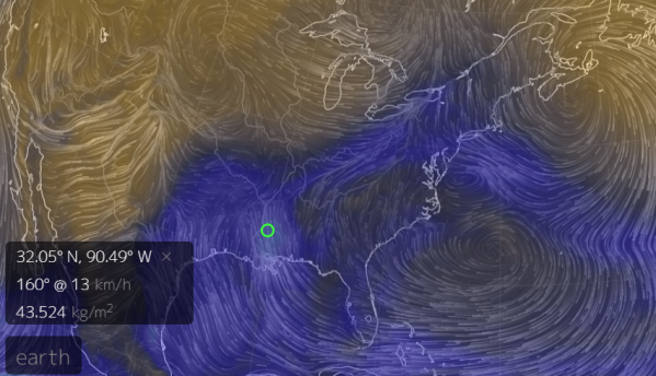
The
large high pressure system driving such a significant moisture flow
over the Central U.S. today is also climate change related. Earlier
this week, the high hit a record intensity — spurring a
never-before-seen spate of record warm temperatures across the U.S.
northeast. The high, in its turn was
fueled by a warming-driven polar vortex collapse in the Arcticwhich
generated the intense ridge pattern that allowed it to bloom and
sprawl.
What
we are seeing, therefore, is a kind of climate change related synergy
between severe polar warming and more intense ridge and trough
patterns in the middle latitudes. Add in the factor of warmer sea
surfaces and this
changed atmospheric circulation is
enabled to more efficiently tap related higher atmospheric moisture
levels to fuel the more intense storms we’re seeing today.
No comments:
Post a Comment
Note: only a member of this blog may post a comment.