Hot Blob off Southeast Australia Fuels Life-Threatening Rain Bomb Event
30
November, 2017
Hot
Blobs.
These pools of severe warmth at the ocean surface have, during recent
years, fueled all kinds of climate change related extreme weather
ranging from droughts to floods to
record hurricanes.
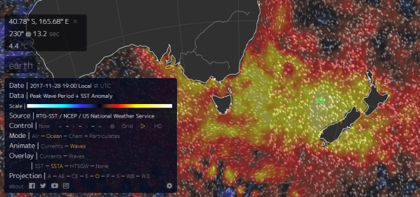
(Hot
blob southeast of Australia features ocean temperatures as high as 8
F [4.5 C] above average. This is an extreme climate and severe
weather-triggering feature related to climate change. One that has
also been associated with strong, persistent atmospheric ridges and
related high pressure systems. Image source: Earth
Nullschool.)
The
blobs themselves often
form under persistent and strong high pressure systems which lock-in
both heat and high rates of evaporation.
These highs, sometimes called resilient
ridges,
are thought by a number of experts to be an upshot of changes to both
atmospheric circulation and energy balance as a result of the Earth
warming. They are an example of the kinds of extreme climate and
related severe weather triggering outliers you would tend to expect
in a warming world. A new kind of weather phenomena producing new
effects.
Today,
sea surface temperatures between Australia and New Zealand are
ranging as high as 8 F (4.5 C) above average. A very significant warm
temperature departure for this area of ocean. One that well meets the
qualification for the term ‘hot blob.’ The large blocking high
associated with the blob has, for some time now, been
circulating very
high volumes of moisture evaporating
off these much warmer than normal waters over Eastern Australia. This
moisture loading provides fuel for powerful storms in the form of
both more explosive atmospheric lift and higher rainfall potential.
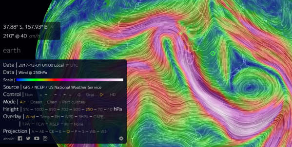
(Ridge-tough
dipole triggers extreme weather in region prepped by moisture venting
off an ocean hot blob. Image source: Earth
Nullschool.)
All
that heat and moisture bleeding off the hot blob just needed a
catalyst to produce the kind of climate change related event I’ve
been calling a ‘rain bomb.’ And, unfortunately for Southeast
Australia, just this kind of catalyst in the form of a sharp facing
trough in the Jet Stream and related upper level low forming over
South Australia is on the way.
From
today through late Friday, this low will generate added atmospheric
energy that will produce very severe thunderstorms over Southeast
Australia. Ones capable of generating extreme rainfall amounts in
excess of 2 inches per hour over certain locations. With
total rainfall amounts hitting between 4 inches (100 mm) and 12
inches (300 mm) between
now and late Friday.
(Predicted
extreme rainfall event is being fueled by very warm sea surface
temperatures to the east.)
The
storm system will also generate strong winds, lightning, and tidal
flooding for some locales.
This
is a dangerous event risking loss of property and life with a number
of climate change related factors involved. Those in the areas
affected should stay tuned to local weather (BOM) and government
emergency management for storm and response information.
CREDITS:
Hat
tip to Colorado Bob
Hat
tip to Vic
Alert: sea surface temperatures (SST) are way hotter than normal.
Via
Facebook
Here
is November Sea Surface temperatures for recent years, prepared by
Sarah Ugalde at IMAS, care of data from IMOS.
Context:
2015/2016 was a severe marine heatwave, off the charts, there were
large scale impacts observed to natural ecological systems and to the
aquaculture industries, both of which were (and are still) not
equipped to adapted to the conditions they saw.
Personal
opinion/guess: 2017/2018 is shaping up to be much, much hotter than
2015/2016. We could be about to witness an ecological disaster, and
aquaculture might take a hit too. Let’s hope it’s possible for a
cold marine system to offer some relief.
This
is what we would expect, and have projected, climate change to look
like - Spikes of unusual weather that systems can’t deal with,
followed by ecological (or food production) collapse.
NZ Rainfall shortage 'dramatic'
Farmers
are keeping a close eye on the rain radar, as soil moisture levels
plummet.
30
November, 2017
Niwa's
summer outlook is forecasting
warmer than average temperatures for
the whole country and an increase in rainfall for the top of the
North Island.
Canterbury
based farm consultant John Ryan said the soil moisture levels have
gone from too wet to too dry in the space of a month.
"There's
been a dramatic shortage of rainfall to put it bluntly. We're now
facing soil moisture deficits on most properties."
Niwa
meteorologist Ben Noll said farmers were dealing with much drier
ground than last year.
The
North Island and much of the South Island measured well below normal
soil moisture levels, he said.
"It's
most pronounced in the west, so we're talking about places from
western Northland ... down into the Wairarapa and Wellington regions,
and then covering much of the South Island interior parts and
particularly along the West Coast of the South Island."
Wilting
point, which is the minimum amount of soil moisture needed to sustain
plant growth, is also low.
"Some
places are already at, or approaching, the wilting point - so this is
quite significant from an agricultural perspective.
"Places
like Greymouth, Mount Cook, Arthur's Pass ... places in Canterbury
like Lincoln, which is tracking for its second driest month overall
since records began in 1881."
Mr
Noll said the dry weather was set to continue because of La Nina
conditions.
"In
the short term it does not look like much help will be coming for
those dry soils."
Mr
Ryan, who farms in Tai Tapu near Lincoln, said the lack of rain in
the region was affecting growth on farms in the region.
"We've
really missed out on perhaps 50 percent of the normal bulk of the
spring growth because on the lighter land as soon as they come under
pressure ... most grass species go immediately to sed."
Weather
patterns were making some farmers plan further ahead, he said.
"I've
had people de-stocking ewes and lambs all counted since early
November, simply to create space and to not put themselves under
market pressure later in the season."
People
were not panicking yet, but should do their homework, Mr Ryan said.
"Nothing
like getting two or three auctions in line for the cut-off date for
various auctions, to be proactive and make a move before the
situation becomes difficult."
Mr
Ryan said the good news is that prices for all markets, except
cross-bred wool, were well above recent years.
****
On Facebook someone who is more aware than most expressed the following:
"Rainfall for Victoria lll result in major flooding for SE Australia and drought relief for western NSW and Central Victoria"
Unofortunately, with those high water temperatures in the Tasman I'm not so sure. We can easily get a one-off dump and rain and not make a dent in drought condiitons.
In the meantime, I have seen little mention of the la-Nina which should theoretically bring wetter and cooler conditions.
Meantime, where I am (in Wellington, New Zealand) it as hot and certainly drier on the first day of summer than it was at the height of summer during the height of the el-Nino a couple of years ago.
This is borne out by the comparative figures for sea temperature anomalies for the Tasman Sea, between Australia and New Zealand.
This is borne out by the comparative figures for sea temperature anomalies for the Tasman Sea, between Australia and New Zealand.


No comments:
Post a Comment
Note: only a member of this blog may post a comment.