Showing posts with label Tasman Sea. Show all posts

Sunday, 1 November 2020

Another marine heatwave in the Tasman Sea

 NZ's seas are running hot: Is a marine heatwave coming?


NZ Herald,

1 November, 2020


New Zealand's coastal waters are running hotter now than they were at this point three years ago - when the country was enveloped by a freak marine heatwave that fuelled our warmest summer.

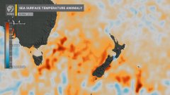
Meteorologists have been keeping a close watch on warming sea surface temperatures (SSTs) - some pockets have been reaching 3C above average - as an arriving La Nina climate system begins to influence our weather.

Already 15 spots around New Zealand are on track to register record or near-record dryness for October.

Niwa forecaster Ben Noll said local SSTs had warmed "quite notably" since September, with waters north of the North Island sitting at just over 1C above average.

"So that's pretty impressive. The most anomalous waters are sitting off the west coast of Auckland where, over the past seven days, SSTs have been as warm as 2C above average," he said.

"And looking further west, as you go more into the Tasman Sea, there are actually pockets of water that have been as much as 3C above average."

Source / Niwa
Source / Niwa

It pushed SSTs to 1.5C above average - and as high as 6C above normal in some spots off the West Coast - as beaches became crowded weeks earlier than usual, and mussel beds and seaweeds around Southland and Otago suffered cascading losses.

Interestingly, Noll said, our waters were running warmer now then at this point in 2017.

Along with a La Nina, another similarity with three years ago was a positive phase of a key indicator called the Southern Annular Mode (SAM).

A positive SAM had meant weaker westerly winds than normal over the South Island with higher pressures - and fewer cold fronts crossing New Zealand with bursts of cold air.

It also blocked highs to the east of the country, while less churn of local ocean waters allowed the sea surface to warm.

"For people who work within the fisheries and marine sectors, I'd say keep a very close eye on the situation - they might even be able draw on their experiences from late 2017 and early 2018 to get a guide of this potential."

Another marine heatwave would mark the third in just four years - and these events are expected to become longer, stronger and more frequent under climate change.

Warmer seas also correlated to warmer air on land - driving hot spells and the further melt of our alpine glaciers.

"It means that, when it comes to things like high temperature extremes, the dice are probably loaded as we work our way through the end of spring and into summer."

As it stood, Niwa was forecasting above average temperatures around the country for the next three months - and a slightly more active tropical cyclone season.

Noll added October had been unusually dry for many places.

Rainfall data from the past week showed Waiouru, Whakatane and Auckland - at Motat - were on track to record their lowest levels of rainfall on the books.

Other locations including Hawera, Levin, Hicks Bay, Martinborough, Masterton, Te Puke and other parts of Auckland have similarly seen one of their driest Octobers on record.


https://www.nzherald.co.nz/nz/la-nina-and-climate-change-why-auckland-is-set-for-a-hellishy-humid-summer/IBIG3EPCV4RHXS7UE7AH4RVCTY/


Wednesday, 15 July 2020

Winter in New Zealand - the hot blob in the Tasman has dissipated

This is what I was reporting last year, along with super-warm conditions.

Image may contain: sky, cloud and outdoor

Image may contain: sky, cloud and outdoor

We are having something more akin to a winter - with colder conditions but very little sun.

The meteorologists and people on social media will interpret this as "part of a cycle" and see it in terms of localism.  However the Bot Blob has more or less dissipated compared with elsewhere on the Globe.

Look at the Arctic!


Monday, 8 April 2019

When is a headlines a LIE?


Once again I am moved to write about the way that the mass media misleads (I would go further, and says LIES) about something as basic as the winter.

Every time a weather low comes through “autumn" (or even "winter") is on its way


We are into April and following a few genuinely cool days which also brought a huge downpour to the capital the temperatures up right up there again up to 24 degrees Celsius.

Just over a week ago on a visit to the farm to visit the horses I measured temepratures of just short of 30 degrees Celsius in the grass and in the shade.

I described this in this selfie:


These temperatures are FAR HIGHER than the average for this time of year and even exceed the AVERAGE MAXIMUM for this time of year by many degrees.

If the following chart is accurate, the 'winter' weather that we were thrust into didn't even make it down to AVERAGE MINIMUM for February!!.


Well, I can tell you why the temperatures are so high in a very simple way that the pundits never will - an ongoing marine heatwave that this map shows is affecting New Zealand even more than Australia.


So why does the mainstream media misinform its readers so much about not only the climate  but also the WEATHER?

There has been more than ever in the media about climate change, informing people that they may have to move away from the coast some time in the next hundred years (sic).  Then they spare no effort to pull the wool over the eyes of the public with headlines like the ones below.

Every time there is an extreme weather event which lasts a few days before the temperatures rise again the headlines tell us that we are moving into 'autumn' - and sometimes even that we are moving into 'winter'.

They are never going to tell you about the trees that lose their leaves far too late or come into flower in the depths of winter. As I have pointed out previously the last year where I recall a classic winter in the capital with regular frosts was wasy back in 2003.

Quite frankly, with official and media coverage I do not blame ordinary folks for being very confused, even sceptical - the information is so contradictory, so misleading.
Just take the following headlines:


One particularly egregious example of what I would call BULLSHIT is this headline from just under a year ago- they were predicting the coldest winter in years
And what was the reality of the "coldest winter in years"?
As you can see from this report from NIWA the winter in 2018 was New Zealand’s 6th-warmest on record

A mild winter for much of the country and dry in parts of the South Island


Winter 2018 was New Zealand’s 6th-warmest on record. Temperatures were above average (+0.51°C to +1.20°C of the winter average) or near average (-0.50°C to +0.50°C of the winter average) for most of the country. Winter temperatures were well above average (> +1.20°C of the winter average) for much of north Canterbury, and a few other isolated inland locations.
***
I am moved to write about this at regular intervals.
Here are a couple of previous items.


How the weather service lies about daily temperatures


As I have pointed out I have been keeping a record of daily temperatures at home in Alicetown, Lower Hutt.


What I have noticed and have been recording is how daily temperatures have been warmer than that reported by Metservice. In particular the minimum temperatures have been much warmer than what one would “expect” and what has been reported on the internet.

For example the other day the minimum night-time termperature was a toasty 12 degrees Celsius whereas Metservice reported the minimum temperature as being 8 degrees Celsius.

The maximum temperature for the day was reported as 12 degrees. It was over this at breakast time and reached almost 20 degrees!

I decided to ring Metservice to get their explanation for this state of affairs.

After a long-winded explanation from a helpful meteorologist it turned out that the situation is that the temperatures I read every day are a forecast the comes from a model which uses average temperatures as part of the equation.

In other words, nothing that has any bearing with reality!!

The discussion is recorded below:


If I want the actual recorded temperatures I have to scroll down further.


"You’ll see the forecast high and low for today at the top of the tab (14C and 8C respectively).


"The observed temperatures you can see to the left of the line in the graph portion of the image (you can see the lowest temperature recorded this morning was 12C between 4am-6am).


"If you would like to check out weather observations further back from today you will have to scroll down the webpage (past the headings for Social Media Gallery and Maps, Radars and Videos) to the ‘Past Weather’ heading. This is a great resource for checking observations. The default view will show maximum/minimum temperatures, total rainfall and maximum wind gust and wind speed for each day in the past 30 days. You can change this to show you more detailed info for the yesterday only, or less detailed info for the 2 years along with the historical averages"

Warmer-than-usual weather in NZ as we head towards an el-Nino

In my 62 years on the planet – or most of it – May has always meant the beginning of the cold weather and the first frosts.

It is in the nighttime temperatures I notice the biggest difference. I have been waking up in the middle of the night sweating under my duvet. Never mind the colder South Island but the statistics tell me the mean lowest temperatures for Lower Hutt where I love should be 6.9C.

When I woke last night it was 12C


The statistics that the average temperature should  be 12.1C and the mean highest temperare is 15.0C.

Today, according to the internet the temperature late-morning is 15C whereas my thermometer in the garden tells me it is 17C.

That is a pretty significant deviation from the norm.

You'l have to take my word for it but we are 3 weeks into May and the temperatures have hardly been any different throughout that time.

We have not yet had anything that is close to a frost in that 3 weeks.


Meanwhile the media (mostly overseas as far as I can ascertain from DuckDuckGo) has reproted the largest wave ever recorded - 78 feet (23.8 meters).


Tuesday, 26 March 2019

The role of a marine heatwave in the Tasman Sea in creating the atmospheric river


Marine heatwave a factor in the West Coast's torrential rain


Stuff.co.nz,
25 March, 2019

We've had the benefits of the marine heatwave - the hot summer days and warm seas. Now comes the downside - torrential rain.
Those western parts of the South Island tucked close in to the Southern Alps are in for the kind of deluge which the National Institute of Water and Atmospheric Research (Niwa) says occurs less than once a year on average.
Even on our traditionally wet West Coast you can't get more than half a metre of rain in the space of 36 hours without some extra help.
Torrential rain has begun moving slowly up the West Coast, with more than half a metre expected in places close to the main divide. File pic: Heavy rain at Franz Josef settlement.
GEORGE HEARD/STUFF
Torrential rain has begun moving slowly up the West Coast, with more than half a metre expected in places close to the main divide. File pic: Heavy rain at Franz Josef settlement.
In this case, that's coming from the superheated Tasman Sea and a pipeline of tropical moisture extending from Australia and tropical cyclone Veronica, and former tropical cyclone Trevor.
READ MORE:
Heavy rain in South Island a 'significant weather event', Metservice says
What does marine heatwave mean for future of New Zealand's fish?
Warm seas fuelling major changes in weather patterns around NZ
Tropical Cyclone Veronica is still affecting the northwest coast of Western Australia, while ex-Tropical Cyclone Trevor lies over the Northern Territory and western Queensland.​
The marine heatwave in the Tasman Sea and east of the country has lifted sea temperatures by several degrees and brought some very warm days during the 2018-19 summer.
STACY SQUIRES/STUFF
The marine heatwave in the Tasman Sea and east of the country has lifted sea temperatures by several degrees and brought some very warm days during the 2018-19 summer.
Niwa Weather meteorologist Ben Noll told Stuff, sea-surface temperatures in the Tasman Sea were still a lot warmer than average. A patch of sea northeast of Tasmania had a temperature of about 25 degrees Celsius.
"We haven't really retreated from the summer. That is amazing. And stretching right across a broad range of the eastern Tasman the seas are 3 or 4C above normal. It is still toasty.
"We often look at ocean temperatures in terms of one or three-month blocks. It is this persistence that will influence these types of weather systems.
A previous heavy rain event, causing the Waiho River at Franz Josef to swell.
GEORGE HEARD/STUFF
A previous heavy rain event, causing the Waiho River at Franz Josef to swell.
"So when you have a weather system like this over those warmer heatwave seas, there's more water vapour available to the atmosphere for cloud and rain."
There was also a pretty clear "atmospheric river" - a tongue of moist, sub-tropical or tropical air - streaming from Australia across the Tasman Sea on to the West Coast, Noll said.
Some of this "extra moist" air had been wrapped up in the two tropical cyclones and was being siphoned across thousands of kilometres. When this air was forced to rise on meeting the Alps it produced torrential rain.
In February 2018, torrential rain and high winds brought down trees, which blocked State Highway 6 north of Franz Josef.
GEORGE HEARD/STUFF
In February 2018, torrential rain and high winds brought down trees, which blocked State Highway 6 north of Franz Josef.
"The impacts of over 500mm of rain are potentially landslips, road and bridge washouts. On the positive side, the hydro lakes are in need of a fill and there's going to be spillover rain into those, with potentially 200-400mm of rain in the Waitaki catchment.
There would be a sharp drop-off in the amount of rain on Tuesday across the Canterbury Plains, with possibly 20mm or so later in the day reaching the coast near Christchurch, he said.
The heaviest falls south of about Hokitika would be on Tuesday morning, spreading further north in the afternoon.
The frontal system would find it hard going to make progress onto the North Island.
"It's running into that ridge and weakening a lot, but leaving a blob of moisture behind though, so we could see some North Island places getting some heavy rain on Wednesday and Thursday."

Such phenomenal West Coast rainfall was less likely in autumn than it would be in spring, Noll said.

Friday, 1 February 2019

More on the Tasman marine heatwave


Radio NZ is tardy in reporting this.

Unprecedented rise in South Island ocean temperatures

1 February, 2019

As the country grapples with some of the hottest weather on record, new research has found ocean temperatures around the South Island are also reaching unprecedented levels.

No captionPhoto: 123rf.com

New Zealand, Australian and US scientists have just published a study on last summer's heatwave, finding sea water temperatures around the South Island turned almost sub-tropical.
The Tasman Sea warmed on average by 3.7C above normal to reach 20.6C, with fish normally found in the tropics straying further south than they are supposed to.
University of Otago physical oceanographer Dr Robert Smith said while this may be good for recreational fishers, it pointed to the disruption of ecosystems that could be devastating to some species.
"Reports started coming in over summer from local fishermen. On average over the last 10 years they've caught one or two kingfish per summer season.
"But they started catching one or two kingfish per day off the Otago coastline and there are even a couple of days where they've caught 10 to 12 kingfish."
Kelp forests along Otago's coastline, which provide habitat, food and nursery grounds for fish and species dwelling on the sea floor, were also unusually absent last summer.
"If you were a surfer, you could wear board shorts instead of a wetsuit in Dunedin - almost unheard of - with sea temperatures around the 20-21 degree mark at St Clair.
"This multi-disciplinary work has shown that regional heat waves can develop rapidly and have widespread impacts on ecosystems."
The study found that the heat wave was driven by the dual effects of warm atmospheric air and low wind speeds, which would usually have a cooling effect on the sea.
Dr Smith said a parallel study carried out by Australian-based scientists showed last year's marine heat wave would likely not have happened without man-made influence.
Should conditions be at all like they were last summer - as they appear well on track to be - sea temperatures could rise further.
"This is what some children today can expect to see in their lifetimes," Dr Smith said.
The study, just published online in Environmental Research Letters, found the summer of 2017-2018 heat wave was the most intense on record when it came to ocean temperatures.
The New Zealand, Australian and US collaborative study was led by climate scientist Jim Salinger, and involved scientists from Otago's Marine Science, Geography and Surveying Departments, as well as from Victoria University and the National Institute of Weather and Atmospheric Research (NIWA).
It used data sets by scientists from Victoria University of Wellington, NIWA, the National Oceanic and Atmospheric Agency, the University of Otago and the University of New South Wales.