Climate Change Ratcheting Up: El Nino Strengthens in Equatorial Pacific Increasing Likelihood for Record Warm 2015
29
April, 2015
A
powerful Kelvin Wave continued to ripple through the near-surface
waters of the Equatorial Pacific this week — heightening sea
surface temperatures, strengthening an ongoing El Nino, and pushing a
wave of oceanic heat back into a human-warmed atmosphere that is
hotter now than at any time in modern human reckoning.
High
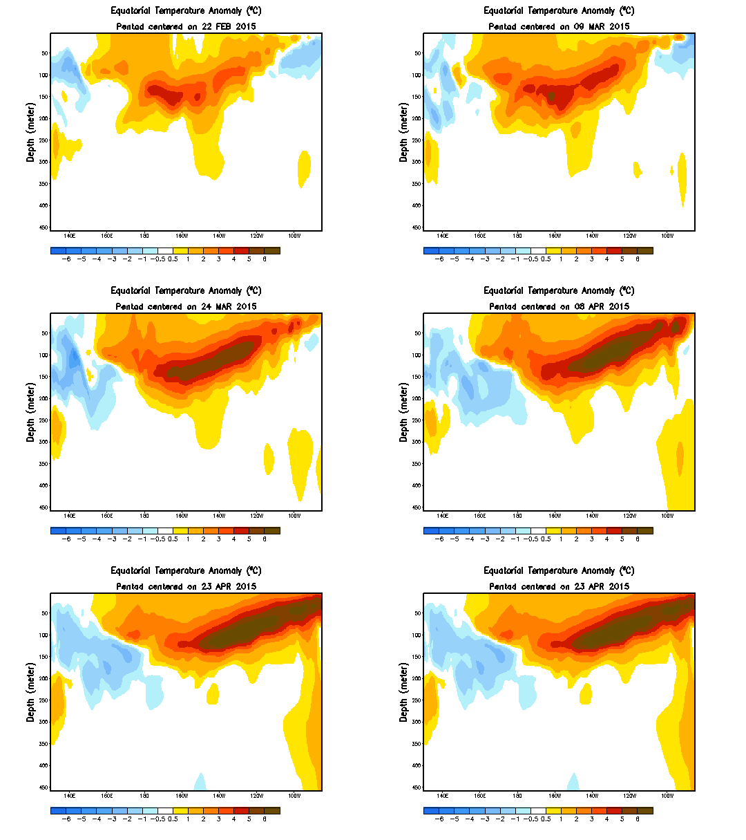
temperature anomalies in the Kelvin Wave plug have spread out across
the ocean surface. Readings in the range of +1 to +2 C above average
stretch along surface waters all the way from the Date Line through
120 West Longitude. East of the 120 line, surface waters have now hit
readings of 2 to 4 degrees Celsius above average. And lurking just
below the surface along thousands of miles of ocean is a dense zone
of 5-6 degree above average water. A zone of extreme heat at the
heart of the current intense Kelvin Wave:
(A
strong Kelvin Wave shuts down atmospheric heat transfer into the
Equatorial Pacific setting up conditions for an extended El Nino and
possible new record heat for 2015. Image Source: NOAA’s
Climate Prediction Center.)
Heat
that could well make 2015 yet another worsening of the human warming
and extreme weather twilight zone we now find ourselves in.
Pushing
into Moderate El Nino Range
According
to NOAA’s
weekly El Nino report,
sea surface temperatures in the critical Nino 3.4 region hit a range
of 1 degree C above average last week. A jump from the previous
week’s measure of +0.7 C and a new push toward moderately strong El
Nino levels off the back of the current warm Kelvin Wave. Atmospheric
teleconnections that are signatures of a moderate El Nino also began
to emerge over past weeks — with a strengthening of the subtropical
Jet and related storm track setting off powerful tornadoes,
thunderstorms and heavy rain events in states bordering the Gulf of
Mexico over the past ten days.
Heat
content from the current Kelvin Wave is enough to continue to keep
Equatorial Pacific sea surface temperatures in present ranges or to
push for further warming over at least the next 1-2 months. A set of
factors that will almost certainly lock near moderate El Nino
conditions in through Summer and general El Nino conditions through
early Autumn. The result is that the extra heat bleed off the Pacific
Ocean will combine with the impressive human forcing to generate a
high risk that 2015 atmospheric temperatures will beat out all-time
record highs set in 2014.
Model
Runs Still Showing Potential for Super El Nino
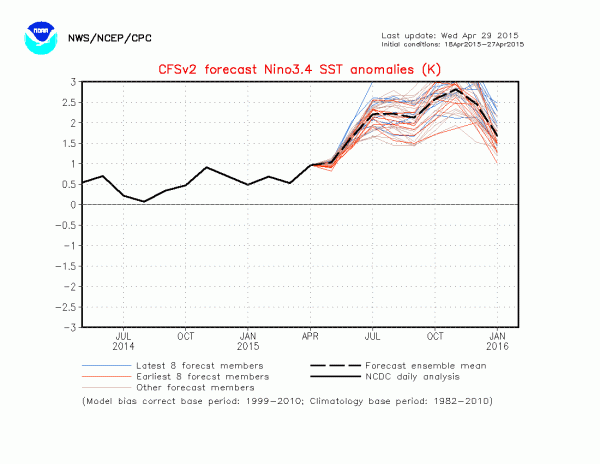
(Unweighted
model ensemble runs show the current El Nino peaking out at extreme
intensity. Long range model runs can be quite uncertain, but these
are very high values. Image source: NOAA
Seasonal and Monthly SST Anomalies.)
NOAA
model runs also show a potential for El Nino strengthening through
the end of 2015. Probability weighted CFS model ensembles (PDF) point
toward a seasonal anomaly for Nino 3.4 in the range of 1998 Super El
Nino values at 2.1 degrees Celsius above average by the end of 2015.
Mean model runs (non-weighted) push the long range forecast heat
values even higher at 2.6 C above seasonal averages or 2.75 C above
monthly averages.
These
unweighted long range forecasts are well outside the strength of even
the monster event of nearly two decades ago. An new super El Nino
that would have very serious consequences for global temperatures and
result in far-reaching climate impacts should it emerge. Atmospheric
temperatures that are now in the range of +0.7 C above 20th Century
averages and +0.9 C above 1880s values could well push into a new
range at +0.8 C and +1 C, or higher, respectively.
(Long
range models show Equatorial Pacific has potential to hit near Super
El Nino status by late 2015. At this time, such model runs are low
certainty. Image source: NOAA
Seasonal and Monthly SST Anomalies.)
Cranking
up the Human Hothouse
Entering
the range of 1-2 C above 1880s values is a zone of heat anomaly that
will amplify already apparent ice sheet melt, sea level rise,
droughts, wildfires, water stress, and ocean health impacts. At
temperatures around +1.5 C we begin to enter a period of strong
glacial outflows, weather instability, geophysical changes, and
record related storm events in a ‘Storms
of My Grandchildren‘
type scenario. At +2 C these very dangerous impacts will likely be in
full swing.
It
is worth noting that it took 10,000 years to warm the world 4 degrees
Celsius at the end of the last ice age. Under current human fossil
fuel burning scenarios, it is likely that we reach half that
threshold in just 150 to 170 years — from 1880 to 2030-2050. A
rapid reduction in fossil fuel emissions along a progression to a net
carbon negative human society over the next few decades is absolutely
necessary to prevent these outcomes. And while model forecasts
indicating the potential for a Super El Nino type event for late 2015
may be somewhat uncertain, there is a much higher certainty that very
dangerous climate impacts starting at the current level of human
warming will ramp up here on out — with the 1.5 C threshold looking
very bad and the 2.0 C threshold looking terrible.
As
such, we should do all we can to prevent hitting those marks.
Links:


No comments:
Post a Comment
Note: only a member of this blog may post a comment.