For source links see the original article
Eyewall
of Fearsome Cyclone Gita Churns across Tonga
Above:
Visible Himiwari-8 satellite image of Cyclone Gita just before sunset
(0140Z Monday, February 12, 2018). The islands of Tongatapu and ‘Eau
can be seen at far left. A satellite loop shows the storm pushing
west toward the islands. Image credit: RAMMB/CSU.
12
February, 2018
Thousands
of Tongans saw their most terrifying storm in living memory on Monday
night local time, as the eyewall of Tropical Cyclone Gita ripped
across the southern end of the Southwest Pacific archipelago under
cover of darkness. The eyewall of Gita passed directly over the
largest and most populous island, Tongatapu, which is home to the
nation’s capital, Nuku’alofa (population around 24,000).
Tonga
is a far-flung collection of 169 islands spanning roughly 500 miles
from north to south. On average, about one tropical cyclone a year
affects some part of Tonga, but Gita is by far the strongest on
record to make a direct hit on Tongapatu. The Joint Typhoon Warning
Center (JTWC) pegged Gita’s top winds averaged over a 1-minute
period at 145 mph, making it a Category 4 on the Saffir-Simpson scale
(or a Category 5 on the alternative scale used in the Southwest
Pacific). The central pressure of Gita as it approached Tonga was
estimated by the Fiji Meteorological Service to be 930 mb—even
lower than Hurricane Harvey when it struck Texas, as noted by Jon
Erdman (weather.com).
Enhanced
infrared satellite image of Cyclone Gita, 2/12/2018
Figure
1. Enhanced infrared satellite image of Cyclone Gita just after its
closest approach to the islands of Tongatapu and ‘Eua, which can
both be seen outlined just to the northeast of Gita’s eye. Gita
moved just to the north of due west as it passed just south of the
two islands. Image credit: NOAA/NESDIS.
Gita’s
westerly track and its intensification on approach (greater than
originally forecast) produced close to a worst-case scenario for
Tongapatu. The center of Gita’s eye passed only about 10-20 miles
south of the island. A saving grace is that Tongapatu was on the
weaker side of Gita’s eyewall, as winds rotate clockwise around
tropical cyclones in the Southern Hemisphere. In addition, Nuku’alofa
is located on the north side of the island, so its harbor was
shielded from any storm surge approaching from the south.
Nevertheless, we can expect widespread damage across Tongapatu, given
the strength of Gita.
A
Facebook page called Tonganow - Online Community for Tongans is
sharing initial damage photos, which include downed trees and power
lines and roof damage. Newshub (New Zealand) shared Facebook reports
of flooding at the Vaiola Hospital on the coast in Nuku'alofa.
Update: Tonga's Parliament House was destroyed by the storm.
Another
Tongan island, ‘Eua (population 5000), about 15 miles southeast of
Tongatapu, may have gotten an even more powerful hit, as the center
of Gita passed only a few miles to the south of ‘Eua. The harbor of
‘Eau’s main town, ‘Ohonua, sits on the west coast, so it would
have experienced the full force of the westerly winds on the north
side of Gita. The hilly terrain of ‘Eau likely worked to limit
storm surge, but the island no doubt got a pounding from Gita’s
high winds as well as heavy rains. Cat 6 commentor Jeremy L, who
visited the island recently, notes that the south side of the island
is quite exposed.
Monday’s
last observation from the Nuku’alofa airport—at 8:35 pm local
time Monday night, several hours before Gita’s closest approach to
the island—showed a wind gust to 63 mph. The Tonga Met Service
reportedly lost its roof and its access to radar data in the midst of
the storm. “From indoors, it’s like a soundtrack to a horror
movie out at sea,” tweeted Sulia Makasini, who had taken shelter at
a church on the island.
Our church hall #FWCFanga is filled with evacuees. The sense of security is overwhelming. The women and children are huddled in the higher and central parts of the hall. The men keep vigilant watch by the windows. If that isn’t love, I don’t know what is #proudTongan  #Tonga
 #Tonga
Track
of Cyclone Gita, Feb 2018
Figure
2. Gita carried out a multiday cyclonic loop on its approach to
Tonga, intensifying dramatically over the final 36 hours before
reaching Tonga’s southern islands. Gita brought high winds and
flooding rains to Samoa and American Samoa as it passed to their
south before rapidly intensifying. Image credit: Brendan Moses,
@cyclonebiskit.
Tonga’s
cyclone history
Although
Tonga’s wide north-south expanse makes it a prime target for
westward-moving tropical cyclones, the small size of each island
makes it quite unlikely that a major landfall will occur in any given
year. Two of the worst hits to Tonga in recent decades passed through
the Ha’apai island group, located in the middle of the Tongan
archipelago north of more populous Tongatapu.
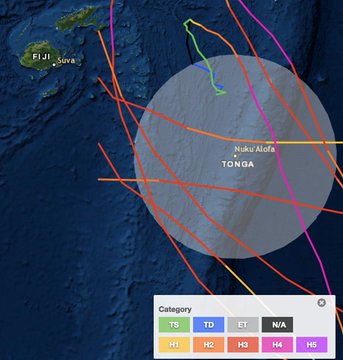
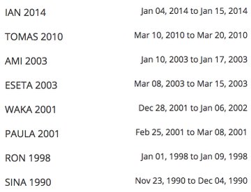
Cyclone
Ian (2014) is the only other Category 4 known to strike Tonga. Ian
packed top 1-minute sustained winds of 145 mph as it passed through
the Ha’apai islands. Ian decimated electrical and water supplies to
the islands, destroyed roughly 500 buildings, caused at least one
fatality, and left an estimated $48 million US in damage.
In
1982, Cyclone Isaac passed through the Ha’apai islands about 50
miles northwest of Tongatapu. Winds reached 106 mph at Nuku-alofa,
and damage was extensive across all three of Tonga’s island groups.
Isaac resulted in six deaths and left around 45,000 people homeless.
SST
anomalies over SW Pacific, 2/11/2018
Figure
3. Sea surface temperatures have been running more than 1°C (1.8°F)
above the long-term average over the area near and just south of
Tonga. This map shows departures from average SST for this time of
year, averaged on a weekly basis (here valid Feb. 11, 2018) and
compared to the 1961-1990 climatology. Image credit:
NOAA/NWS/NCEP/EMC Marine Modeling and Analysis Branch.
Unusually
warm waters fueling Gita
Sea
surface temperatures (SSTs) are typically near their warmest point of
the year in February across the Southwest Pacific. Right now these
waters are even warmer than usual in many areas (see Figure 3 above).
SSTs were in the range of 28-29°C (82-84°F) in the area that Gita
traversed as it neared Tonga, which is more than ample to support
tropical cyclone intensification.
Gita
appeared to be going through an eyewall replacement cycle late
Tuesday local time as it continued pushing westward across the
Southwest Pacific. As of 1500Z Monday (4 am Tuesday Tonga time), JTWC
continued to classify Gita as a Category 4 on the Saffir-Simpson
scale, with top winds of 145 mph. Gita is predicted to gradually
weaken as it arcs toward the west and eventually southwest. Gita
should bypass other major island groups from here on out, but the
storm or its remnants could bring very heavy rain to the North Island
of New Zealand in about a week.
Forecast
for Cyclone Gita, issued by JTWC at 15Z 2/12/2018
Figure
4. Forecast for Gita issued at 1500Z Monday, February 12, 2017 by the
Joint Typhoon Warning Center. Image credit: JTWC.
Tropical
Storm Sanba hitting the Philippines
The
first named storm of the 2018 typhoon season in the Northwest Pacific
is Tropical Storm Sanba, which formed on February 10 in the waters to
the east of the Philippines. Sanba peaked with 65 mph sustained winds
on Sunday, February 11. On Monday morning (U.S. EST), when Sanba was
approaching landfall in the southern island of Mindanao in the
Philippines, the system had weakened to a minimal-strength tropical
storm with 40 mph winds, thanks to moderate wind shear of 15 – 20
knots. Satellite loops showed that Sanba was disorganized but had a
large area of heavy thunderstorms, and the storm will bring dangerous
flooding rains to the southern portion of the Philippines through
Tuesday.
TS
Samba approaching the Philippines, 2/12/2018
Figure 5. Tropical Storm
Sanba approaching the Philippines as seen by the VIIRS instrument on
NOAA’s Suomi satellite at 05:12 UTC February 12, 2017. Image
credit: NASA.
The
development of both Sanba and Gita was aided by the Madden-Julian
Oscillation (MJO), a pattern of increased thunderstorm activity near
the Equator that moves around the globe in 30 - 60 days. When the
area of increased thunderstorms associated with the MJO is located in
the Western Pacific, formation odds of a tropical storm increase. The
current MJO pulse is starting to wane, but during its peak on January
30, it was the strongest Western Pacific event since MJO records
began in 1979. Note that the previous record-strength MJO events in
the region, in March 1997 and March 2015, occurred during the lead-up
to record-strength El Niño events later in those years. It is
possible that this year’s record-strength MJO event could also help
lead to an El Niño by the end of 2018.
Sanba
the second tropical storm to hit the Philippines in 2018
While
Sanba is the first named storm to form in 2018 in the Northwest
Pacific, it is the second tropical storm to hit the Philippines this
year. The islands were also hit this year by Tropical Storm Bolaven,
which made landfall in Mindanao on January 1, killing three people
and doing approximately $11 million in damage. Bolaven formed on
December 30, 2017, though, and thus belongs to the 2017 typhoon
season. According to archives of Northwest Pacific tropical cyclone
activity maintained by Dr. Phil Klotzbach (Colorado State), the
Northwest Pacific averages one named storm every two years by this
point in the season.
Dr.
Jeff Masters contributed to this post.


No comments:
Post a Comment
Note: only a member of this blog may post a comment.