Dorian
to hit Bahamas as
'devastating' hurricane, then
menace Georgia and
Carolinas
31
August, 2019
JACKSONVILLE,
Fla. (Reuters) - Hurricane Dorian punched northwest on Saturday to
threaten Georgia and the Carolinas, possibly sparing Florida a direct
hit, as the Bahamas braced for catastrophic waves and wind from the
muscular category 4 storm.
Florida
towns told residents to remain vigilant despite forecasts they might
dodge a Dorian landfall, as a tropical storm watch was issued for the
state’s south Atlantic coast.
RELATED
COVERAGE
After
Dorian takes a turn, central Florida city breathes sigh of relief
Communities
in northeast Florida, Georgia and South Carolina raised alert levels,
with residents filling sandbags as authorities tested infrastructure
and hurricane drills. South Carolina on Saturday joined Georgia,
North Carolina and Florida in declaring a state of emergency.
Bahamas
Prime Minister Hubert Minnis begged residents of Abaco and Grand
Bahamas to head for the main island to escape the “devastating,
dangerous” storm.
“I
want you to remember: homes, houses, structures can be replaced.
Lives cannot be replaced,” Minnis told a news conference, adding
that 73,000 people and 21,000 homes were at risk to storm surges of
up to 15 feet (4.6 meters).
At
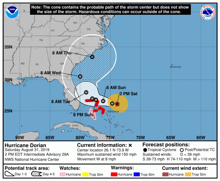
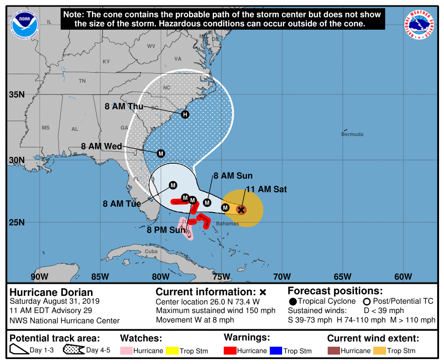
5 p.m. ET (2100 GMT)The National Hurricane Center (NHC) said Dorian
was packing maximum sustained winds of 150 mph (240 kph) and would
hit the Bahamas on Sunday with more than two feet of rainfall in
places, threatening deadly flash floods.
Dorian
could then veer northwest and possibly remain at sea as it moved up
the U.S. eastern seaboard late on Monday through Tuesday, the NHC
said.
A
tropical storm watch was issued for a more than 120-mile stretch (193
km) of Florida coast from Deerfield Beach to around Palm Bay, meaning
sustained winds of up to 73 mph (117 kmh)were possible within 48
hours.
North
Carolina authorities warned residents Dorian was heading their way,
while counterparts in Florida told towns to remain alert.
“While
obviously for us it’s a better forecast, we can’t assume that
there’s not going to be hazardous weather,” said Miami Beach
Mayor Dan Gelber.
BAHAMAS
ON SUNDAY
Central
Florida towns urged residents to remain alert after past hurricanes
like 1992’s Andrew slammed the Bahamas and then barreled straight
into the peninsula’s southeast coast.
“Don’t
start taking down your shutters, don’t start disassembling your
emergency plan,” said Eric Flowers, a spokesman for the sheriff’s
office in Indian River County.
“Our
biggest concern is storm surge because the tides are really high
right now,” said the manager of a local restaurant, who asked not
be named as he was not authorized to speak to media.
Further
north, Dorchester County in South Carolina raised its alert level to
make sure infrastructure and public safety crews were ready for the
hurricane in the area near the historic city of Charleston.
North
Carolina Emergency Management (NCEMA) said the storm was forecast to
keep moving in the state’s direction for the next 48 hours.
“Now
is the time to prepare and assemble disaster supplies,” said Katie
Webster, an NCEMA meteorologist, urging people to prepare a week’s
supply of food and water.

CATEGORY
5! 161 MPH
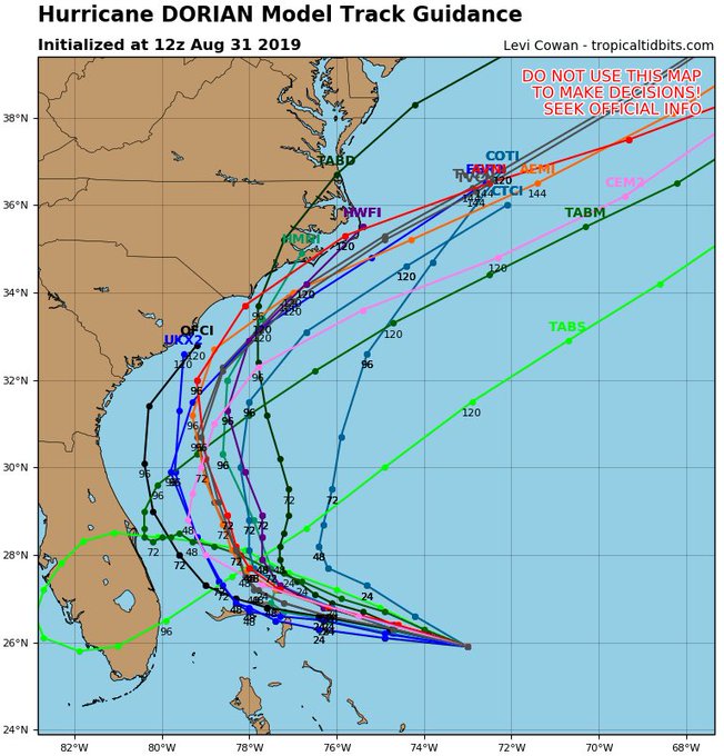
As of 10:40 AM EDT Saturday, August 31, Hurricane Dorian has strengthened to a Category 5 Hurricane, the highest rating, with maximum sustained winds of 158 MPH. Trouble is, the computer models have NO IDEA which way this storm is going. They disagree if there will be landfall in Florida, Georgia, or South Carolina. The models now seem utterly USELESS. The literal Spaghetti model (above) is probably more accurate . . .
Take a look at the diverging computer models:
And another . . .

But this other model severely disagrees:
And this one disagrees with all the rest . . .
and another . . .
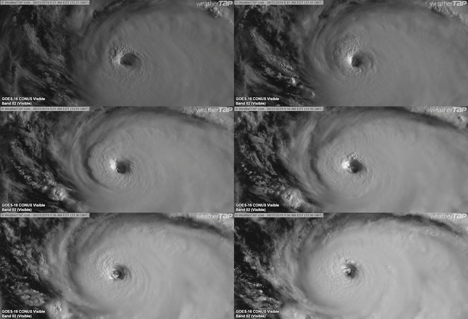
Wherever it ends up going, this storm is a MONSTER:
As of 10:58 AM EDT, the storm is now beginning to move over extremely warm surface waters. It will pick up strength from that heat.
But the storm is between two High Pressure Systems, one to its northeast, the other to its south. Those high pressure systems are forcing the hurricane west.
The High pressure system to the north is moving slowly eastward, which may open a lower pressure path northward IF it moves fast enough and IF the hurricane moves west enough. It's a friggin guessing game right now and at-stake are the lives and property of MILLIONS of people in Florida, Georgia, South Carolina and elsewhere.
Weak steering currents & stalling storms should never be trusted.
With 72 hours before Dorian turns north, even a 1 mph error in the storm's speed until then could result in a 72 mile error in how far west Dorian gets.
Stay vigilant. More changes could occur. It's a tough one.
With 72 hours before Dorian turns north, even a 1 mph error in the storm's speed until then could result in a 72 mile error in how far west Dorian gets.
Stay vigilant. More changes could occur. It's a tough one.
As of now, the only thing certain is the storm is terrifyingly powerful and wherever it goes, someone is going to have a very big problem. Those in the southeastern US MUST have hurricane preparations.
This storm could go anywhere and if it comes at YOU, you'd better be ready.
And you may want to think twice about paying much attention to the National Hurricane Center projections. The 1-Minute video below shows how wide-ranging and INaccurate their computer models for this storm have actually been!
Sure, we'd all LIKE to be able to rely on them. But truth is, we only know two things: There's a major hurricane coming at us, AND;
The people we pay to track these things seem to have very little idea where it's going.
For Instance The last few ECMWF ensemble cycles continue slowing down Dorian's track, w/ an increasing # of members showing a SW motion in the Bahamas.
A direct Florida landfall is still very possible.
A direct Florida landfall is still very possible.
We're on our own. Prepare.
UPDATE 1:29 PM EDT --
South Carolina Gov. Henry McMaster declares State of Emergency to prepare for potential impact from Hurricane
UPDATE 1:54 EDT --
Hurricane Hunter aircraft now confirm surface wind speeds of 161 MPH sustained. Category 5
UPDATE 2:10 PM EDT --
Mayor Francis Suarez signs emergency declaration for City of Miami for Hurricane
UPDATE 4:50 PM EDT --
Tropical Storm Watch has been issued for the east coast of Florida from Deerfield Beach to Sebastian Inlet.
UPDATE 5:00 PM EDT --
National Hurricane Center shows Florida quasi-hit (again) in latest warning cone


Hey liked your post i have similar post on my blog. This is link to it
ReplyDeletehttps://ironicalcreation3.blogspot.com/2019/09/hurricane-dorian-bahamas-us-flooding-florida-south-north-carolina.html