Cyclone Gita's eye grows even larger, now over 100km wide
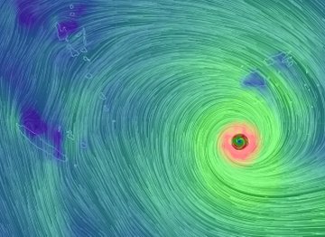
Cyclone Gita's eye has grown even larger, NIWA warns - and it is heading towards New Zealand.
15
February, 2018
The
devastating storm is moving away from Fiji and feeding off the warm
water.
"Tropical
#CycloneGita's eye has grown substantially since yesterday and now is
over 100 km wide -- that's larger than average," NIWA says on
Twitter.
Tropical #CycloneGita's eye has grown substantially since yesterday and now is over 100 km wide -- that's larger than average.
While
the eye might be larger, due to its energy being spread over a larger
area, it will likely be weaker.
#CycloneGita 4pm Update: Central Air Pressure 928HPA, still Category 5. Storm now over open waters moving slowly away from #Fiji area. Cyclone moving W at 9 knots, likely turning WSW tonight. Weakening expected next few days.
However
it is still expected to bring heavy rain and howling winds to our
country.
"Rain
impacts in NZ related to Gita may arrive as early as Monday but peak
on Tuesday-Wednesday," NIWA says.
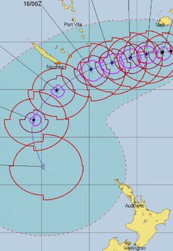
#CycloneGita: Latest possible tracking into #NewZealand next week (+6 Maps) weatherwatch.co.nz/content/cyclon… via @weatherwatchnz #weather #storm
#CycloneGita
MetService have issued a blog with the history & future track of #TCGITA. You can find it at bit.ly/TCGITA_1
This system will likely impact New Zealand early next week, but there is considerable uncertainly regarding the track as it approaches us. ^Lisa
MetService
is maintaining a Gita
blog so New Zealanders can track the cyclone's
progress
There
are several possibilities for where Gita could hit, with modelling
showing the area of impact to be anywhere from the top of the North
Island to the middle of the South Island.


No comments:
Post a Comment
Note: only a member of this blog may post a comment.