California will burn until it rains — and climate change may keep future rains away
Dry
weather looms ahead as fires rage across Southern California
/cdn.vox-cdn.com/uploads/chorus_image/image/57880155/886767680.jpg.0.jpg)
6
December, 2017
Wildfires
are spreading unchecked across Southern California, adding more
infernos to the state’s worst
fire season on record. A warm, dry fall in Southern California
and strong offshore winds combined to create dangerous fire
conditions that
will probably get worse. As the winds
continue to blow, a dome of warm, high-pressure air is forming
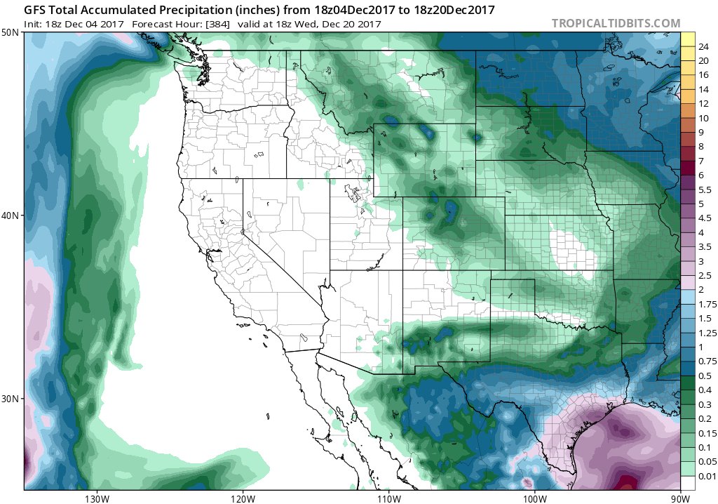
over the West Coast that could keep California dry and flammable for
weeks to come.
The
largest fire burning in Southern California started in the foothills
of Ventura County on Monday evening. Called the “Thomas fire,” it
spread overnight to burn more
than 65,000acres, jumped the 101 freeway, and was stopped only by
the Pacific Ocean, the LA
Timesreports.
Four more fires are raging from
San Bernardino to Santa Clarita.
Hot,
dry winds blowing
up to 70 miles per hour across Southern California are
fanning the flames, but those
aren’t unusual for December, says Daniel
Swain, a climate scientist at the University of California Los
Angeles and writer of the Weather
West blog.
Called the Santa Ana winds, these southern counterparts to Northern
California’s Diablo winds tend to kick up during the fall and
continue through the winter.
But
something unusual is happening:
Southern California’s warm winter dry spell, Swain says. “By this
time of year, usually, there’s been some rain that’s wetted
things down,” he says in a telephone interview, speaking over the
Santa Ana winds howling in the background. “It’s just as dry as
it was in the summer months.”
California
gets most of its rain between October and May from storms that roll
in from the Pacific, riding a highway of strong winds in
the upper atmosphere called the jet stream. By now, LA
should have been sprinkled by about two inches of rain, National
Weather Service meteorologist John Dumas told the LA
Times.
But so far it’s only seen about 5 percent of that, amounting
to about
one-tenth of an inch. Burbank, California, has seen even less,
says National Weather Service meteorologist David Sweet. Despite the
rain that’s been showering Northern California, the
bottom part of the state is abnormally dry; certain areas are
even experiencing a moderate drought. “We’re quite parched,”
Sweet says.
- Pinned TweetSpecial post on the Weather West blog: deep dive into our new research on the #RidiculouslyResilientRidge and the North American Temperature Dipole. Focuses on work by @ClimateChirper @danethanNU @jsmankin @Weather_West (and others). #CAwx #CAdrought

Storms
in the jet stream can get diverted by high-pressure bubbles of warm
air. A version of this phenomenon called an "atmospheric ridge"
is to blame for Southern California's current dry spell. And even
even bigger one has started forming along the entire West Coast of
the US that could shunt rainfall into Canada or Alaska, Swain
writes. “We were dry before and now the prospects for rain look
even less likely because of the size of this thing,” Sweet says.
This
is the same atmospheric phenomenon that squatted over the state for
three winters in a row during California’s record-setting,
five-year drought. “The real question is how long it persists,”
Swains says. During the drought, these ridges lasted for months at a
time — but we don’t know what’s in store for this new one. Even
worse news: these atmospheric ridges are getting more common —
possibly thanks to human-caused global warming, Swain and his
colleagues reported
in a 2016 study.
And
they could become even more frequent
in the future as the polar ice melts, new research says. Scientists
led by Ivana
Cvijanovic at Lawrence Livermore National Laboratory modeled
how dwindling Arctic sea ice could affect the global climate over the
coming decades. They found that as the sea ice melts, the Arctic
warms — starting a chain reaction that ultimately helps these
atmospheric ridges form over the North Pacific, blocking rain from
falling on California. That doesn’t just make drought more common,
it’s also possible that it could also make fire seasons last
longer.
The
findings, described in a new study published Tuesday in the
journal Nature
Communications,
are a hint of what’s to come — but they’re not a prediction of
the future, Cvijanovic cautions. Other shifts in air pollution,
greenhouse gasses, and even volcanic activity over the coming decades
could also change how much rain falls on California. (In
fact, another
recent study suggests climate change could make California
wetter.)
What’s
clear for now is that the dry, windy weather forecast for Southern
California means that the firefighters struggling to stop the flames
have a long battle ahead of them. “The fire season in Southern
California stops when you get enough rain that everything gets wet
and turns plump and green,” says Bill Stewart, a forestry
specialist at UC Berkeley. “That’s the only thing that’s going
to change the system down there.”


No comments:
Post a Comment
Note: only a member of this blog may post a comment.