Record
Warm World’s ‘Weird’ 2015 El Nino Sees Westerly Gales, Growing
Kelvin Wave
12
March, 2015
And
the current El Nino is certainly an odd bird. According to reports
from NOAA and
theNational
Weather Service,
the center of highest sea surface temperatures for the El Nino this
year is offset westward — coming closer to the date line than it
typically does. This is a weird heat disposition for El Nino which
is, at least, a mid ocean event and often pushes warming well across
the Pacific to South American shores.
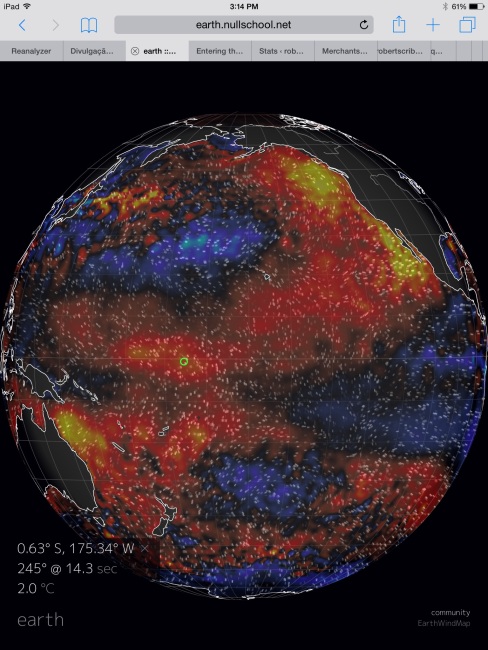
(Pacific sea surface temperature anomaly [SSTA]. Note the hot water pools off both Australia and North America. These zones are joined by a vast blanket of warmer than average waters arranged diagonally across the Pacific from SW to NE. This disposition includes the warm anomaly along the Equator which is hot enough to reach weak El Nino status. But the disposition of sea surface temperatures throughout the Pacific, with highest equatorial anomalies near the date line and warmer spikes near Australia and the North American West Coast is unusual. SSTA graphic provided by Earth Nullschool. Data Source: Global Forecast System Model and NCEP.)
It’s
also late in coming, as typical El Ninos have tended to arrive in
full form during late fall or early winter. A Christmas-time warming
of waters off the West Coast of South America was a traditional
call-sign for El Nino and one that resulted in its name — which is
Spanish for “The Christ Child.” Late winter and early spring are
more typical times for the formation of deeper warmer water that may
trigger an El Nino later in the year but often do not herald a
fully-developed event (see What
is El Nino? for
more related information).
Lastly,
the El Nino is currently rather weak — barely meeting
a requirement for El Nino from NOAA and
still not reaching the threshold that Australia’s
Bureau of Meteorology applies.
But
despite all this relative oddity, the 2015 El Nino is here. And it
appears to be growing.
Intense
West Wind Back-burst Coincident with Powerful Cyclone Formation
For
earlier this week strong westerly winds began to roar against the
typical flow of the trades along the Equator. The west wind
back-bursts (WWB) push warmer West Pacific waters eastward and
downward, enhancing the sea surface temperature anomaly spikes that
fuel El Nino.
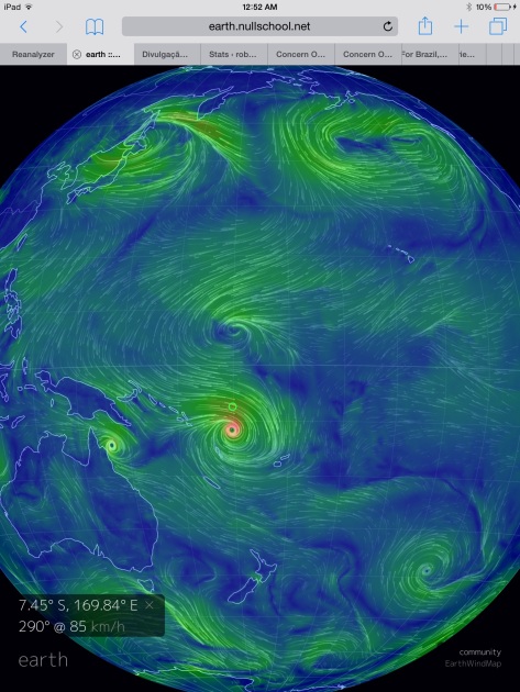
(Very strong West Wind Back-Burst hosting 85 kph 10 minute west wind at 7.45 South Latitude on early March 11. Image source: Earth Nullschool.)
As
of early Wednesday, March 11, these west winds had formed a gale
force wall stretching just past the date line from about 5 North
Latitude to 10 South Latitude.
A gale driven by parallel cyclones —
a weaker system to the north (Bavi) and the newly gathering Pam,which
may challenge south Pacific records as the strongest storm ever to
form in that region.
In the above graphic we see a related ten minute sustained WWB of a
rather extraordinary 85 kilometers per hour (about 50 mph) along the
7.45 degree South Latitude line.
Strengthening
Kelvin Wave in a Record Warm World
Just
before the formation of these strong westerlies, sub-surface
temperatures also began to spike. A warm Kelvin wave that had already
started its run beneath the sea surface, as of March 4, was beginning
to show signs of strengthening well in advance of the added shove
coming from the vigorous WWB shown above.
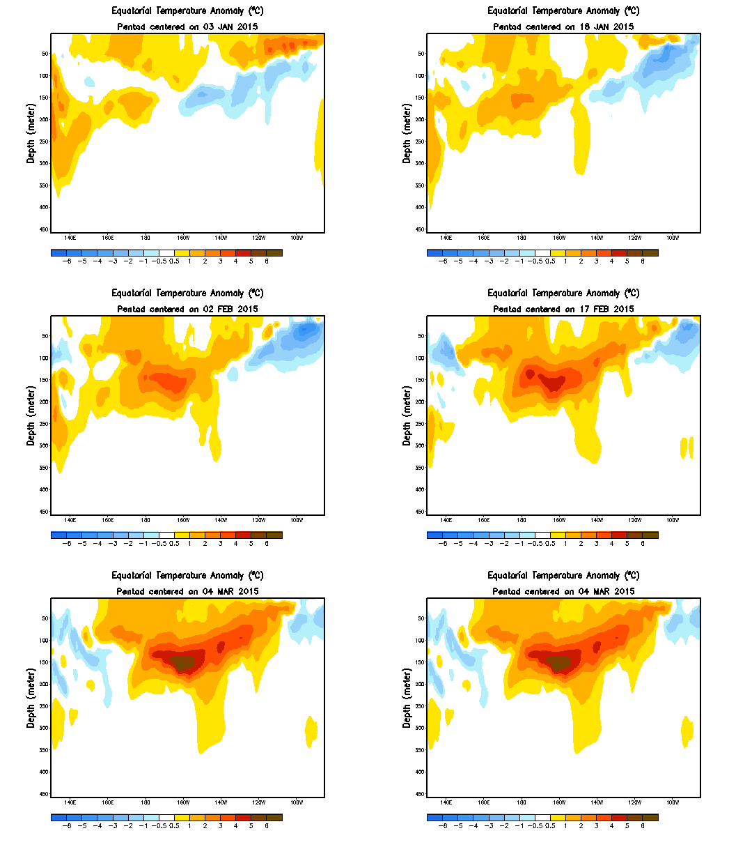
(A new Monster Kelvin wave? Sub surface temperature anomalies are again entering the far above normal range for the Equatorial Pacific. Image source: Climate Prediction Center.)
Peak
temperatures in the wave as of a week ago had hit more than +6 C
above average. A heat signature that is starting to look, more and
more, like the very powerful Kelvin Wave of early 2014 that belched
so much warmth into the atmosphere and likely contributed to both the
current strongly positive PDO as well as 2014’s new record high
temperatures.
An
event that top ocean and atmospheric scientists Kevin
Trenberth and Axel Timmerman attribute to signalling a possible start
to much more rapid atmospheric temperature increases.
If
this is the case, then what we may be seeing is a slow start to an El
Nino that could be much stronger and longer than expected. Last
year’s intense Kelvin Wave may have simply been preparation for a
slowly building event in conjunction with what was, during
December, a
record broader warming of the Pacific called positive Pacific Decadal
Oscillation (PDO).
Some model runs, especially those
at Australia’s BoM, appear to have picked up this track.
For
this reason, our ‘weird’ El Nino and equally weird and warm
Pacific bear close watching.
Links:
Hat
tip to Phil
Hat
tip to Wili


No comments:
Post a Comment
Note: only a member of this blog may post a comment.