U.S. Northeast Battered by Second ‘Once in a Generation’ Storm This Year
2
March, 2018
A
major nor’easter is lashing the Eastern U.S. today.
Reports of moderate to severe tidal flooding are racking up as
hurricane force gusts are pushing mounds of water inland and raking
the coastline with tremendously powerful waves.
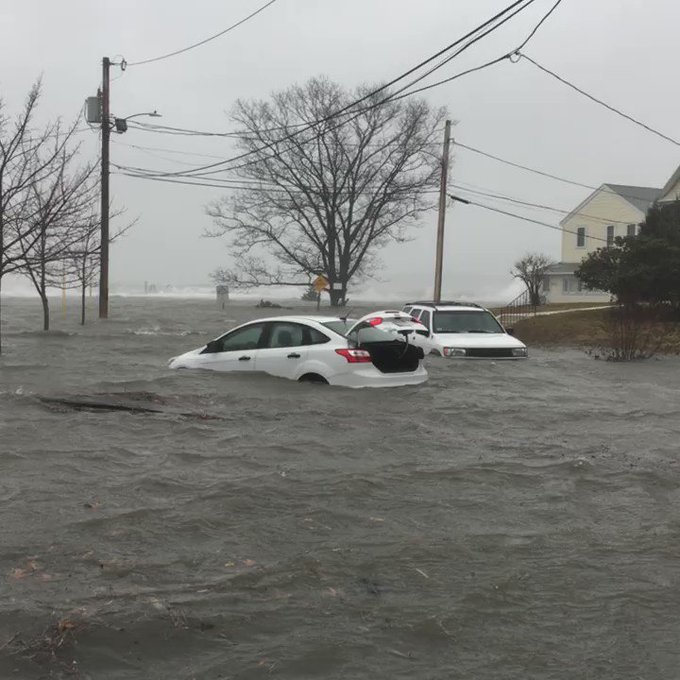
The waves hitting Scituate today are higher than the roof on a two-story house. Worst flooding still to come tonight
This
storm blew up to extreme intensity over the night-time and early
morning hours on Friday as two low pressure cells converged off the
U.S. coast. By afternoon, the
storm had bombed out to 970 mb and was still intensifying.
A
broad region across the northeast from D.C. to Maine are now
experiencing wind gusts of 50 to 80 mph or more with local power
outages and downed lines reported over a broad region. The gusts are
so strong and widespread that diverse locations all throughout the
Northeast are seeing instances of toppled trees, damage to structures
and falling limbs. In Chambersburg, PA, the
raging gusts tipped over a school bus.
On
the coast, extremely strong winds for a nor’easter and conditions
more akin to a hurricane are driving directly in to shore from
Chatham and Nantucket northward. As a result, weather authorities are
predicting a historic coastal flood event for metropolitan areas like
Boston. There, record
high tides may be exceeded as winds there are now blowing at a
vicious 80 mph.
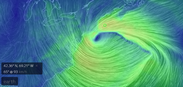
(A
broadening storm is lashing most of the Northeastern U.S. with gale
and hurricane force winds even as a places like Boston face massive
waves and record storm surge flooding. Image source: Earth
Nullschool.)
But
what is, perhaps, more concerning is the fact that this storm is
still gathering strength. And due to a blocking high over Greenland,
the storm — dubbed Riley — is likely to only slowly move
off-shore. So its impacts will tend to persist for multiple high tide
cycles even as its circulation broadens and it generates an
east-to-west fetch of gale to hurricane force winds stretching over a
400 to 600 mile region of ocean and driving directly toward the
Northeast and East Coasts.
This
will enable a long-lasting storm surge that will generate serious
flooding for hundreds of miles of coastline. And on top of that
surge, towering waves will relentlessly batter the coast throughout
Friday and Saturday. Already the flooding has become quite severe for
a number of locations. But the situation is likely to get worse
before it gets better. With the worst impacts expected at high tide
late tonight.
Scenes
like these bring back recollections of Sandy. And like Sandy, the
present cyclone has been influenced in a number of ways by
human-caused climate change.
The
storm’s historic intensity was first fed by a large plume of
moisture issuing off a much warmer than normal Gulf of Mexico.
Instability, driven by a deep diving trough, formed a low sweeping
over the north-central U.S. that then tapped this high volume of
moisture. The latent heat in the moisture enabled stronger than
normal convection which helped to spike the storm’s early
intensity.
(Extremely
warm sea surface temperatures both in the Gulf of Mexico and off the
U.S. East Coast are helping to fuel the present storm’s record
intensity. This is just one of the climate change associated factors
contributing to the present storm. Image source: Earth
Nullschool.)
Off shore, the Gulf
Stream waters are also far warmer than normal. Ranging as high as 9
degrees Celsius above average, this abnormal heat helped to fuel a
second plume of moisture and instability. And as these two areas of
storminess merged, they rapidly bombed out to high intensity even as
their area of storm wind circulation broadened.
To the north, a recent
(climate change driven) polar warming event has generated a kind of
train wreck in the upper level winds that typically hurry storm
systems along. As a result of this train wreck, a blocking high over
Greenland is preventing this heat-amplified storm from tracking
eastward. Over the next 48 hours, this block will allow a massive
pile of water and towering waves to relentlessly hammer the
Northeastern and Eastern Coasts of the U.S.
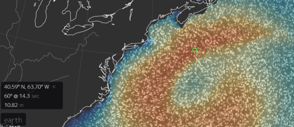
(Large
waves and long fetch which is predicted to be generated by this storm
on Saturday could produce serious and wide-ranging impacts all up and
down the Eastern Seaboard from Hatteras to Portland and points
northward. Image source: Earth
Nullschool.)
Presently,
this storm is expected to produce the
second 1 in 100 year flood event that
the Boston area has seen in the past year. Under typical climate
variability, the likelihood of seeing back-to-back events of this
kind would be 1 in 10,000. However, due to the influences of
human-caused climate change, the potential for extreme weather events
like the one we are presently enduring are greatly enhanced.
(UPDATES TO FOLLOW)


No comments:
Post a Comment
Note: only a member of this blog may post a comment.