I think there is an element of the unprecedented and Hal Turner may be right. The authorities may be lost and making it up as it goes along.
I would listen to the forecasts but by no means be dependent on them.
HURRICANE
HAS **NOT** TURNED; STILL HEADING TO FLORIDA
2 September, 2019
For DAYS, so-called weather "experts" and their nifty computer "models" have told us that Hurricane Dorian would turn to the north and go out to sea, missing Florida. It hasn't done that. Because of horrible forecasting, many Floridians went to bed last night thinking very little about this storm and are now waking up to a full blown Cat5 Hurricane on their doorstep.
Hurricane Warnings have now gone up for many Florida Counties and EVACUATIONS are being ordered.
As of 8:00 AM EDT Monday, September 2, Hurricane Dorian is still moving WEST toward Florida, now at 1 MPH.
Dorian is now tied for second-strongest Atlantic hurricane ever.
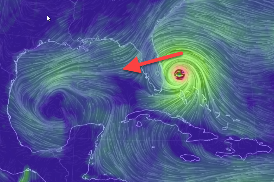
For those that can't comprehend, here it is: the blue arrow is what it should be doing according to the EURO, GFS, NAM, and the other 5 models NOAA is using. The pink arrow is what Hurricane Dorian is actually doing:

Behind closed doors the forecasters are confounded. They appear to some people to have made some mistakes interpreting the early data and that resulted in bad models. But instead of admitting their oversights and correcting the models with better data, they are crossing their fingers hoping their bad predictions come true anyway. The truth is they don't know because Dorian has broken so many known patterns of behavior.
The "down and dirty" of this situation is that to even untrained casual observers, it appears Dorian is not going to turn until after it makes landfall in Florida. The models are wrong... NOAA is using the same models that failed to predict Maria and Irma correctly.
Dorian isn't gonna turn. Here are the upper level "steering winds" and you can plainly see the white line immediately atop Dorian is moving . . . . WEST!
It was supposed to be heading north of Grand Bahama by now but instead he's moving straight down the island with a slight -south- of west component instead.
If we were in Palm Beach or anything 50 miles north or south of there then we'd be getting worried right about now.
Boca Raton, Delray Beach, Boynton Beach, Lake Worth, West Palm Beach - It's got you in its sights!
A category 5 going straight west into West Palm Beach is a likely scenario now.
Here's how close the storm is to Florida as of Midnight eastern US time:
Here's the actual measurement:
MODELS WAAAAYYYY OFF
To give you an idea of how "off" most of the computer models have been, the image below takes the GEFS models the weather experts have been using, and overlays the ARCHER actual satellite positioning. Most of the "models" have been very inaccurate:
Hurricane Dorian Tropical Cyclone Update
NWS National Hurricane Center Miami FL AL052019
700 AM EDT Mon Sep 02 2019
...EYE OF DORIAN DRIFTING WESTWARD...
...DESTRUCTIVE HURRICANE FORCE WINDS BATTERING GRAND BAHAMA
ISLAND...
This is a life-threatening situation. Residents on Grand Bahama
Island should not leave their shelter when the eye passes over, as
winds will rapidly increase on the other side of the eye. Residents
in the Abacos should continue to stay in their shelter until
conditions subside later today.
Hazards:
- Wind Gusts to 200 mph
- Storm Surge 18 to 23 feet above normal tide levels with higher
destructive waves
These hazards will continue over Grand Bahama Island during most of
the day, causing extreme destruction on the island.
SUMMARY OF 700 AM EDT...1100 UTC...INFORMATION
----------------------------------------------
LOCATION...26.7N 78.2W
ABOUT 35 MI...50 KM ENE OF FREEPORT GRAND BAHAMA ISLAND
ABOUT 120 MI...190 KM E OF WEST PALM BEACH FLORIDA
MAXIMUM SUSTAINED WINDS...165 MPH...270 KM/H
PRESENT MOVEMENT...W OR 280 DEGREES AT 1 MPH...2 KM/H
MINIMUM CENTRAL PRESSURE...916 MB...27.05 INCHES
SUMMARY OF 1100 AM EDT...1500 UTC...INFORMATION
-----------------------------------------------
LOCATION...26.8N 78.3W
ABOUT 30 MI...50 KM NE OF FREEPORT GRAND BAHAMA ISLAND
ABOUT 110 MI...180 KM E OF WEST PALM BEACH FLORIDA
MAXIMUM SUSTAINED WINDS...155 MPH...250 KM/H
PRESENT MOVEMENT...W OR 280 DEGREES AT 1 MPH...2 KM/H
MINIMUM CENTRAL PRESSURE...922 MB...27.23 INCHES
Evacuation info and additional reporting pending shortly, check back for updates below . . . .
UPDATE 10:00 AM EDT --
The image below was taken at 9:31 AM and shows the hurricane still spinning over the Bahamas AND GROWING IN SIZE! Watch and you can see the wind field expanding dramatically:
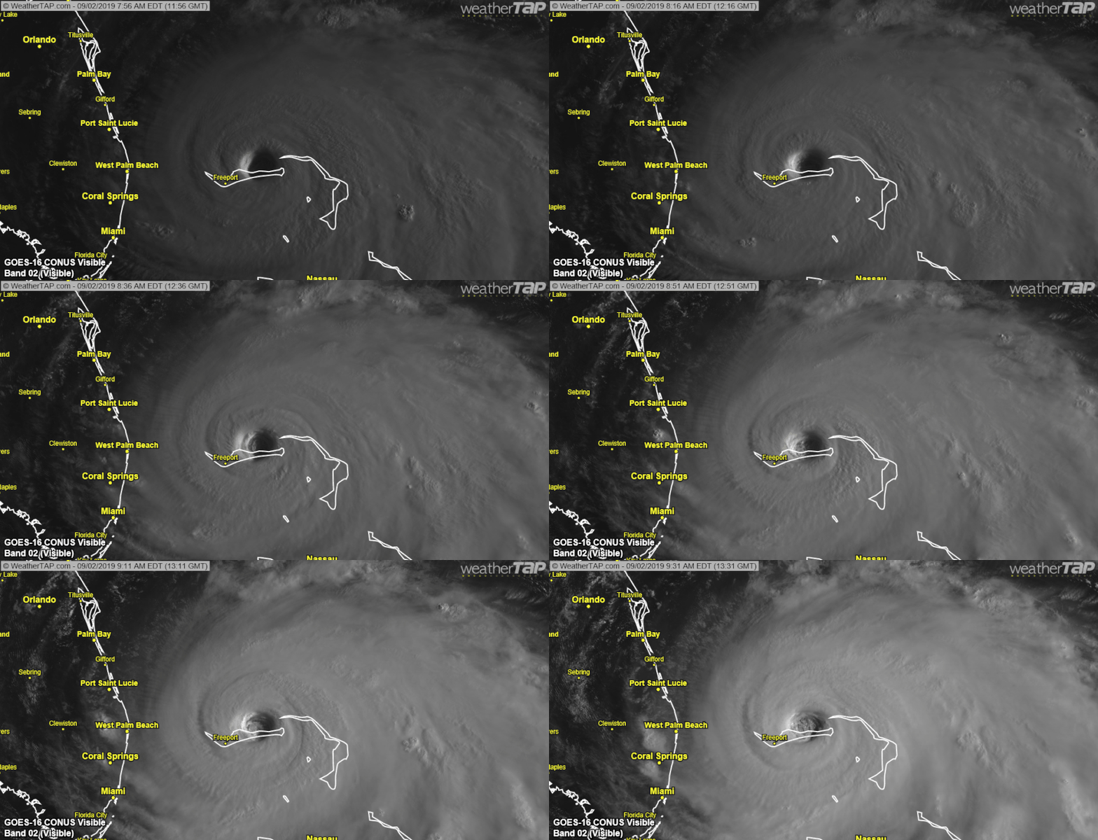
You can also see the storm is **NOT** moving north.
As of 10:00 AM, folks in Florida still have time to evacuate if they leave very soon. The wind speeds of this storm are still between 165 and 185 Miles per hour. Confirmed gusts to 200 MPH. If this storm starts moving west again, YOU could face those winds and wind gusts; YOU would lose.
If you wait to evacuate, and the storm begins to move, then YOU and EVERYONE ELSE will be trying to flee at the same time. If you leave early, you have much better chances.
UPDATE 1:45 PM EDT --
A sustained wind of 40 mph with a gust up to 48 mph was observed at Juno Beach Pier at 12:59. This is the first sustained tropical storm force wind observed in South Florida from Dorian.
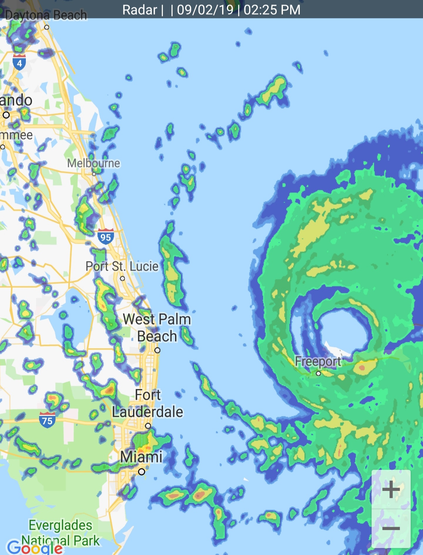
UPDATE 2:25 PM EDT --
Here is a snapshot of the weather radar from Miami:
FLORIDA
STATE PREPAREDNESS ACTIONS
WATCHES AND WARNINGS
- A Hurricane Watch has been issued for the East Coast of Florida from north of Deerfield Beach to the Volusia/Brevard County Line.
- A Storm Surge Watch has also been issued from north of Deerfield Beach to the Volusia/Brevard County Line.
- A Tropical Storm Watch has been issued for Lake Okeechobee.
- The Hurricane Warning along the east coast of Florida has been extended northward to the Flagler/Volusia County Line.
- The Storm Surge Warning has been extended northward along the east coast of Florida to the Flagler/Volusia County Line.
- NEW 5:22 PM EDT -- Hurricane Warning has been extended northward to Ponte Vedra Beach, Florida.
EVACUATIONS
The following counties have issued mandatory evacuations:
- Martin County – Mandatory evacuation order for Zone A and Zone B are in effect. This includes Hutchinson Island, Jupiter Island, Sewall’s Point, low lying areas, and mobile and manufactured homes.
- Palm Beach County – Mandatory evacuation order for Zone A and Zone B. Zone A includes mobile homes, sub-standard housing and low-lying areas prone to water intrusion. Zone B includes the barrier islands, land areas north and south of the Jupiter Inlet, and other surge-vulnerable areas south along the Intracoastal Waterway to the Broward County line.
- Brevard County – Mandatory evacuation order is being issued at 5 p.m. today for Zone A, including all mobile and manufactured homes.
- St. Lucie County – Mandatory evacuation order for residents on the barrier island (North and South Hutchinson Island), those living in low-lying coastal areas and mobile homes.
- St. Johns County – Mandatory evacuation order is being issued at 8 a.m. on Monday, September 2 for Zone A and Zone B, which includes the entire cities of St. Augustine and St. Augustine Beach, and those living on waterfront property or in flood-prone areas.
- NEW 11:00 AM EDT -- Mandatory evacuations have been ordered in Duval County for Zones A and B. It's getting serious
- The following counties have issued voluntary evacuations:
- Osceola County – Voluntary/Phased
- Glades County – Voluntary/Phased
- Hendry County – Voluntary/Phased
- Indian River County – Voluntary/Phased
- Okeechobee County – Voluntary/Phased
- Highlands County – Voluntary/Phased
- More information on evacuations can be found at www.floridadisaster.org/info.
TELECOMMUNICATIONS
- To help residents and emergency personnel stay connected in the wake of Hurricane Dorian, Comcast has announced it is opening its network of almost 200,000 Xfinity WiFi hotspots throughout Florida to anyone who needs them, including non-Xfinity customers, free of charge.
- The Department of Management Services (DMS) has set up an emergency telecommunications provider coordination group to ensure coordinated recovery efforts to aid in the emergency response and recovery after the storm has passed.
- There are almost 28,000 linemen, tree crews, and support personnel staged around Florida to help quickly restore power.
- Verizon is offering unlimited calling, texting and data for customers in the path of the hurricane. Verizon’s prepaid, postpaid and small-business customers in the path of the hurricane will have unlimited calling, data and texting from September 2nd – September 9th.
- AT&T announced it’s waiving data overages in affected Florida areas from September 2 – September 8.
FUEL
- Florida Highway Patrol (FHP) is escorting fuel trucks to ensure fuel reaches critical areas more quickly. The State is working closely with the fuel industry to ensure there is an adequate fuel supply statewide.
- Through Executive Order 19-189, Governor DeSantis waived hours of service and truck weights for fuel trucks. Neighboring states, specifically Alabama, Mississippi and Georgia have waived requirements as well so that fuel can be moved more quickly and efficiently.
- The State of Florida is working with industry partners to identify additional resources, including trucks, staff, etc. to distribute more fuel throughout the state.
- Florida officials are working with ports along the East Coast of Florida to monitor resources and assist with closures and re-openings.
FOOD AND WATER
- The State has 819,000 gallons of water and 1.8 million meals ready for distribution.
- The State has submitted a request to FEMA for 9 million liters of water and 6.5 million shelf-stable meals.
- The State has pre-deployed 860,000 bottles of water to preparing counties.
- The State has 730,000 pounds of ice ready for distribution.
MILITARY SUPPORT
- Following Governor DeSantis’ authorization, a total of 2,272 Florida Guardsmen have been activated to State Active Duty for Hurricane Dorian response operations, with an additional 2,162 Guardsmen supporting in a variety of statuses, bringing the total number of responding Soldiers and Airmen to 4,434.
- The Florida National Guard is currently staffing and supporting the State Logistics Readiness Center (SLRC) in Orlando, and providing LNOs to 17 counties.
- The Florida National Guard is well-equipped, with assets including high-wheeled vehicles, helicopters, boats, generators and more.
SAFETY AND SECURITY
- 20 Urban Search and Rescue Teams are on standby for deployment.
- HazMat Teams have been identified across 12 departments that will be available for response.
- 6 FEMA Urban Search and Rescue Teams are on standby.
LAW ENFORCEMENT
- More than 1,000 state sworn law enforcement officers are on standby for potential deployment.
- The Florida Highway Patrol (FHP) has prepared its emergency response equipment and resources for staging as the storm approaches the state.
- FHP has activated 12-hour Alpha/Bravo shifts for approximately 1,400 Troopers in the Eastern portions of the state.
- FHP deployed three aircraft to monitor traffic over I-75, I-95 and Florida’s Turnpike.
- FHP has 68 Quick Reaction Force (QRF) Troopers on standby for pre-deployment.
- FHP is also in contact with its local law enforcement and transportation partners to identify and assist with any local needs before, during and after the storm.
- FHP is providing 2 Troopers for security at each of the 8 Service Plazas on the Florida Turnpike to expedite service at the fuel pumps.
- FHP continues to deploy aircraft to monitor traffic over I-95.
- Department of Highway Safety and Motor Vehicles Florida Licensing on Wheels (FLOW) mobiles have been prepared and are ready to deploy and serve impacted customers immediately following the storm.
- The Florida Fish and Wildlife Conservation Commission (FWC) is preparing officers and resources for potential deployments in the coming days. They are using a variety of specialized equipment, including shallow draft boats, ATVs, airboats and four-wheel drive vehicles.
- FDLE’s mutual aid team is leading Florida’s law enforcement response coordinating more than 30 missions including fuel delivery escorts and identifying pre-staging areas.
- FDLE is pre-positioning logistics teams along Florida’s East Coast who are ready to respond after the storm makes landfall.
- FDLE is pre-positioning a mobile communications team to ensure emergency communications continue following the storm.
- The Florida Fish and Wildlife Conservation Commission (FWC) has more than 800 officers and resources prepared for potential deployment wherever they are needed. They have a variety of specialized equipment, including, aircraft, shallow draft boats, ATVs, airboats and four-wheel drive vehicles to assist with recovery.
TRANSPORTATION & PUBLIC WORKS
- Governor DeSantis has directed the suspension of tolls on Florida’s Turnpike Mainline, and selected toll roads across the state. The tolls suspension include the following:
- Alligator Alley
- The Turnpike Mainline (SR 91), including the Homestead Extension (SR 821)
- Sawgrass Expressway (SR 869)
- Beachline Expressway (SR 528)
- Orlando Beltway (SR 417 and SR 429)
- I-595 Express
- I-95 Express
- I-75 Express
- The Governor has also directed the Florida Department of Transportation (FDOT) to monitor traffic flow to determine the opening of shoulders along major highways. The Florida Highway Patrol (FHP) will assist in the direction of traffic if shoulders are opened.
- There are currently no bridge closures as this time. The U.S. Coast Guard makes decisions on movable bridges based on wind speeds. Bridges will remain open for maritime and vehicle traffic as long as safety considerations allow. The Coast Guard continues to monitor the situation and will make adjustments as needed.
- All available lanes will remain open on the interstate system.
- FDOT is operating the I-595 express lanes in the westbound direction until Hurricane Dorian has passed. Eastbound traffic will continue to use the general-purpose eastbound lanes throughout this period.
GEORGIA
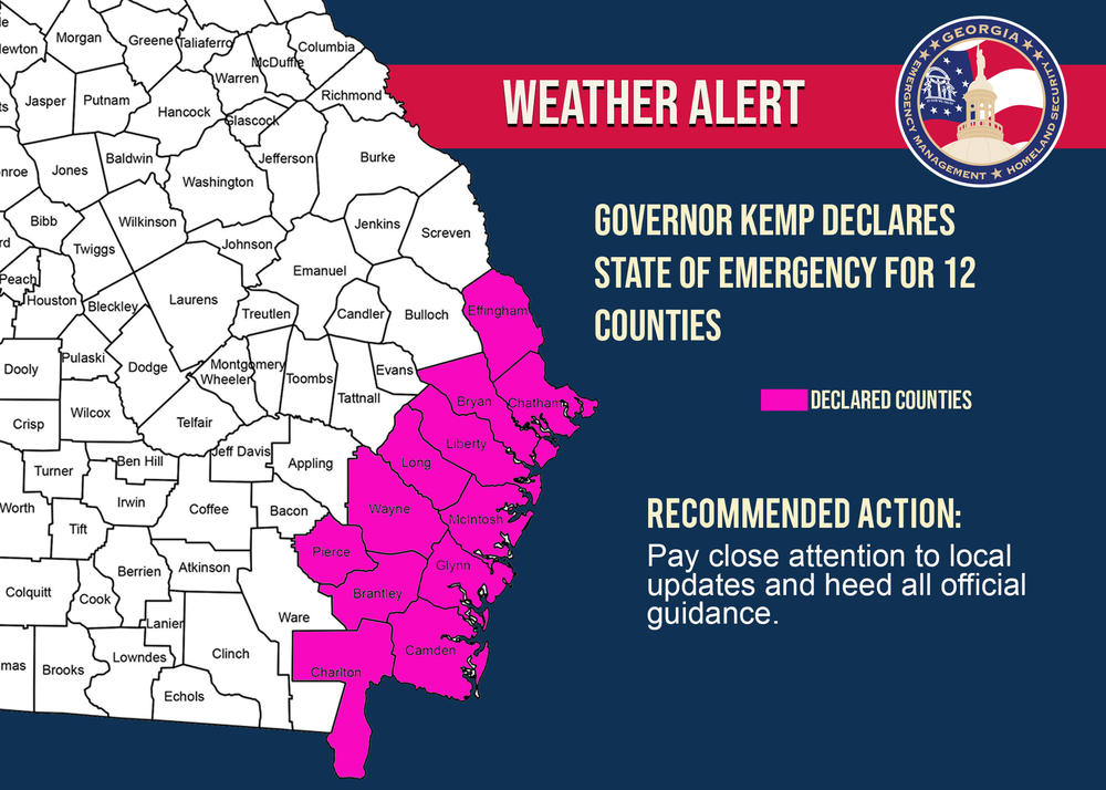
In the state of Georgia, based on information from GEMA, Gov. Kemp will issue issue an executive order for mandatory evacuations of the six Georgia counties East of I-95 starting at Noon today. Will also order “contraflow” on I-16 starting at 8 AM Tuesday.
The Storm Surge Watch has been extended northward along the Georgia coast to the Savannah River.
The Hurricane Watch has been extended northward to Altamaha Sound in Georgia.
NEW 3:45 PM EDT -- The Richmond County Schools System will be closed Tuesday, Sept 3 through Thursday, Sept. 5 in an effort to support evacuees from Savannah-Chatham County affected by Hurricane Dorian.
The Richmond County School System will received medical evacuees today with the general population scheduled to arrive tomorrow.
The Richmond County School System will received medical evacuees today with the general population scheduled to arrive tomorrow.
NEW 5:22 PM EDT -- Hurricane Watch Now for the Entire Georgia Coastline Storm Surge Warning has been extended northward to Altamaha Sound in Georgia.
VIRGINIA
Virginia Governor Ralph Northam has declared a state of emergency as forecasters. Although forecasters predict that Florida, Georgia, and North and South Carolinas will be hit hardest as the storm makes its way north, parts of Virginia may be affected as well.
“Potential impacts from Hurricane Dorian include coastal and inland flooding, storm surge, damaging winds and prolonged power outages,” the governor’s office wrote in a statement.
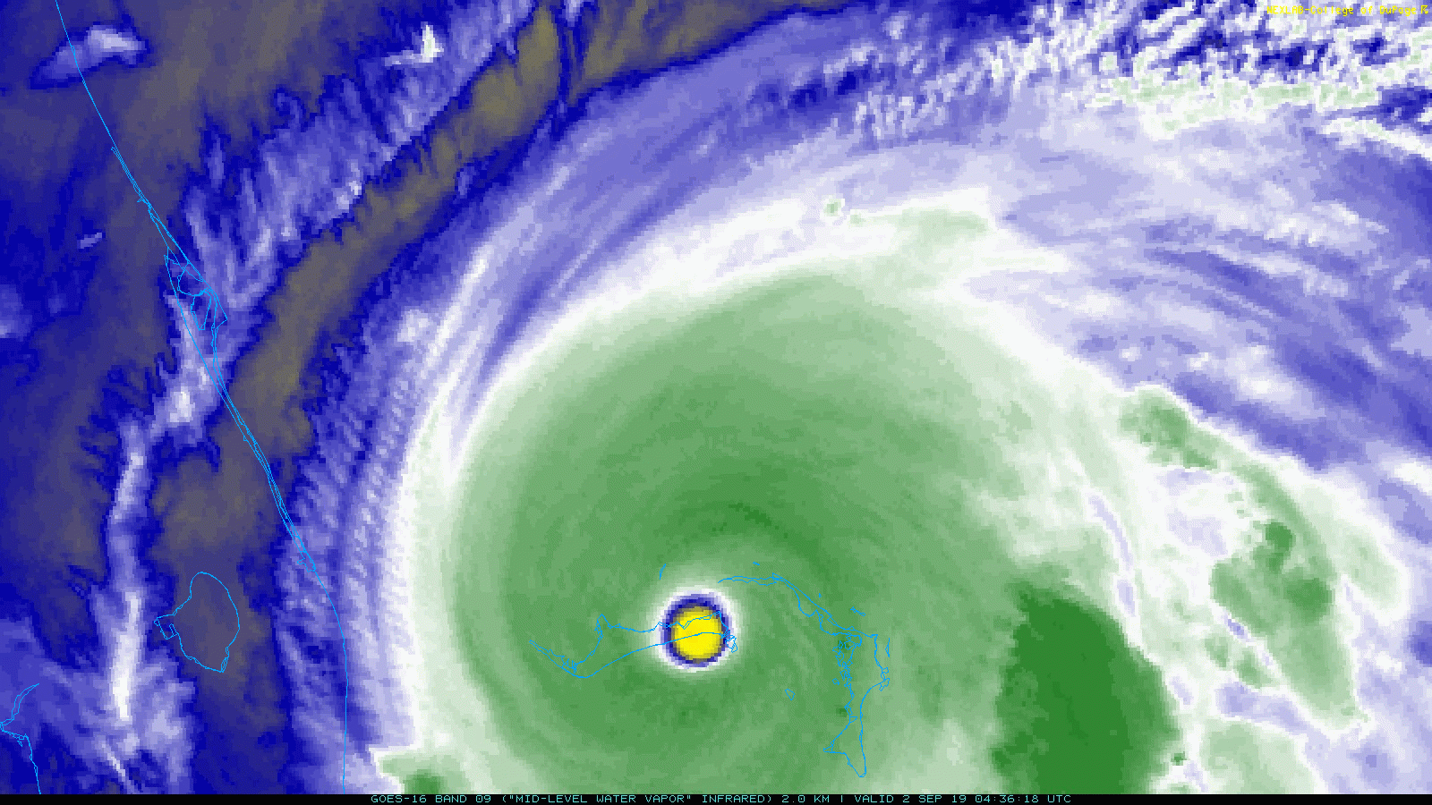
Here is another view
Here is the latest official coverage
“Potential impacts from Hurricane Dorian include coastal and inland flooding, storm surge, damaging winds and prolonged power outages,” the governor’s office wrote in a statement.
Here is another view
Here is the latest official coverage




No comments:
Post a Comment
Note: only a member of this blog may post a comment.