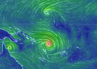
There is a possibility that the series of intense Pacific cyclones we are experiencing at the moment will give momentum to the El Nino.
I
am watching Tropical Cyclone Pam as I type this and I believe that
more intense the El Nino the more extreme the weather and forcing
will be. Expect the worst from this very bad news that we have been
dreading but expecting.
--- Kevin Hester
‘Twin’ Cyclones Could Jolt Weak El Nino
Weather
geeks have been fixated
this week on
an unusual meteorological phenomenon over the Pacific Ocean: Two
tropical cyclones are spinning directly across the equator from each
other.
13
March, 2015
But
these “twin” cyclones aren’t just a satellite spectacle, they
could give a jolt to the El Niño that was officially declared by
U.S. forecasters last week after months of sitting on the fence. This
El Niño is a weak one, expected to have little impact on weather in
the U.S. The two storms that could provide a boost, however, are
Cyclone Pam, churning over the South Pacific at about 14 degrees
south latitude, threatening the islands of Vanuatu and Fiji with
strong, damaging winds and storm surge, and Tropical Depression 3 (or
Bavi), spinning over the northern Pacific near 10 degrees north
latitude heading towards Guam.
Together,
the cyclones and El Niño illustrate the interplay between short-term
weather and longer-term climate cycles, in this case potentially
reinforcing each other. It is unclear, though, whether the cyclones
caused a westerly wind burst ramping up the El Niño, or if it was
the El Niño pattern that spawned the cyclones.
El
Niño is a climate condition marked by unusually warm ocean waters in
parts of the tropical Pacific, but it has impacts on weather all over
the globe. By influencing atmospheric circulation, a strong El Niño
can bring unsusually wet weather to the southern portions of the U.S.
in the winter months, as well as drought to places like Australia and
Brazil. It also tends to tamp down hurricane formation in the
Atlantic Ocean, while amping up storms in parts of the Pacific. The
weather connections are less strong in spring, but if this El Niño
strengthens enough over the spring and summer, it could have
ramifications next winter.
Where
the two cyclones come in is the winds associated with an El Niño.
Normally, the tropical Pacific features a pool of warm water in the
west and cooler temperatures to the east, where cold waters well up
from deep off the coast of South America. The prevailing easterly
trade winds keep this temperature pattern in place. When an El Niño
occurs, the winds slacken and can even reverse to blow from the west.
That sends the warm waters spilling eastward, the hallmark of an El
Niño. (When a La Niña occurs, the easterlies grow stronger and
intensify the east-west temperature contrast.)
Bavi,
because it is in the Northern Hemisphere, rotates counterclockwise,
while Pam, rotates clockwise in the Southern Hemisphere. In the
portions of the storms nearest the equator, the winds in both storms
are from the west.
“We
have an impressive westerly wind burst on the equator right now,”
Michelle L’Heureux, an El Niño forecaster with the National
Oceanic and Atmospheric Administration, said.
“The
winds are certainly tied in with these twin cyclones straddling the
equator.”
Those
westerly winds could help push the warm waters on the western side of
the basin further east and strengthen what is right now only a very
weak El Niño.
The
El Niño forecasters expected the increase in westerly winds
according to their models and it is “something we like to see when
we're saying an El Niño is in place and forecasted to continue,”
L’Heureux said.
What’s
hard to determine is whether the cyclones created the wind burst or
the other way around, as westerlies are also conducive to cyclone
formation in that area. Both could also be linked to a climate
pattern called the Madden-Julian Oscillation (MJO), which features
alternating areas of enhanced and suppressed rainfall that move from
west to east across the globe. When enhanced rainfall is over the
western Pacific, it tends to whip up the westerlies that can feed
cyclones and the El Niño. And this round of MJO could be
record-breaking.
But
it’s hard to predict how big an impact this push of winds will have
on the El Niño.
“How
much this westerly wind burst will energize El Niño is the big
question mark,” L’Heureux said.
Forecasters
are wary of a repeat of last year when a relatively strong MJO and a
very strong surge of warm waters, called a Kelvin wave, had some
predicting a repeat of the monster El Niño of 1997-1998. Then the
event fizzled.
“It's
still March, [and] as we know from last year, Kelvin waves are not a
slam-dunk predictor of [El Niño],” L’Heureux noted.


No comments:
Post a Comment
Note: only a member of this blog may post a comment.