End
of the hot weather. Now pull the other leg you fuckers.
A big hot patch of water in the Tasman and the thermometer in our kichen (23C) tells another story. This is the second such article today. Is it not enough that they lie through their teeth about climate change.
A big hot patch of water in the Tasman and the thermometer in our kichen (23C) tells another story. This is the second such article today. Is it not enough that they lie through their teeth about climate change.
Now
they even lie about the weather.
Heavy
rain and thunderstorms to end run of hot weather
Summer
has been put on hold in some parts of the country, with many western
areas soaked by an unseasonable downpour and more rain likely on the
way.
18
January, 2018
Parts
of Nelson received up to 150 millimetres of rain in 12 hours
yesterday and it was likely parts of Northland will get a similar
amount today.
Heavy
rain is also expected for Auckland and Taranaki.
MetService
has issued heavy rain warnings for the Coromandel Peninsula, Waikato
and Waitomo in the North Island.
Nelson
has been inundated with rain overnight - with more than 300
millimetres of rain falling in one part of the region.
MetService
forecaster Sarah Haddon said the largest downpour so far had been
near Takaka.
She
said rain should start to ease in the Nelson region, but showers were
likely to continue across most parts of the country
The
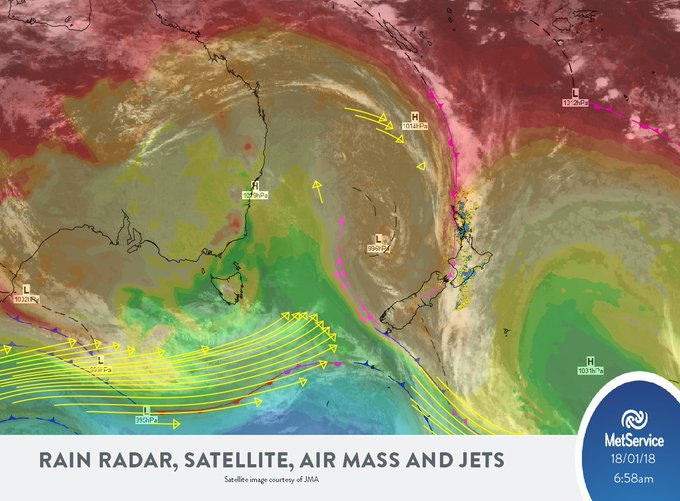
bad weather is being caused by a sub-tropical front lingering over
the west coast of the country, and it was expected to last until
Saturday morning.
MetService
say humid northerlies persist over central and northern New Zealand
over the weekend, while a low approaches from the north Tasman Sea.
They
said the low is likely to bring further rain to the North Island and
upper South Island during Sunday and Monday, with some heavy falls
possible.
However
some parts of New Zealand will continue to see hot and dry weather
today.
Main
centre forecasts today
Auckland
A
rainy day with some heavy falls, brisk northeasterlies and a high of
23°C.
Hamilton
Also
a rainy day with possible heavy falls, gusty winds and a high of
22°C.
Tauranga
Cloudy
with occasional rain, becoming persistent in the afternoon. Some
brisk winds that will ease in the evening. Will reach a high of 23°C.
Wellington
Rain
at times, possible heavy falls with some brisk northerlies. Will
reach a high of 22°C.
Christchurch
Mainly
fine. A chance of showers from the afternoon. Will reach a high of
29°C.
Dunedin
Showers
from around midday, a chance they could be heavy with thunderstorms
in the afternoon and evening. Will reach a high of 23°C.
Invercargill
Fog
lifting this morning as showers develop. Showers clearing at night.
Southerlies dying out in the evening. Will reach a high of 23°C.
-
MetService
This is a more accurate view.
This interview with climate scientist Jim Salinger and zoologist Alison Balance provides a good description of the "heatwave" in the Tasman Sea while ignoring the bigger picture.
This interview with climate scientist Jim Salinger and zoologist Alison Balance provides a good description of the "heatwave" in the Tasman Sea while ignoring the bigger picture.
If
you've jumped in the sea this summer and found it to be a
surprisingly warm temperature that's because the Tasman Sea is
currently going through a "marine heatwave".
Since
November the water has been more than 2 degrees above average...in
fact it's been the warmest ever in records going back to 1900, for
December at least.
And
while that feels great for beachgoers, it's not great for ocean
species - extreme systems like this can have a profound affect on
marine ecosystems.
Simon
Morton speaks to climate scientist Dr Jim Salinger and Our Changing
World's Alison Ballance


No comments:
Post a Comment
Note: only a member of this blog may post a comment.