Just
as the Atlantic is being hit by storm after storm the Pacific region
and New Zealand is being battered.
Cyclone
Hola: Could reach Category 5, winds of 300km/h, NZ in sights
Tropical Cyclone Hola has rapidly intensified to a Category 4 and could reach Category 5 tomorrow, with winds up to 300km/h as it batters Vanuatu, then heads for New Zealand.

8
March, 2018
The
Fiji MetService upgraded the cyclone to Category 4 this morning,
warning of sustained winds of 170km/h. Wind speed is expected to
reach 200km/h today.
Vanuatu's
Meteorology and Geo-hazards Department said this morning
hurricane-force winds gusting to 185km/h were expected to hit
Malekula and the Shepherds group tonight and in the next 12 to 24
hours. Damaging gale-force winds continue to affect the island of
Ambrym in the Malampa Province.
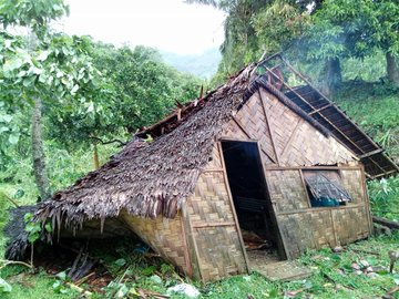
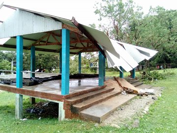
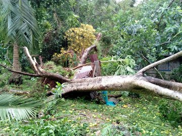
Minor to moderate damage to trees and structures in Central Pentecost.
Images courtesy of Andrew Gray.
Three
forecasting models for Tropical Cyclone Hola predict the storm is
likely to hit New Zealand's North Island early next week

Two
models, from the UK Met Office, show Hola could hit the Bay of Plenty
on Monday. It would be the third cyclone this season to affect New
Zealand.
The
third model, from the European Centre for Medium-Range Weather
Forecasts, predicts it could make landfall about 6pm on Monday.
MetService
New Zealand lead meteorologist Mark Todd said computer models were
still struggling to give an accurate track but it was looking
increasingly likely the storm would affect New Zealand.

Hola
has been moving slowly over Vanuatu during the past 24 hours, and
reports say gale-force winds are collapsing some houses.
The
roof of a classroom was blown off and some houses collapsed on Ambrym
as the cyclone arrived, Radio New Zealand reported.
Todd
said it was west of Vanuatu this morning, and moving slowly further
west.
"We
expect over the next day it should start to recurve to the
south/southeast, in the general direction of New Zealand.
"If
we are lucky it will pass just to the north of us. If we are unlucky,
it could be a direct hit into the North Island.
"By
then it will become an extra-tropical system, as always happens, but
if it does make a direct hit there will be heavy rain and high
winds."
Vanuatu Red Cross is using social media to warn people to be prepared for #cyclone #Hola which has just hit the northern islands. Volunteers are on standby. facebook.com/VanuatuRedCros… #CommisAid
A
"cut-off low" west of New Zealand has been wreaking havoc
as it moves slowly over the North Island.
"We
have a deep low in the upper atmosphere and a deep low at the surface
generating all the rain and wind," Todd said.
And here's a great explainer on the structure of a tropical cyclone #TCHola ^TA
Heavy
rain and thunderstorms rocked much of the island last night when up
to 200mm falling in places.
Wairarapa,
Tararua and Hawke's Bay south of Hastings have a severe rain warning
in place through to 9pm.
Heavy
rain warnings remain in place for Taranaki through to 1pm.
"The
heaviest falls were in the central areas, from Hawke's Bay and the
Wairarapa through the central high country to Taranaki," Todd
said.
More
than 200mm was recorded on Mt Taranaki, and 129mm in nearby Stratford
during the past 24 hours.
On
the East Coast 90mm fell at Castlepoint in the Wairarapa and 83mm in
Taumarunui.
The
lower North Island including Wellington has been experiencing
gale-force winds.
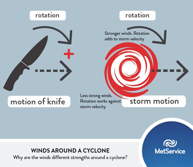
Where are the strongest winds around a tropical cyclone? This analogy of a knife may help! Strongest winds where rotation adds to the system velocity. If When #CycloneHola is travelling SE, strongest winds will be to NE. ^TA
"These
are not expected to ease off," Todd said.
"There
will be a gradual trend off, as the weather system moves very slowly.
"There
is a risk of more widespread thunderstorms today, mainly in the
central and upper North Island, even some hail."
Temperatures
today would be much the same as yesterday, and the South Island is
"the place to be", Todd said.
"There
is a somewhat cooler air mass over the South Island, but it is going
to be sunny, with very little rain."

Minor to moderate damage to trees and structures in Central Pentecost.
Images courtesy of Andrew Gray.
/arc-anglerfish-syd-prod-nzme.s3.amazonaws.com/public/K5JIKIMGCZEWLNNBLYTUJHR5IU.jpg)
/arc-anglerfish-syd-prod-nzme.s3.amazonaws.com/public/Z65WTVDKPJFFPH2KC45X56PEBU.jpg)
Vanuatu Red Cross is using social media to warn people to be prepared for #cyclone #Hola which has just hit the northern islands. Volunteers are on standby. facebook.com/VanuatuRedCros… #CommisAid
And here's a great explainer on the structure of a tropical cyclone #TCHola ^TA
Where are the strongest winds around a tropical cyclone? This analogy of a knife may help! Strongest winds where rotation adds to the system velocity. If When #CycloneHola is travelling SE, strongest winds will be to NE. ^TA
Cyclone Hola: What NZ needs to know
There's a "significant probability" the remnants of Tropical Cyclone Hola will sweep over New Zealand on Monday - the third major storm to hit the country this year.

RSMC
Nadi Tropical Cyclone Warning Centre
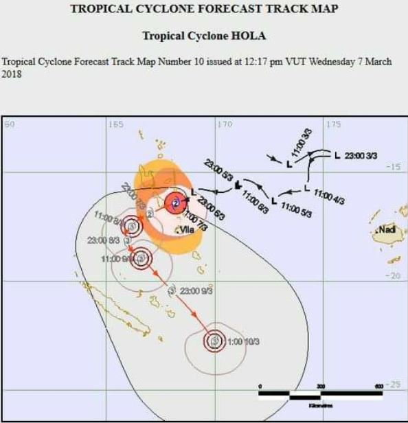
The
forecast track of Tropical Cyclone Hola issued by RSMC Nadi Tropical
Cyclone Warning Centre around 8.45am Thursday. Times are UTC which is
13 hours behind NZ daylight time.
8 March, 2018
So
what do we need to know?
Hola intensified
to category 4 strength early on Thursday, after crossing over
Vanuatu, and was moving west southwest.
It
was intensifying and, after changing direction, was expected to
pass between Vanuatu and New Caledonia on Friday. It was
possible it could grow to a category 5 cyclone, MetService said.
READ
MORE:
* Strengthened Tropical Cyclone Hola batters Vanuatu, likely to hit New Zealand
* People living near the Esk River in Hawke's Bay told 'be ready to evacuate'
* Photos: Ex-cyclone Gita hits NZ
Where
will it hit?
Latest
forecast tracks indicated Hola would start tracking to
the southeast on Friday. The final track would be highly dependent on
where and when it "recurved", but it was expected to pass
near or over the top of the North Island.
It
could catch Northland, Auckland, Bay of Plenty and Gisborne in
its wake.
How
powerful will it be?
That
is not known yet, as some forecasts say it will gain strength in the
coming days. But Metservice said it would bring a short spell of
wind, rain and larger swell, with possible severe weather in places.
On Thursday the storm had sustained winds of 165kmh and gusts of
230kmh.




No comments:
Post a Comment
Note: only a member of this blog may post a comment.