

Saskatoon
and Moose Jaw had their driest springs ever recorded
Saskatoon saw only nine percent of its typical precipitation over the last three months
CBC,
3 June, 2019
Most of the prairies have been waiting for spring showers that never materialized.
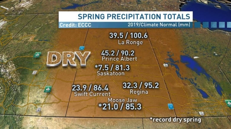
This spring was the driest on record in Saskatoon and Moose Jaw, and in the top ten driest springs on record in many other areas of southern and central Saskatchewan, according to Environment and Climate Change Canada.
In Saskatoon, after a record dry April, only 4.4 millimetres of precipitation fell in May. The area should normally see around 43 millimetres of precipitation in May.
Moose Jaw was similarly parched, with only 3.5 millimetres of precipitation in May when it should typically see 48 millimetres.
Severe drought in much of Sask.
This moisture deficit has been going on for quite some time. The last two years have been marked by dry summers and persistent drought conditions.
This spring Saskatoon saw only nine percent of its typical precipitation. Regina, although not record breaking, only saw 34 percent of its normal precipitation in March, April and May.
With those low numbers, most regions between Saskatoon and the United States border are dealing with moderate to severe drought conditions.
Jet stream to blame
Over the last little while our jet stream — the fast moving band of air in the upper atmosphere that separates cold air from warm air and guides our weather systems — has been sitting over the United States keeping heavy, flooding rain to the south.
Our polar jet has been pushing systems to the north of British Columbia, Alberta and Saskatchewan, leaving Western Canada in the dry and calm air in the middle.
This pattern has been acting as a block in our atmosphere, meaning day after day of similar conditions.

Abnormalities could become the norm
As our planet warms at different rates, the frequency of these long abnormal stretches of weather could increase.
Terri Lang, a meteorologist with Environment and Climate Change Canada, said our irregular jet stream is connected to how the planet is warming.
"With the Arctic warming faster than the rest of us, there isn't as much of a temperature difference. That means the jet stream is weaker."
A weak jet stream will undulate and meander more, leading to these longer stretches of abnormal weather.
When will this dry pattern break?
There is some good news.
The jet stream pattern that has been blocking weather systems from Saskatchewan has broken down, meaning we will see a return of moisture in the province.
With that return, however, we run the risk of severe thunderstorms developing. Although those storms mean more rain, they also bring the potential for lightning strikes on very dry vegetation.
Saskatoon's forecast is looking at quite the change. Thunderstorm activity will likely spark up this week, with showers and much cooler conditions on tap for the long range forecast.
No comments:
Post a Comment
Note: only a member of this blog may post a comment.