Unusual
winter warmth predicted to extend through spring for most of
Australia

The
Bureau of Meteorology's three-month
outlook released on
Thursday also shows the odds will favour milder overnight
temperatures will extend through much of September to November for
eastern half of the country. (See chart below.)
![]()


SMH,
17
August, 2017
Most
of Australia can expect a hotter-than-average spring driven in part
by unusually warm waters off the east coast, increasing the chances
of an early and active fire season in the south-east.
For
Sydney, the outlook is also for the abnormally warm winter to extend
through spring.
Felicity
Gamble, the bureau's acting head of climate prediction services, said
that with neutral influences in the Indian, Pacific and Southern
oceans, secondary factors such as the balmy waters off the east coast
were playing a key role.
Most
of Australia can expect a hotter-than-average spring driven in part
by unusually warm waters off the east coast, increasing the chances
of an early and active fire season in the south-east.
For
Sydney, the outlook is also for the abnormally warm winter to extend
through spring.
Forest
regions of NSW, including areas around Sydney, are rapidly drying
out, raising the risk of early and significant fire activity this
bushfire season.
The
Bureau of Meteorology's three-month outlook released on Thursday also
shows the odds will favour milder overnight temperatures will extend
through much of September to November for eastern half of the
country. (See chart below.)
Felicity
Gamble, the bureau's acting head of climate prediction services, said
that with neutral influences in the Indian, Pacific and Southern
oceans, secondary factors such as the balmy waters off the east coast
were playing a key role.
"We're
seeing those above-average temperatures [of winter] continuing,"
Ms Gamble said, adding a clear climate change signal was evident.
"It's the background trend in warming temperatures that we've
seen over the past couple of decades."
For
Sydney, day-time temperatures so far this winter have been averaging
19.3 degrees, ranking it third behind 2013 and 2005, Blair Trewin,
the bureau's senior climatologist, said. It's also likely to be among
the top four warmest Augusts for NSW.
The
city will have a couple of relatively chilly days on Friday and
Saturday with tops of 16 degrees forecast. The rest of the month is
likely to have average maximums of about 20 degrees, Joel Pippard, a
Weatherzone meteorologist said.
July
was easily
Australia's hottest on record for daytime temperatures and
June was the seventh-warmest, the bureau said earlier this month
Globally, last month tied with July a year ago as the warmest on record, NASA said earlier this week.
Rain outlook
A warm spring may add to the drying out of much of Australia after a drier than usual winter.
The bureau's outlook points to mixed odds for rain for the eastern part of the country, while the south-west may be in for a dry spring. (See chart below.)
Cooler-than-normal waters off the west coast means "there's less moisture to be drawn" as rain-bearing fronts move in, Ms Gamble said.
With little additional rain, July and August are shaping up to be Sydney's driest for those two months since 1995, Dr Trewin said.
A Fairfax Media has reported, bushfire researchers have already identified low moisture levels in both dead and live fuel across regions near Sydney and the far south coast of NSW.
The Sydney region can expect another mostly dry week, with the chance of some rain on Monday, Mr Pippard said.
After past two months of particularly dry weather, fire crews in NSW may be in for an active spring.
"It's definitely worth considering an early start to the bushfire season for most of NSW and southern Queensland," Mr Pippard said.
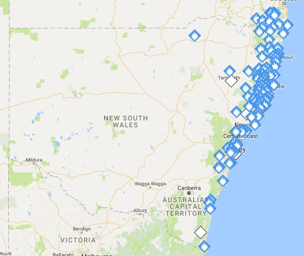
The NSW Rural Fire Service said on Wednesday they were battling 70 fires across the state, with many still active on Thursday morning:
Both states have had a few particularly warm days this week. Sydney posted its warmest August morning for 6am readings on Wednesday, with the mercury sitting on 22.1 degrees.
Odds continue to favour an early and active fire season for NSW. Photo: Wolter Peeters
Elsewhere in NSW, Port Macquarie and Coffs Harbour both posted their hottest days on Wednesday for this early in the warming season. On Tuesday, Wilcannia and Cobar in the state's west had their hottest August days on record.
The bureau's outlook release on Thursday marks the first of a regular fortnightly rather than monthly update. The more frequently releases are intended to give farmers and other users of the climate maps earlier access to any change.
The move follows an instance in October 2015 when the bureau noted a sudden shift towards drier conditions with an emerging El Nino. That prompted a mid-monthly report that will now become standard by the agency.


No comments:
Post a Comment
Note: only a member of this blog may post a comment.