Hurricane Harvey Strengthens to 110 mph Winds; Catastrophic Flooding Likely in Texas

Wunderground,
25
August, 2017
Dr.
Jeff Masters · August
25, 2017, 2:34 PM
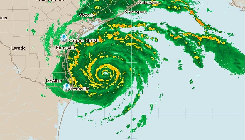
| Above: Radar image of Hurricane Harvey at 9:05 am CDT Friday, August 25, 2017. |
Hurricane Harvey is poised to deliver a catastrophic flooding blow to Texas after putting on an impressive round of rapid deepening Friday morning that brought the storm to the verge of Category 3 strength. Harvey passed over a warm ocean eddy with high heat content for over 6 hours Friday morning, and the extra energy the eddy provided allowed Harvey’s central pressure to fall a spectacular 15 mb in just two hours, from 967 mb at 4 am CDT to 952 mb at 6 am CDT. It takes several hours for a hurricane’s winds to respond to a rapid pressure fall, so we can expect that Harvey will be a Category 3 hurricane with 120 mph winds by Friday evening. An Air Force hurricane hunter aircraft in the storm this morning was continuing to see falling pressures, with the 8 am CDT eye penetration recording a 949 mb pressure. The aircraft also observed evidence that an eyewall replacement cycle was beginning. In this situation, the inner eyewall would collapse and be replaced by a new eyewall with a larger diameter, which would likely slow down or end Harvey’s intensification phase.
Harvey is a very dangerous hurricane with extreme winds, storm surge, and rainfall. If you live in Texas, please heed the advice of local emergency management officials, and get out immediately if you live in an evacuation zone. Heavy rain squalls and strong wind gusts are already affecting the Texas coast, and tropical storm-force winds will begin affecting portions of the coast late Friday morning or early Friday afternoon, making evacuation difficult.
 |
Figure 1. Hurricane Harvey as seen by the GOES-16 satellite at 8:30 am CDT Friday, August 25, 2017. Image credit:NOAA/CIRA/RAMMB. NOAA’s GOES-16 satellite has not been declared operational and its data are preliminary and undergoing testing.
|
Favorable conditions for intensification continue
Conditions in the Gulf of Mexico on Friday morning continued to be very favorable for intensification. Satellite images and radar showed that Harvey had expanded in size, and had a very impressive area of heavy thunderstorms with well-organized spiral bands that were dumping torrential rains. Harvey had an intense ring of very heavy thunderstorms surrounding a 13-mile diameter eye, and cirrus clouds streaming away from the center showed the presence of excellent upper-level outflow to the north and east, which was ventilating the storm and allowing intensification to occur. Wind shear was light to moderate, 5 – 15 knots, and the atmosphere had a high mid-level relative humidity of 70%. Sea surface temperatures (SSTs) were a very warm 30°C (86°F). Warm waters extended deep into the ocean, providing a large reservoir of heat for the storm to draw upon.
Intensity forecast for Harvey
The current favorable conditions for development will remain in place through Friday night, according to the 12Z Friday run of the SHIPS model. Wind shear will remain light to moderate, and the atmosphere will be moist. SSTs will remain near 29.5°C (85°F). However, Harvey has now the warm ocean eddy it traversed early on Friday morning, and the total ocean heat content has fallen from an estimated 83 kilojoules per square centimeter at 1 am EDT Friday, to 50 kilojoules per square centimeter at 7 am CDT. This is still warm enough to fuel intensification, but not the rapid deepening observed early this morning. Total ocean heat content will continue to fall as Harvey approaches the coast, reducing the odds of rapid intensification. Harvey has only one upper-level outflow channel, to the north, and typically two outflow channels are needed to support development into a strong Category 4 storm. Radar loops and eye reports from the Hurricane Hunters have observed that the eyewall of Harvey has had gaps in it this morning, which was likely limiting intensification.
The 0Z and 6Z Friday runs of our top intensity models—the HWRF, LGEM, COAMPS-TC, HMON, and DSHIPS—mostly predicted that Harvey would top out as a Category 3 storm with maximum winds of 120 – 125 mph before landfall. The HMON model was the most aggressive, predicting Harvey would max out as a Category 4 storm with 145 mph winds. Harvey may undergo an eyewall replacement cycle before landfall, which would likely weaken the top winds by 5 – 15 mph, but spread hurricane-force winds out over a larger area, increasing the storm surge. The 8 am CDT Friday eye report from the Hurricane Hunters documented concentric eyewalls with diameters of 13 and 31 miles, which is a classic first indication that an eyewall replacement cycle (ERC) is underway. The top winds observed by the aircraft were stronger in the outer eyewall than the inner eyewall, more evidence that the ERC is in full swing. We can expect that the inner eyewall might collapse later today, and the new eyewall will be the larger, 31-mile diameter one. In summary, we think the most likely peak intensity for Harvey is a Category 3 or 4 storm with 120 – 130 mph winds; a slightly lower landfall intensity of 110 – 115 mph can be expected if Harvey indeed undergoes a full eyewall replacement cycle. Either way, Harvey may bring the strongest hurricane-landfall winds to the U.S. coast in nearly 12 years, since Wilma (2005).
 |
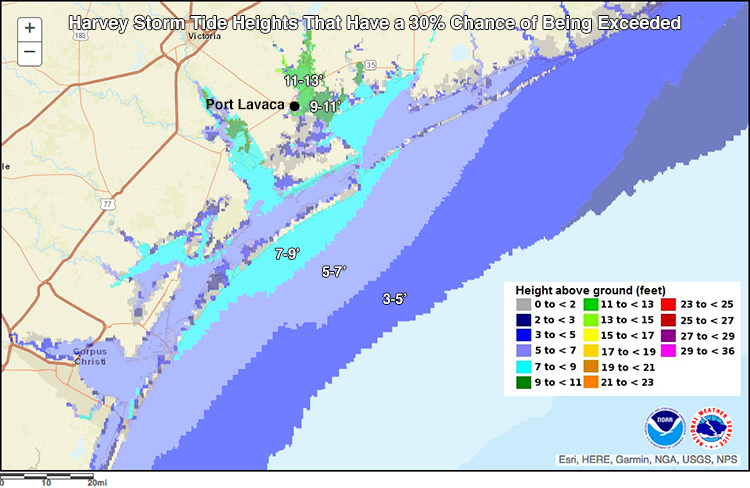
Figure 2. The NHC Potential Storm Surge Flooding Exceedance Map for Texas shows the maximum inundation heights above ground that have a 30% chance of occurring, during the period Friday - Monday. The peak surge is expected to occur about 50 miles northeast of Corpus Christi. The town of Port Lavaca has a 30% chance of seeing storm surge flooding of 11 -13’. Official storm surge forecasts may vary from these 30% probabilities; please consult local authorities and statements. Data is taken from the 4 am CDT Friday NHC advisory. Image credit:NHC.
|
Impacts
Wind: The 10 am CDT Friday Wind Speed Probability Forecast from NHC called for the greatest chances of hurricane-force winds in Rockport: an 90% chance. Corpus Christi had a 60% chance, Port O’Connor a 55% chance, and Matagorda a 23% chance. Galveston and Brownsville had much lower odds: 5% and 3%, respectively.
Rain: All of our top models are predicting that Harvey will dump catastrophic amounts of rain in coastal Texas. Some areas will likely receive 2 – 3 feet of rain over a 7-day period.
Tornadoes: The NOAA/NWS Storm Prediction Center has highlighted the tornado threat and placed parts of the central and upper Texas coastal plain, including the Houston area, under a slight risk of severe weather for both Friday and Saturday.
Storm Surge: Harvey’s dangerous peak storm surge of 6 – 12 feet will be capable of causing major damage along the central Texas coast. Storm surges as high as two feet were already being observed along the coast at 9 am CDT Friday. This region has a low tidal range, generally less than one foot between high and low tide, so the timing of Harvey’s landfall with respect to high tide will not make as much of a difference as we are usually concerned about with a hurricane landfall, though. NOAA has a nice “quicklook” page for Harvey that shows graphs of the water levels at gauging stations in the path of Harvey. In addition, our Wundermap with the “Storm Surge” layer turned on will give you a map with the surge values plotted. Here were the observed storm surges along the coast of central Texas, arranged from north to south, as of 9 am CDT Friday:
Galveston, 1.7’
Freeport, 1.6’
Port O’Connor, 1.6’
Port Lavaca, 1.5’
Seadrift, 0.6’
Copana Bay, .0.6’
Rockport, 0.8’
Port Aransas, 1.5’
Corpus Christi, 2.1’
Harvey’s combination of strength and rainfall duration has few if any parallels
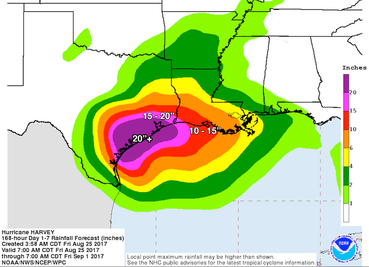
The historical record of U.S. hurricanes gives us few, if any, analogs for a major hurricane landfall that transitions into a multi-day rainfall event as prolonged, extensive, and intense as the scenario painted by multiple forecast models for Harvey. All four of the high-probability 0Z Friday European model ensemble members, and all but one of the 20 GFS members, maintain Harvey at Cat 1 strength (or better) for the next five days. The official NHC forecast on Friday morning called for Harvey to maintain tropical storm strength throughWednesday. Even after Harvey weakens below hurricane strength, gale-force winds will continue to pump vast amounts of moisture onshore, fueling several days of heavy rain. The latest 5-day precipitation outlook from the NOAA/NWS Weather Prediction Center (see Figure 3) projects that an area larger than the state of Massachusetts, including Houston and Galveston, can expect more than 20” of rain between now and Wednesday. Amounts of more than 10” cover an even larger area, extending into parts of the Austin-San Antonio urban corridor and including Corpus Christi and Beaumont-Port Arthur, TX, and Lake Charles, LA. Very serious flooding over the next several days can be expected well inland from the areas immediately at risk from Harvey’s initial landfall and storm surge. For example, Austin/San Antonio NWS office notes the potential for life-threatening flash flooding, especially from San Antonio south and east.
Tropical cyclones that produce inland flooding this widespread and intense tend to be weak, slow-moving tropical storms or tropical depressions, such as Tropical Storm Allison (2001), or even unclassified systems such as the “no-name” flood of 2016 that devastated southeast Louisiana. Both events produced more than $10 billion in damage (2016 dollars), and comparable amounts of flooding and damage are certainly possible with Harvey. Moreover, because Harvey is arriving as a much stronger hurricane, prolonged gale-force winds, perhaps extending well inland, have the potential to knock down many trees and power lines in areas where the soil is saturated, so power outages may be unusually extensive. Residents across south central and southeast Texas and southwest Louisiana should be prepared for the possibility of going multiple days without power.
 |
| Figure 3. Rainfall forecast for the period from Friday morning, August 25, through Wednesday morning, August 30. Localized amounts may be even higher, and some shifts to the contours of this area can be expected depending on Harvey’s eventual track. According to NOAA's David Roth, this is the most rainfall ever predicted by NOAA's Weather Predition Center (WPC), going back several decades. Image credit: NOAA/NWS WPC and NHC. |
Dangerous compound storm surge and freshwater flooding for Galveston/Houston next week
Official NHC storm surge guidance, which extends out to 72 hours (currently through Monday morning, August 28), is not intended to depict the longer-term threat—perhaps extending well beyond Monday—posed just inland by huge amounts of freshwater blocked by the surge from flowing to the sea. Current storm surge warnings include Brazoria and Galveston, with a 2 - 4 foot surge expected from Harvey’s initial approach; however, more widespread flooding may occur in the Houston/Galveston area early next week. Storm surge expert Dr. Hal Needham, who is riding out the hurricane on Galveston Island, highlights the potential for catastrophic flooding in the Galveston/Houston area if Harvey moves back out over the ocean, intensifies, then moves toward northeast, just offshore of Galveston, as the European model is predicting. In a Friday morning blog post, Dr. Needham points out that Harvey is likely to produce a storm surge for Galveston and Bolivar Islands that is less severe than during Hurricane Ike (2008)—which produced a surge of up to 19 - 22 feet—but far more prolonged. The multi-day onshore flow and storm surge coupled with extreme inland rainfall would push enormous amounts of water from several directions into Galveston Bay and the Houston Ship Channel. The result could be widespread, possibly unprecedented flooding early next week across southeastern parts of the Houston metropolitan area along and near the bay and the ship channel.
“From personal correspondence with people in the western communities of Galveston Bay, most people are staying put and getting supplies ready, but not anticipating flood levels could come anywhere near Ike. However, compound flooding has the potential to flood locations that did not flood during Ike and inflict a widespread and long-term catastrophe that could last into the better part of next week,”says Needham. Similar levels of compound flooding just inland could affect other parts of coastal Texas and perhaps southeast Louisiana, he adds. A major 2016 investigative report from Pro Publica and the Texas Tribute, “Hell and High Water,” examines the huge economic and societal risks posed by hurricane-related flooding in western Galveston Bay and the Houston Ship Channel, which is one of the busiest shipping lanes in the world.
 |
| Figure 4. This graphic from Hal Needham illustrates the areas where freshwater outflow from extreme inland flooding could be impeded by storm surge in Galveston Bay early next week, if Harvey takes the type of track indicated by the European model, moving slowly northeast along the Texas coast southwest of Galveston. This schematic is not an official or literal depiction of areas expected to flood; for such guidance, please refer to statements from NHC, theHouston/Galveston NWS office, and local authorities. Image credit: Courtesy Hal Needham. |
Portlight disaster relief charity responding to Hurricane Harvey
The Portlight.org disaster relief charity, founded and staffed by members of the wunderground community, is responding to Hurricane Harvey. They need your help!! The flooding caused by Harvey will leave many people stranded, and experience shows that a disproportionate number of them will be people with disabilities and older adults. Portlight is rallying stakeholders and working to help get people to safety, and will provide for any immediate needs they may have for durable medical equipment and other assistive technology. Portlight will be touring Red Cross and independent shelters to promote full accessibility to the facilities themselves, and to disaster survivor services. We hope you'll consider supporting Portlight's work with a donation.
Bob Henson contributed mightily to this post.


No comments:
Post a Comment
Note: only a member of this blog may post a comment.