Record-threatening, ‘crazy’ heat forecast for western U.S. early next week

14 June, 2017
Interior California and the desert Southwest are bracing for an intense and long heat wave, forecast to start this weekend and continue well into next week.
The worst of the heat is expected Monday or Tuesday, when many locations will witness temperatures 15 to 30 degrees above normal, challenging records.

Forecast temperature difference from normal Tuesday late afternoon from GFS model. (PivotalWeather.com)
The National Weather Service has hoisted an excessive heat warning for Phoenix on Sunday through Wednesday, and excessive heat watches in Las Vegas, San Jose and Sacramento for the weekend and early next week.
In Phoenix, high temperatures are forecast to reach 110 to 120 degrees during this extended stretch.
GFS
model 10-day temperature forecast for Phoenix. (WeatherBell.com)
Monday
and Tuesday could be historically hot days, near 120 degrees —
which would rank among the top five hottest temperatures ever
recorded in Phoenix.
Top
five hottest temperatures in Phoenix:
1.
122 on June 26, 1990
2.
121 on July 28, 1995
3.
120 on June 25, 1990
4.
119 on June 29, 2013
5.
118 on several days
“Whats
crazy about all of this is that the all-time high temperature at
Phoenix Sky Harbor is 122 degrees set back in 1990 and there’s a
chance we could be near this record and possibly even break it if
things continue to trend upward,” the National Weather Service
office serving Phoenix wrote in a discussion Wednesday.
The
heat wave’s peak is expected to occur about the same time a
punishing blast of heat scorched the city a year before. On June 19,
2016, Phoenix soared to 118 degrees, a daily record, and tied for the
fifth-hottest day in the city’s history.
Most
of Phoenix’s daily record highs in the June 16-20 period have
occurred in the previous two years and could be tied or broken yet
again:
Date
record high
June
16: 115 in 1974
June
17: 114 in 2015
June
18: 115 in 2015
June
19: 118 in 2016
June
20: 116 in 2016
The
heat will spread through the desert of southern Nevada and Southern
California and then surge northward through California’s interior,
into the Sacramento Valley.
The
National Weather Service office serving Las Vegas said “near
record-high temperatures will be possible” Saturday through Tuesday
— about 110 to 112 degrees.
Sacramento
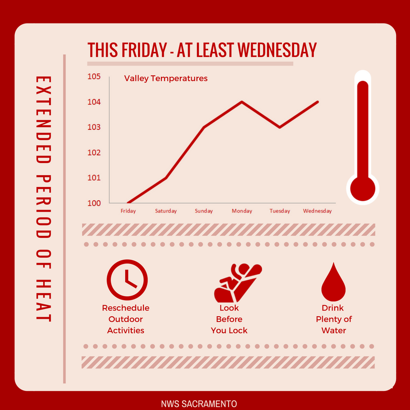
and its surrounding valley areas could endure triple-digit heat for
at least five days, according to the Weather Service.
Prepare now for an extended period of heat! Triple digit temperatures Friday - at least next Wednesday in the Valley! #cawx
“Stay
tuned and make necessary preparations,” the Weather Service
advised. “Is your AC functioning, do you have neighbors, family or
friends that may struggle with extended heat, can you modify outdoor
plans to avoid the hottest part of the day?”
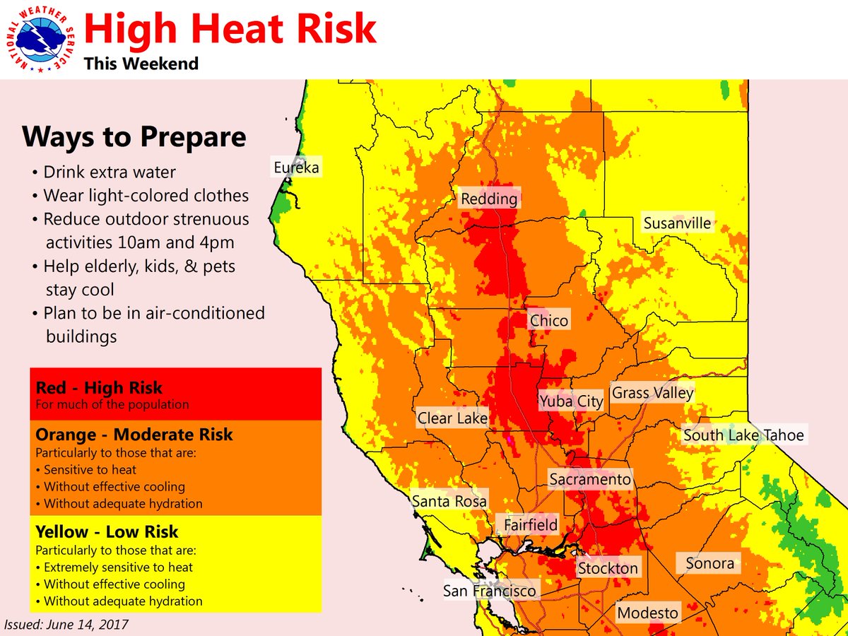
Outdoor plans for #FathersDay or graduation? Moderate-high risk of heat-related illnesses this weekend! Plan accordingly! #cawx #BeatTheHeat
The
culprit for the heat is an expanding and strengthening area of high
pressure aloft, sometimes called a heat dome, forecast this weekend
and next week.
GFS
forecast for high-altitude weather pattern Monday, showing a heat
dome centered over Arizona. (WeatherBell.com)
It
is not forecast to be quite as strong as the heat dome which sprawled
over this same region a year earlier but still has the potential to
produce historically hot temperature readings — especially over
Arizona, where it is forecast to reach maximum intensity.
If
you want to know what climate change feels like, you’re going to
find out this summer
On
Tuesday, some parts of the Midwest and Northeast saw temperatures 20
degrees above the historical average.
14
June, 2017
An
early summer heat wave delivered record
temperatures from
Nebraska to Maine this week. On Tuesday, some parts of the Midwest
and Northeast saw temperatures 20 degrees above the historical
average. And this is just the beginning of what is expected to be a
very hot summer.
A dip in the jet stream
in the Pacific Northwest drew cool Arctic air to the Sierra Nevadas,
while a high-pressure ridge over the Eastern United States drew warm
air from the Gulf of Mexico to the Midwest and Northeast. This all
happened against the backdrop of climate change, which pushed the
mercury from hot to scorching.
Globally, carbon
pollution is trapping heat, shifting the entire distribution of
temperatures. Cold days turn chilly. Cool days turn warm. And balmy
days turn sweltering. The collective output of tailpipes and
smokestacks is cranking up the global thermostat, producing milder
winters and more sizzling summers.
Temperatures
at the far end of the distribution, the ones that break records, are
almost invariably explained by carbon pollution. A recent
study found
that, globally, 85 percent of record-hot days are the product of
climate change.
 Climate change is shifting the distribution of temperatures. CREDIT: Environmental Protection Agency
The
shift in temperatures means less extreme cold and more extreme heat.
Correspondingly, record highs are now drastically outnumbering record
lows in the United States.
 Extreme
heat poses a serious threat to human health, particularly among the
elderly, who are less able to regulate their body temperature, and
among those who cannot afford air conditioning. Hot spells can prove
deadly. As temperatures rise, heat-related deaths are projected
to grow
exponentially.
Hot
weather also makes pollution worse. Heat and sunlight catalyze ozone,
contributing to hazy conditions, and worsening symptoms of asthma.
Air quality alerts were issued in Boston, New
York, Chicago,
and elsewhere amidst this week’s soaring temperatures. Officials
advised people with respiratory conditions to avoid going outdoors.
Temperatures
will cool later this week, but don’t expect it to last. The rest of
the summer is projected to
deliver unusually warm weather to the coasts and the South.
Jeremy
Deaton writes for Nexus
Media,
a syndicated newswire covering climate, energy, policy, art and
culture. You can follow him at@deaton_jeremy


No comments:
Post a Comment
Note: only a member of this blog may post a comment.