

Sydney
to hit 41 degrees as NSW bushfire danger returns
SMH.
23
January, 2020
NSW
residents are warned recent rainfall has not extinguished bushfires
burning across the state, and there is no room for complacency with
high temperatures and elevated fire danger about to return.
The
Rural Fire Service (RFS) has graded fire danger at "severe"
levels in a number of regions on Thursday, including the Shoalhaven,
Hunter, Illawarra, Sydney, North Western, and the southern and
central ranges.
Total
fire bans are in place for each of those areas on Thursday.
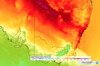
The
Bureau of Meteorology is forecasting temperatures in the high-30s to
low-40s for much of NSW on Thursday amid strong north-westerly winds.
Sydney
is predicted to hit a high of 41, with the chance of a thunderstorm
in the afternoon and evening as well as gusty winds. Even the Bondi
area, which is usually a few degrees colder due to coastal winds, is
tipped to reach 39 degrees.
Fire
weather is looking particularly dangerous in the Blue Mountains,
where 45-60km/h winds are forecast with gusts in elevated areas
potentially surpassing 90km/h.
A
weak southerly change won't hit Sydney until early on Friday morning,
dropping temperatures and bringing possible showers – but
temperatures on Friday and the weekend will remain above the average
(26) for January.
Nowra,
near the Currowan fire that has devastated much of the Shoalhaven
region, is also forecast to hit 40 on Thursday. Bowral, in the
Southern Highlands, with fires burning to its north and south, is
forecast to reach 35.
With
more than 60 fires still burning across NSW, RFS spokesman Ben
Shepherd said Thursday will be another "testing day" for
firefighters and communities close to the danger.
Recent
heavy rainfall across parts of the state "was most welcome but
it might give people a false sense of security", he said.
While
isolated areas received a large volume of rain during wild
thunderstorms earlier this week, many firegrounds – including in
the Southern Highlands and far south coast, only received 10-15mm, Mr
Shepherd said.
While
that "did take the sting out of current fire activity", it
was not enough to significantly impact the fire danger.
"By
no means are [the fires] all out, and it is likely over coming days
that we will see fires burn and move again," he said.
Isolated
heavy rain accompanying thunderstorms on Thursday evening may also
contribute to increasingly dangerous conditions across NSW
firegrounds, with loosened soil in fire-damaged areas potentially
causing landslips and falling trees.
Thunderstorms
moving across the state may also result in a repeat of the dust
storms seen in central-western NSW on Monday, bureau meteorologist
Abrar Shabren said.
There
is also potential for dry lightning strikes to result in new
ignitions, and hot weather in the days following could see them catch
on if there is not enough moisture around.
However,
Mr Shabren said there appears to be more showers on the horizon for
next week.
No comments:
Post a Comment
Note: only a member of this blog may post a comment.