

It’s
colder in parts of Australia than in Siberia, Greenland and northern
Canada
THE sunbaked
country is one of the coldest parts of the world right now, but
there’s a pretty good reason we haven’t seen snow.
7
July, 2017
WINTER’S
icy embrace of Australia continues unabated. In parts of NSW, the
mercury sank so low on Friday morning into subzero territory it would
have been balmier to witness the dawn in Iceland, Tierra del Fuego or
even Siberia.
Even
the most northerly inhabited place on earth, the hamlet of Alert in
Canada — a hop, skip and a sled from the North Pole — was warmer
than the Snowy Mountains last night.
In
the wee hours, temperatures plunged to -7.2C at Cooma Airport. Alert
could only managed a positively tropical 3C.

Cooma
currently colder than this place near the North Pole, surrounded by
icebergs. Picture: Google Maps.Source:Supplied
But
despite the big chill there’s not a lot of snow about, leading ski
bunnies to ask where in the world has all the white stuff been? The
good news is the powder is now pouncing.
A
stubborn high pressure system has helped keep the temperatures down.
Both Bathurst and Bombala dipped to -5.3C overnight, Thredbo went to
-5.7C, parts of Sydney’s west were at -1.5C at 7am while Victoria’s
Mt Hotham fell to -4.5C.
In
contrast, parts of the world famous for being freezing have got
nothing on Australia right now. Take a look at the places the
sunbaked country is currently out freezing.
— Cape
Dyer, Nunavut — the coldest spot in Canada yesterday: -6.7C
— Thule
Air Base, northern Greenland: 2C
— Reykjavik,
Iceland: 2C
— Tomsk,
Siberia, Russia: 8C.

Tomsk,
Siberia: Balmy compared to Australia.Source:News
Corp Australia
Now,
we know what you’re thinking. Isn’t it summer in the northern
hemisphere? So maybe it’s going to be a little bit warmer. But the
same story is played out in the southern hemisphere too, with our
wintry peers also unable to measure up.
— Ushuaia,
Tierra del Fuego, Argentina: 1C
— Queenstown,
New Zealand: -5C
— Sutherland,
coldest town in South Africa: 8C
Winter
records have been smashed across NSW and Victoria. The NSW Murray
River town of Deniliquin
recorded its coldest temperature in 110 years with
the mercury dipping to just -5.6C last week.
However,
according to Sky News Weather Meteorologist Tom Saunders there’s a
pretty good reason why we didn’t see a lot of snow last month —
and it’s all to do with a drier than normal June. No rain means no
snow.
“This
was the result of high pressure systems sitting further south than
usual,” Mr Saunders said.
“The
natural snow depth at Spencers Creek (NSW Snowy Mountains) was only
4cm at the end of the month — well below the average of about 70cm
at the beginning of July.”

Listen
up snow bunnies it’s time to get excited because there’s more
snow on the way. Picture: Sky NewsSource:Supplied
Mr
Saunders said snow has fallen this week with 10-20cm of powder
already recorded across most resorts. And get the skis out because
more is on the way.
“Another
pair of fronts should bring a further 10 to 15cm of snow from Friday
to Sunday,” he said.
“The
snow level will vary from 1000m to 1200m during this period, so snow
will only accumulate across the Alpine regions.
“It
has also snowed on the WA Stirling ranges twice in the past week.”
June
in Australia is traditionally unpredictable when it comes to the
amount of snow that falls. Heavier falls are usually guaranteed in
July and August.
Rhylla
Morgan, spokeswoman for Mt Buller ski resort, said while June had
been very dry, decent falls had finally arrived.

Snow
falls have hit Mt Buller, but there’s plenty more on the way this
weekend. Picture: Andre Railton /Mt BullerSource:Supplied
“We
had 12cm of snow add to our gauges here at Mt Buller yesterday and a
cold night which enabled more snow-making,” she said.
“Eight
lifts are in operation and we have an average cover of 20-39cm on
runs open with a terrain park also open for freestyle tricks and
jumps.”
Ms
Morgan said snow was forecast for tomorrow and the start of the week
with another 10-20cm expected.
“June
is often unpredictable (for snow falls) and sometimes we get lucky,”
she said.
“But
while June was dry we still had lots of blue sky which was
fortunate.”

Kids
are already getting into the spirit at Mt Buller. Picture: Andre
Railton/Mt BullerSource:Supplied
She
said the resort opened a week earlier than usual this season with
early falls in May, which allowed a decent cover while snow making
machines had been hard at work.
Ms
Morgan said the resort hit a high of just 3C today and temperatures
of between -2C and 4C were ideal for snow falls.
Perisher
spokesman Richard Phillips said the resort had been bitterly cold and
it hadn’t had a lot of fresh snow until recently.
The
resort was hit with 20cm of snow overnight and another decent fall
will hit tomorrow.
“It’s
-3C here at the moment,” he said.
“But
we had 20cm yesterday and with another 15cm predicted we are in for
an awesome weekend.”
Mr
Phillips said temperatures as low as -10C were recorded.
He
said cold temperatures in May provided a good start to the season but
the past month had been especially dry.
SKY
Four
days of hell: worst storm of year bears down on New Zealand
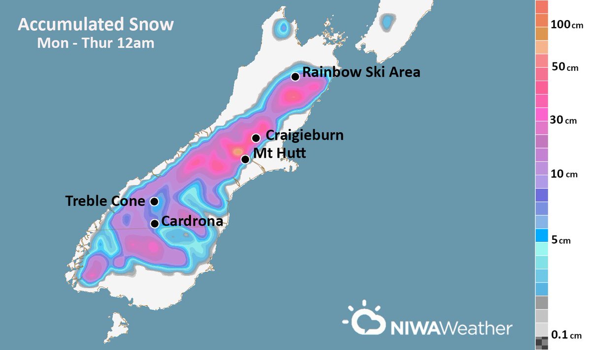
Potential snow accumulation through 12am Thursday.
For the mid & upper South Island, this represents only about 1/2 of the storm! 


10
July, 2017
The
country is preparing for its worst winter storm of the year with
rain, snow and gales set to batter much of New Zealand.
As
the first week of the school holidays gets under way MetService is
warning the vicious cold front is expected to hit tomorrow and last
for the next four days.
Snow
is expected to fall to very low levels in the south of the country
with potentially damaging gales, torrential rain and snow lashing the
country from Gisborne south.
The
Milford Rd is closing at 5pm with significant snow forecast to about
500m by tomorrow morning.
The
road will reopen as soon as crews have cleared the snowfall likely by
mid-morning tomorrow, a Transport Agency spokesman said.
Weatherwatch.co.nz
is forecasting the snow to fall down to sea level across Southland
and Otago tomorrow night with virtually nowhere in the South Island
escaping a wintry white-out.
Travel
across the country is expected to grind to a halt and farmers are
being told to move livestock ahead of the wintry blast.
Coastal
regions are being put on alert with possible flooding from strong
onshore winds, high waves and heavy rain colliding in the storm.
Sailings across Cook Strait could be in jeopardy with Niwa predicting
waves of up to 4m by Thursday.
Snow
is expected to fall for two straight days across the South Island -
in some areas down to 100m in southernmost regions and down to 200m
in Canterbury - followed by a bitterly cold southerly wind.
This
morning a swathe of road snowfall warnings for major alpine passes
and Dunedin's northern highway have been issued for coming days.
Projections
show some alpine areas will get up to 1m of snow over the coming 72
hours.
On
Wednesday the weather will continue to worsen as it tracks north with
severe gales, heavy rain and snow set to strike the centre of the
country.
Gales
are expected to batter Taranaki to Gisborne south and heavy rain is
expected to fall across the lower half of the North Island.
Snow
is expected to bring disruption to central and eastern areas with
forecasters predicting it will fall down to 600m across Wairarapa,
Hawke's Bay and east of Taupo.
Weatherwatch.co.nz
says the Wellington region could be hit by snow flurries down to 500m
by dawn on Wednesday.
The
weather is not expected to let up until Friday when it moves away
from the North Island
Ready for some ? The atmosphere is setting up to produce on both Islands this week, just in time for school holidays 
? The atmosphere is setting up to produce on both Islands this week, just in time for school holidays
MetService
forecaster Ciarin Doolin said with the wild weather is expected to
affect many parts of both islands and people could expect roads
across the country to become snowbound.
"This
front is expected to bring significant severe weather, affecting
many parts of New Zealand from Tuesday to Wednesday, including
heavy rain, snow and severe gales, and may cause disruption to
transport and stress to livestock. It is also worth noting that
for coastal areas exposed to a strong onshore flow, high waves and
heavy rain could lead to inundation," said Doolin.
"There
is still a degree of uncertainty in the computer models regarding
the mid-week severe weather event, so people are advised to keep
up to date with the latest Severe Weather Outlook. It is highly
likely that Severe Weather Watches or Warnings will be issued
nearer to the event."
Canterbury's
Civil Defence Emergency Management warned residents to prepare for
the approaching storm.
In
previous years, heavy snowfall and gales have led to road closures
and power outages affecting large parts of Canterbury, the group
said.
Motorists
considering driving over mountain passes in winter were advised to
take chains with them in case of snow and to check road conditions
and the weather forecast before setting out.
Meanwhile,
a perfect storm of rain and freezing temperatures in Otago and
Southland made for some of the most treacherous driving conditions
in decades, the Otago Daily Times reports.
A number of road ice warnings are in place in Otago/Southland. Go here for details .^SM http://ow.ly/FQCy30du0MI
Police
responded to more than 40 crashes across the South at the weekend
and warned drivers to stay off the roads on Saturday morning and
last night. Police put out warnings about Southland, Central Otago
and the Waitaki last night.
The
coldest temperature recorded by the MetService was -6.3C in
Alexandra on Saturday morning.
The
MetService is forecasting freezing temperatures to continue.
Frosts were expected this morning, and snow to 200m in Otago
tomorrow.
Lawrence
Volunteer Fire Brigade chief fire officer Rory Tisdall said
driving conditions were at the "most extreme" on
Saturday morning.
"I
have been in the Lawrence brigade for 24 years and the conditions
over this weekend were the most serious I've seen," Tisdall
said.
On
Saturday, temperatures of about -6C in places, combined with rain
about 6am, created the "perfect storm" for severe black
ice, he said.
The
most serious of the crashes he attended involved a van which
rolled after hitting ice on State Highway 8 near the Beaumont
Hotel and Holiday Park about 10.30am on Saturday.
The
van was being used by Green Island Football Club's premier team to
get to a game in Queenstown and teenager Matt Milton was airlifted
to hospital after suffering serious "crush injuries" to
his hand, shoulder and leg in the crash. The game with Queenstown
was called off.
Sergeant
Brent Kingsland, of Invercargill, said the same conditions had
caused "havoc" in Southland and it was "very lucky"
there were no serious injuries.
"There
were vehicle crashes all over the show," Kingsland said.
He
had worked in Invercargill for 16 years and the icy conditions
were the worst he had seen.
Police
in Southland attended about 28 crashes on Saturday.
In
Queenstown a man who was clocked at 179km/h in Gibbston on
Saturday was charged with driving at a dangerous speed.
Acting
Senior Sergeant Jared Kirk said the 40-year-old was caught
speeding in a 100km/h zone on SH6, near Victoria Flats Rd, about
3.25pm.
The
man had his licence suspended immediately, and will appear in the
Queenstown District Court on July 24.
"There
is still black ice and loose grit across many of our roads, so to
hear of driving behaviour like this is extremely disappointing.
"It's
clear the message is not getting through to some drivers."
Some
things to consider, from Canterbury Civil Defence:
Review your travel plans for the week; avoid driving if possible, otherwise keep driving to a minimum.
Review your travel plans for the week; avoid driving if possible, otherwise keep driving to a minimum.
Allow
extra travel time if you do need to drive.
Do
a thorough check of the vehicle and all equipment before driving.
Travel with extra clothing, food, water, and a phone charger.
No comments:
Post a Comment
Note: only a member of this blog may post a comment.