

Unprecedented Cyclone Chapala Bears Down on Yemen
31
October, 2015
Chapala,
now the unprecedented 23rd category 4 or category 5 tropical cyclone
to form during 2015, is bearing down on the nation of Yemen. A nation
that is likely to experience hurricane force winds and may receive as
much as 8 years worth of rainfall from Chapala’s intense spiral
bands over a 24-48 hour period.
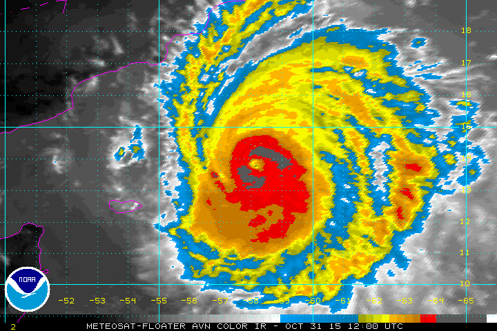
(Unprecedented
category 4 Chapala bears down on Yemen in the Halloween satellite
shot. Image source: NOAA.)
* *
* * *
After
a rapid bombification on Friday, Cyclone
Chapala became the most intense storm on record to form so far south
in the Indian Ocean.
Like Patricia, this storm gathered strength in waters that were much
hotter than normal (+1 to +2 C above average for the region). Like
Patricia, the storm rapidly intensified in a single 24 hour period —
gaining 90 mph of wind intensity in just one day. And
like the 5 billion dollar weather event that was Patricia,Chapala
threatens severe damage along its likely land-falling path. A
hothouse storm for a hothouse world that in 2015 has seen the
previous record for the rate of formation of the most intense
tropical cyclones shattered by five storms so far this year. The
previous record, set in 2004 was for 18 such storms over a one year
period. Now, the new record is 23 and counting.
Chapala
is expected to track west-by-northwest, weakening to a category 1 or
2 storm just before making landfall in Yemen on Monday. At that point
the storm is predicted to dump as much as 12 to 16 inches of rain
over parts of Yemen. If this happens as current weather models
predict, parts of Yemen which typically receive less than 2 inches of
rain per year may see as much as 8 years or more worth of rain fall
over the course of a day or two.
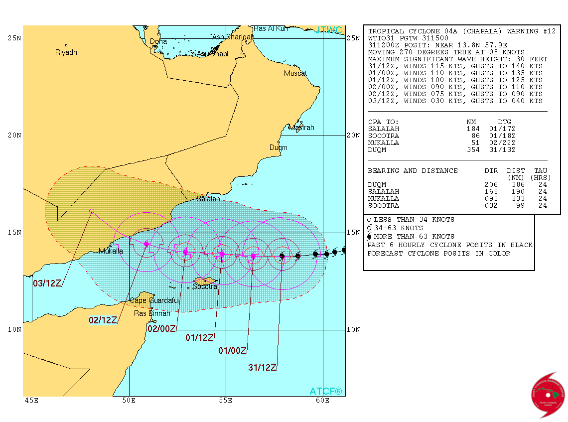
(Chapala’s
predicted path and intensity brings an unprecedented rain-maker to
Yemen. One that is capable of delivering as much as 8 years worth of
rainfall in 1-2 days. Image source:Joint
Typhoon Warning Center.)
Large,
powerful storms of this kind do not typically track into Yemen. And
the predicted and possible rainfall amounts would almost certainly
shatter all-time records for the arid state. A
potential event that Dr. Jeff Masters over at WeatherUnderground
yesterday called unprecedented.
Such heavy rains would hit a region that is not at all equipped for
dealing with so much water falling from the skies. Dry lands that
form a hard baked surface will tend to enhance pooling and run-off.
Regions that typically see extreme flooding from just 1 or 2 inches
of rainfall could see 5 to 10 times as much. Needless to say, this is
a developing and dangerous situation that bears careful monitoring.
Conditions
in Context — Powerful Hurricanes in a Hothouse World
2015
will close out as the hottest year in the 135 year climate record. It
will hit temperatures, globally, about 1.1 to 1.2 C hotter than 1880s
averages. This extreme temperature departure, is nearly 1/3 of the
difference between 1880 and the last ice age — but on the side of
hot. An extreme heating that is starting to force the glaciers of the
world to rapidly melt, the seas to rapidly rise, the oceans to
rapidly decline in health, and climates around the world to rapidly
destabilize.
The
oceans of the world draw in more than 90 percent of this excess heat
energy. The added energy at the ocean surface, in its turn, provides
more fuel for the most intense category 4 and category 5 tropical
cyclones. These storms draw their energy directly from heat and
moisture at the ocean surface. So as we, through our burning of
fossil fuels and emitting of greenhouse gasses which in turn warms
the climate, are unwittingly both increasing the frequency of strong
storms as well as adding to their maximum potential energy.
During
recent years, we have seen greater and greater numbers of the most
intense versions of these storms globally. During 2004 a new record
number for category 4 and 5 cyclones was breached, only to be
supplanted this year with the formation, so far, of 23 of these
monster cyclones. In addition, the number of records for most intense
storms for regions seems to be falling at an increasing rate. In
2013, cyclone Haiyan, roared into the record books as one of the most
intense storms the world had ever seen.
And this year we have two all-time basin records — Patricia and
Chapala.
The
human hothouse, thus appears to be providing more storms of high
intensity. And with more warming in store — with nations,
corporations, and politicians continuing to fight to delay climate
action, ever more dangerous storms are coming.
Links:
Hat
Tip to Colorado Bob
No comments:
Post a Comment
Note: only a member of this blog may post a comment.