Record Global Heat — Huge Springtime Arctic Warm-up to Crush Sea Ice, Drive Extreme Jet Stream Dip into Europe
22
April, 2016
We
know now, as soon as the middle of April, that
2016 will be the hottest year on record.
That not only will it be the hottest year, but that it will crush any
other previous record hot year by a wide margin.
NASA
GISS head — Gavin Schmidt — in
a recent tweet estimated
that 2016 would fall into a range near 1.32 C above the 1880-1899
average that NASA uses for its preindustrial baseline. By comparison,
2015 — which was the most recent hottest year on record after 2014
(three in a row!) — hit 1.07 C above the 1880-1899 average.
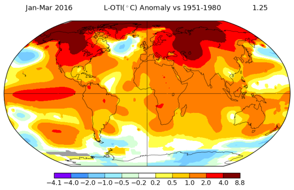
(According
to NASA, the first three months of 2016 were 1.25 C above the NASA
20th Century baseline and a ridiculous 1.47 C above the 1880 through
1899 preindustrial average. Image source: NASA
GISS.)
As
a result, 2016 will likely have jumped by about a quarter of a degree
Celsius in a single year.
If every year from 2016 on warmed up so fast the world would surpass
the dreaded 2 C mark by 2019 and rocket to about +22 C above 19th
Century averages by 2100. That’s not going to happen. Why? Because
natural variability assisted greenhouse gas warming from fossil fuels
to kick 2016 higher in the form of a serious heavyweight El Nino. But
it’s a decent exercise to show how ridiculously fast the world is
expected to warm from 2015 to 2016. And in the 2014-2016
string of three record warm years in a row we
are basically expecting a 0.40 C jump above the then record warm year
of 2010.
Given that the world has warmed, on
average by about 0.15 C to 0.20 C per decade since the late 1970s,
what we’re expecting to see is about two decades worth of warming
all cram-jammed into the past three years.
More
Severe Arctic Heat is on the Way
But
the Earth, as of this Earth Day, hasn’t warmed evenly. A far, far
greater portion of that excess heat has stooped over the
Arctic. During
the first three months of 2016, the Arctic region above 66 degrees
North Latitude has
been fully 4.5 C hotter than the NASA 20th Century baseline.
That’s a departure more than three times that of the rest of the
Earth. And that’s bad news for anyone concerned about sea ice, or
polar bears, or Arctic carbon feedbacks, or predictable seasons, or
extreme droughts and floods, or the Jet Stream, or Greenland melt, or
sea level rise, or … well, you get the picture.
One
region, at the boundary between the Arctic Ocean and the Greenland
Sea near Svalbard, has been particularly warm. So
warm, in fact, that
sea surfaces now devour slabs of Arctic Ocean ice blown into it by
winds running out of the Arctic in a matter of days.
It takes a lot of ocean warmth to have this kind of effect on sea
ice. A particularly ferocious amount of heat for the ocean to exhibit
so early on in the melt season.
(Neven
posted this excellent blog tracking
a ferocious amount of heat in the region of the Greenland and Barents
Sea. Arctic Sea Ice Forum commenter Andreas T provided this graphical
representation of sea ice disintegration as it was blown into waters
just to the north of Svalbard earlier this week.)
Perhaps
the easiest way to illustrate how relatively hot the Arctic is now is
the fact that sea ice in the region is melting fast. So
fast that current extent measures by JAXA are at their lowest levels
on record.
It’s a precipitous rate of melt that’s
about one week ahead of any of the previous fastest melt season.
Or you could just look at the
number of Arctic freezing degree days recorded at CIRES and
find one more measure added to NASA or record low sea ice pointing
toward the obvious fact that this year, for the Arctic, has been one
of just absolutely ludicrous warmth.
As
Winter progresses into Spring, temperatures typically moderate —
closing in on baseline averages. And this year has been no exception.
However, readings for the entire Arctic have tended to range between
1.5 and 2.5 C above average over the past two weeks. These are some
seriously hot departures for Spring. Enough to keep Arctic heat in
record ranges for 2016.
Three
Powerful Warm Wind Events to Strike the Arctic in Concert
But
over the coming five days, a series of south-to-north warm wind
events is expected to push even these seasonally excessive readings
higher.
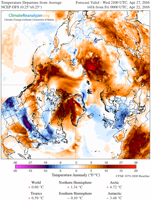
(GFS
model forecasts predict Arctic temperatures to rise into a range
between 3 and 5 C above normal for this time of year over the coming
week. Such departures are in record ranges and will likely result in
rapid snow and sea ice melt even as it drives a wedge of cold air out
of the Arctic and over Europe — setting up a high risk of very
severe weather events. Image source: Climate
Reanalyzer.)
The
first event is predicted to originate over the Yamal Peninsula of
Russia during Saturday and Sunday —
lasting on into Monday and Tuesday. There, temperatures are expected
to rise into the (scorching for the Arctic at this time of year) mid
30s (F) as strong, warm winds blow over about 1,000 miles of western
Russia and on up into the Kara and Laptev seas which are predicted
to, likewise, experience near or above freezing temperatures. Over
the entire region, temperatures are expected to range between 18 and
36 degrees F (10-20 C) above typical daily averages for this time of
year. Snow and sea ice melt melt rates in this already rapidly
thawing region will almost certainly pick up pace in the face of
these obnoxiously unseasonable readings.
A
second warm wind event is predicted to heat up Greenland, Baffin Bay,
the mouth of Hudson Bay and a chunk of the Canadian Archipelago on
Monday and Tuesday.
A 1,500 mile synoptic southeast to northwest air flow is expected to
originate in the Central North Atlantic. Running along the back of a
high pressure system rooted between Iceland and Southeastern
Greenland, these winds will ram a broad front of above-freezing airs
over a rapidly melting Baffin Bay, dramatically warm the southern 2/3
of Greenland, and flush a comparable warm air pulse into the outlets
of Hudson Bay. Temperatures in this broad zone are also expected to
hit 18-36 F (10-20 C) above average readings. And its effects will
likely be strong enough to initiate another strong early season melt
spike for Greenland in addition to aiding in driving a quickening
pace of melt for Baffin and Hudson bays.
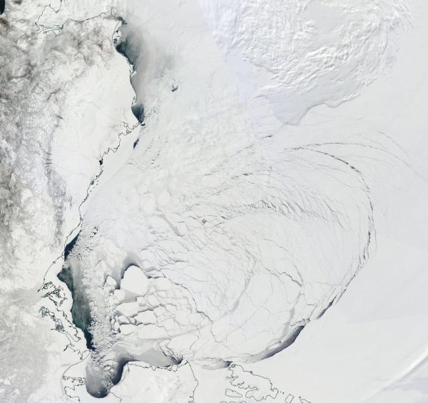
(Shattered
sea ice over the Beaufort and Chukchi looks as if it’s been
fractured from a blow from Thor’s mythical hammer Mjolnir. Open
water and very thin ice openings stretch as wide as 60 miles in some
sections. A warm wind event later this week is expected to provide
still more melt pressure to this already greatly weakened sea ice.
Image source: LANCE
MODIS.)
A
final warm wind event will be fed by a big warm up across Alaska
predicted to settle in on Wednesday and Thursday.
There, temperatures in Central Alaska are expected to rise into the
lower 60s as two stalled out lows to the south pull warmer airs up
from the Pacific Ocean. This heat is expected to invade the Chukchi
and Beaufort seas driving temperatures to near or above freezing over
Arctic Ocean surfaces that have already witnessed a great shattering
of ice and an opening of dark, heat-venting open water holes. There
the anomaly spike will be slightly milder — in the range of 15-32 F
(8-18 C) above average. Such heat will provide melt stress to the
fractured Beaufort, likely making more permanent the wide array of
open water and thin ice spaces as the push toward Summer advances.
Mangled
Jet Stream to Bring Storms to Europe
As
all this heat bullies its way into the Arctic, a flood of cold air is
expected to flee out of the region and on down a big dip in the Jet
Stream — making a late-season invasion across the North Atlantic
and into Europe. There, as we’ve seen previously during recent warm
wind invasions of the Arctic during Fall, Winter and Spring, warm air
from the south tends to cause cold to break out and then to dive down
the trough lines. And there’s a huge trough predicted to dig in
over Europe.
We
should expect some rather severe weather to accompany this Springtime
onrush of colder air — including potentially extreme thunderstorms,
flooding, and even instances of late April snowfall over parts of
Norway, Sweden, Scotland, the Alps, and sections of Germany.
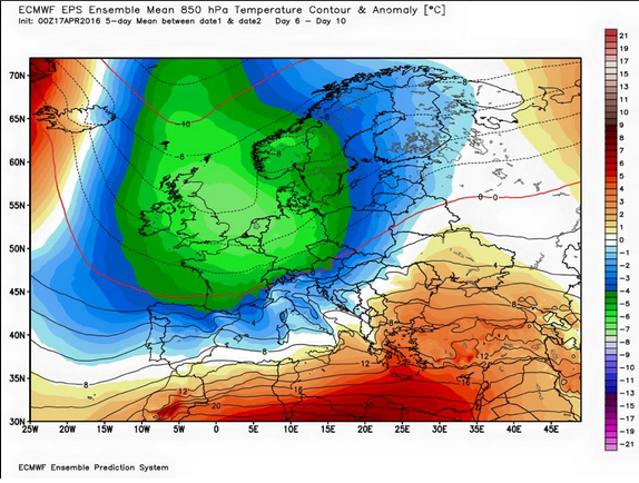
(A
very deep Arctic trough is expected to dig into Europe and the
Mediterranean later this week bringing with it the likelihood of some
very severe weather. Image source:ECMWF/Severe
Weather EU.)
Likely
increased rates of sea ice melt, a severe blow to record low snow
packs around the Arctic and a likely freakish cold air and severe
weather invasion of Europe are all a result of this extreme Arctic
heat playing havoc with typical weather and seasonality. By
the middle of next week, temperature anomalies for the entire Arctic
may rise to as high as 5 C above the already much warmer than normal
1981 to 2010 average.
In such a case, we could hardly expect weather or climate conditions
to be normal and there appears to be a big helping of weirdness and
extreme effects coming down the pipe over the next seven days.
Links:
Hat
Tip to DT Lange
Hat
Tip to Andreas T


No comments:
Post a Comment
Note: only a member of this blog may post a comment.