

NASA: Monster El Nino + Climate Change Means ‘Not Normal’ Winter is On the Way

13
October, 2015
“Over
North America, this winter will definitely not be normal. However,
the climatic events of the past decade make ‘normal’ difficult to
define.” — Bill Patzert, climatologist at NASA’s JPL
speaking in Earth
Observatory today.
****
It’s
official, as of this
Monday’s weekly NOAA ENSO report,
a still growing 2015 El Nino had taken yet one more step into monster
event territory.
Hitting a
+1.5 C sea surface temperature anomaly in the benchmark Nino 3.4
zone over
the period of July through September even as weekly values rocketed
to an amazing +2.4 C above average, the 2015 El Nino heightened yet
again — making a substantial jump in overall ocean heat content.
But according to a
recent report out of NASA’s Earth Observatory,
it appears we’re just beginning to see the full potential of this
thing.
As
Big or Bigger in Ocean Heat Content Than 1997-1998
For
the 2015 El Nino, an event that NASA
scientists are now calling ‘too big to fail,’ appears
bound to continue strengthening through late Fall and Early Winter.
Growing into a climate and weather wrenching oceanic and atmospheric
heavyweight that will significantly impact North American weather
patterns during the Winter of 2015-2016. This extreme climate event —
which is currently building to an extraordinary ocean heat content
anomaly in the Central and Eastern Pacific — is now comparable to
the top three strongest El Ninos on record. In other words, and
according to NASA: “El
Niño is strengthening and it looks a lot like the strong event that
occurred in 1997–98.”

(Sea
surface height anomaly graphic provided by NASA shows a pattern very
similar to 1997. Positive ocean surface height anomalies, indicated
in red above, are the hallmark of an El Nino that is currently ranked
among the top three strongest events observed for October. Image
source: NASA.)
Ocean
surface heights, as seen in the Earth
Observatory graphic above,
now show a pattern very similar to the monster 1997-1998 El Nino.
In
a typical El Nino, Kelvin Waves transfer Equatorial Pacific Ocean
heat from west to east which in turn sets off a rise in sea surface
heights by thermally expanding the water column throughout the
traditional Nino zones. And during the Fall of 2015 what we’re
seeing is a big thermal and related ocean surface bulge swelling seas
throughout the Eastern and Central Equatorial Pacific. To this
point, Earth
Observatory notes:
“October sea level height anomalies show that 2015 is as big or
bigger in heat content than 1997.”
Strong
Westerly Wind Burst Lends More Energy to El Nino
Supporting
NASA’s conclusions that El Nino intensity during 2015-2016 may hit
near or beyond the top of the chart is a recent intensification of
westerly winds over the Western Equatorial Pacific. Throughout 2014
and growing into 2015, these westerly wind bursts have fed El Nino by
pushing warmer, Western Pacific waters eastward — thus increasing
ocean heat content in the El Nino zone to near record levels.
Over
the past week, another very strong westerly wind burst was again
supplying El Nino with a warm water recharge. By tomorrow, the Global
Forecast System model shows not one but four cyclones driving a
strong westerly wind pattern from the Philippines all the way to the
Date Line:

(Yet
one more strong westerly wind burst is providing the already powerful
2015 El Nino with another boost. Note the extensive reverse trade
wind pattern stretching all the way to the Date Line. Image
source: Earth
Nullschool.)
It’s
a pretty significant westerly wind pattern — near to par with some
of the related weather events (MJO) earlier this year that were among
the strongest in the meteorological record.
These winds will rise to near gale-force gusts in some regions and
provide a dominant fetch from west to east across a 1,500 mile
section of Pacific Ocean. According
to NASA:
“This [weakening of the trades] should strengthen this El Niño. All multi-model averages predict a peak in late fall/early winter. The forecaster consensus unanimously favors a strong El Niño…Overall, there is an approximately 95 percent chance that El Niño will continue through Northern Hemisphere winter 2015–16.”
Not
Normal Winter Weather on the Way
A
typical powerful El Nino of this kind would tend to drive a very
intense train of moisture into the West Coast of the US, make for a
cool and very wet winter across the southern US, and drive warmer
temperatures and drier conditions across the northern tier.
Climatologists, however, are uncertain how interactions between the
current powerful El Nino and a globally changing weather pattern set
off by a human-forced warming of the atmosphere to 1 C above 1880s
levels (or about 1/4th the difference between the 20th Century and
the last ice age, but on the side of hot) will interact.
Very
warm sea surface temperatures, likely
due to both a climate change-forced heating of ocean surface waters
and a weakening of the Gulf Stream,
off the Eastern Seaboard hint that storms along the US East Coast and
particularly for the US Southeast may hit extreme intensity if an El
Nino associated trough digs in. Meanwhile extraordinarily intense sea
surface temperature anomalies in the range of +2 to near +6 C above
average off the US West Coast associated with a
‘hot blob’ that has lingered in this region for many seasons has
caused some to question whether California will see the high
intensity rainfall events typical of powerful El Ninos during the
latter half of the 20th Century.
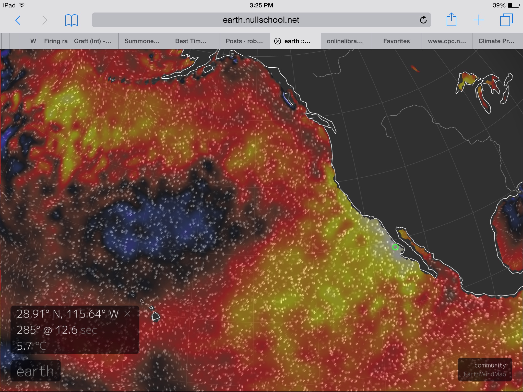
(Extreme
sea surface temperatures off the US West Coast can generate a kind of
atmospheric inertia in which high pressure systems tend to develop —
deflecting or weakening storms moving across the meridional Pacific
northward toward Canada, Alaska and even the Polar region.
Alternatively, an El Nino strong enough to over-ride this ocean and
atmospheric block is likely to generate some very extreme storms —
spurring events possibly exceeding those in the modern climate
record. Image source: Earth
Nullschool.)
For
the US West Coast, the region may be balancing on a razor’s edge.
If El Nino is strong enough to overwhelm the atmospheric and ocean
inertia generated by the hot blob, storms running into that region
could be extremely intense. On the other hand, if the hot blob holds
or deflects the moisture stream northward, California may not see a
drought-busting delivery of rainfall (See
Godzilla El Nino vs the Hot Blob).
“[The]
elements of our changing climate are too new to say with certainty
what the winter will bring.”
A
pretty significant statement when one begins to fully take in its
meaning — that climate change may be starting to set weather
forecasting out of the context of the latter 20th Century. That it’s
NASA’s view that aspects of modern weather prediction for El Nino
events may have already been set off kilter by ‘elements of our
changing climate.’
New
Global Temperature Records For 2015 Likely a Lock
But
what we do know is that the ocean-to-atmosphere heat back-up
generated by what could be a record El Nino, when combined with the
enormous added heat forcing provided by human fossil fuel emissions,
will almost certainly set new global high temperature records for
2015 and possibly for 2016. This, unfortunately, means that we’ve
already started on a dangerous path toward the far more disruptive
+1.5 and +2 C above 1880s benchmarks.
A range that many scientists associate with a greatly increased risk
of hitting climate
tipping points.
Links:
No comments:
Post a Comment
Note: only a member of this blog may post a comment.