Patricia’s Epic Bombification — Monster El Nino + Climate Change Serves Up Strongest Western Hemisphere Hurricane Ever
Now
this is scary. A tragic development you’d tend to see in a disaster
movie screenplay and not in any typical meteorological record for any
36 hour period. But here we have it.
23
October, 2015
Patricia,
as of 36 hours ago, was a rather mild tropical storm churning through
the human hothouse and El Nino warmed Eastern Pacific. The storm was
predicted to make landfall in Western Mexico as a hurricane, then
turn north into Texas, Louisiana and Mississippi — dumping extreme
rains over a drought stricken region. But there was little hint as to
what would happen next.
(Patricia
becomes the strongest Western Hemisphere storm ever recorded as it
sets sights on a swath from the Pacific Mexican Coast and on through
to Texas, Louisiana, Mississippi and Arkansas. Video
Source.)
Favorable
atmospheric conditions and next to zero wind shear set the stage for
strengthening. But the main driver was the hot ocean water which
Patricia could tap as fuel for rapid intensification. For the entire
region now features ocean surface temperatures in the range of 30 to
31 C (86 to 88 F) or about 2-3 degrees Celsius above average. It’s
heat fed by an El Nino that could be one of the top three strongest
on record. Heat further intensified by a human forced warming of the
globe that has now hit about 1 C above 1880s levels. Heat that would
allow Patricia to hit never before seen heights of storm force in a
period of extraordinarily rapid intensification.
They
call it bombification for a reason. Pressures drop rapidly, wind
speeds rage to epic force, and the storm presents a tell-tale angry
red signature in the infrared satellite shot. During recent years,
bombification has become an all-too-common word associated with ocean
storms that are now feeding on unprecedented amounts of heat,
moisture, and temperature differentials. Some have even claimed that
Hansen’s terrifying ‘Storms of My Grandchildren’ are starting
to arrive early. But what happened with Patricia was even outside the
new abnormal bombification ‘norm.’
Though
weather models did forecast a rapid strengthening for Patricia,
the kind of strengthening we ended up with was something both
freakish and extraordinary. In a 36 hour period pressures plunged
from a mild 990s mb storm to a system featuring an 880 mb minimum
central pressure. This raging period of ocean-shattering
intensification propelled Patricia to a dubious status of most
intense storm ever recorded for the Western Hemisphere over centuries
of barometric readings. Winds also rapidly strengthened — roaring
up from 40 miles per hour to a current top intensity of 200 miles per
hour. That’s 160 mph of wind intensification in a little more than
36 hours.
At
current intensity, the storm is now comparable to the monster western
Pacific Storms — Haiyan (195 mph and about 890 mb) and Tip (195 mph
and 870 mb) — otherwise known as the strongest storms ever
recorded. And all this fury now aimed at a well-populated swath from
the Pacific Coast of Mexico through to the Gulf Coast of the United
States.
An
Unimaginably Dangerous Storm Following a Ridiculously Dangerous Path
The
potential for tragedy in this situation cannot be understated. A
similar strength Hurricane Haiyan — also fueled by abnormally hot
waters made hotter by human-forced warming — rendered tens of
thousands homeless even as it resulted in the horrible loss of 6,000
souls.
Patricia
falls into this high-danger category for a few reasons. The first is
that the storm is expected to maintain its extreme Category 5
intensity all the way through to landfall — which is predicted to
occur within the next 10-12 hours. Abnormally intense ocean heat
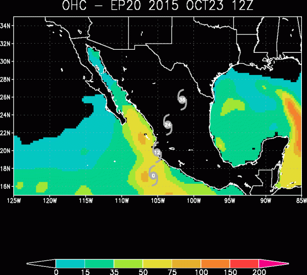
content along the path of Patricia, as seen in the graphic below,
will continue to provide the powerful storm with fuel as it
encroaches upon the Mexico Coast.
As
a result, a 15-30 mile swath of the Mexican coast may experience
sustained winds near or in excess of 200 mph with gusts up to as high
as 250 mph. That’s tornado intensity winds but spread out over an
area the size of a small state. Storm surges and related onshore
waves are expected to be ‘catastrophic’ (the National
Hurricane Center’s words).
How catastrophic is unclear (no specific surge height predictions are
given), but taking such extreme wind speeds and low pressures into
account, we could certainly expect surges near and to the right side
of the storm center to be in excess of 20 feet.
As
Patricia begins to interact with the mountainous terrain near the
coast, it should begin to weaken even as it dumps heavy rainfall over
a broad region. Already, moisture and storm outflow from Patricia are
being caught up in the Jet Stream and pulled north and eastward over
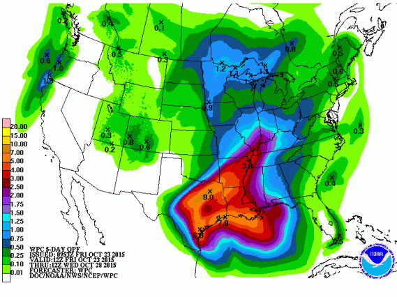
Texas. By Sunday, the remnants of Patricia are expected to combine
with a non-tropical cyclone which is predicted to, in turn, dump
between 5 and 9 inches of rain over a wide section of Texas,
Louisiana and Arkansas.
(NOAA
5 day precipitation forecasts show severe rains hitting drought
stricken regions of Texas, Arkansas and Lousiana as the remnants of
Patrica track northward. Image source:NOAA.)
These
rains will provide yet one more weather whiplash to a region that
experienced severe flooding this past Winter and Spring only to be
replaced by severe flash drought conditions and extreme wildfire
outbreaks during late summer and early fall. Patricia’s expected
flooding rains will begin what is expected to be an extremely wet
Winter for the region — providing no relief for the highly varied
conditions that have impacted the region for some time now. The kind
of extreme weather variation that scientists warned was also a
potential upshot of human-forced climate change. And, in this case, a
record strength storm fueled by a near record El Nino, forming in a
record hot world, and feeding on record hot Pacific Ocean waters is
the delivery mechanism for the predicted switch.
(Updates
to Follow)
Links:
Hat
Tip to DT Lange
Hat
Tip to Greg


No comments:
Post a Comment
Note: only a member of this blog may post a comment.