Frailest-Ever Winter Sea Ice Facing a Cruel, Cruel Summer
This
past weekend, it rained over the ice of the late winter Kara
Sea.
Falling liquid drops that whispered of the far-reaching and
fundamental changes now occurring at the roof of our world.
*****
20
March, 2017
For
an Arctic suffering the slings and arrows of human-forced global
warming, the winter ended just as it had begun — with an
ice-crushing delivery of warm air from the south.
A
burly high pressure system over Russia locked in an atmospheric
embrace with a series of low pressure systems stretching from the
Barents Sea down into Europe. Winds, originating from the
Mediterranean rushed northward between these two opposing weather
systems — crossing the Black Sea, the Ukraine, and swirling up over
Eastern Europe. The winds wafted warm, above-freezing air over the
thawing permafrost of the Yamal Peninsula. And the frontal system
they shoved over the melting Arctic sea ice disgorged a volley of
anomalous late-winter rain.
(Another
ice-melting warm wind invasion rushes into the Arctic — this time
through the Kara and Laptev Seas. Image source: Earth
Nullschool.)
As
this rain hissed over the ice, delivering a load of heat to its
fractured and frail surface, temperatures above the Kara
Sea rose
to 1 to 2 C — or about 25 to 30 C warmer than average (42 to 54 F
warmer than normal). Meanwhile, the frontal boundary lofted by the
warm winds rushed on — pushing above-freezing temperatures all the
way into the Laptev
Sea north
of Central Siberia.
This
most recent rush of warm air to the ice edge region came as a kind of
herald for the start of melt season. Melt season start is an event
that takes place every year at about this time. But during 2017, the
sea ice set to begin this annual melt has never been so weak. The
fall and winter warmth has been merciless.
Month after month of far warmer than normal temperatures have pounded
the ice. And now both sea ice extents and volumes are lower than they
have ever been before — or at least since we humans have been
keeping track.
Third
Consecutive Record Low Sea Ice Extent Maximum
Neven
and the sea ice observers over at The Arctic Sea Ice blog produced
the following graph depicting what is all-too-likely to be a 2017 in
which the sea ice extent maximum just hit another consecutive annual
record low:
(2015,
2016 and 2017 were three consecutive record low winter maximum years
for sea ice extent in a row. Image by Deeenngee and The
Arctic Sea Ice Blog.)
After a drop of almost 262 thousand km2 in just three days, it looks highly likely that the maximum for sea ice extent was reached two weeks ago, according to the data provided by JAXA, the Japan Aerospace Exploration Agency (via ADS-NiPR ; it used to be provided by IJIS).
As
melt season starts, another record low for sea ice extent maximum
raises some serious concerns. The less ice that covers the ocean, the
more dark blue surface is left open to absorb the sun’s rays. And
this loss of ice poses a problem in that a less ice covered Arctic
Ocean can take in more heat during melt season — which can serve as
an amplifier for melt rates.
During
2016, Arctic sea ice extent also hit a record low maximum. But this
thankfully did not translate into new record lows by the end of
summer melt season. Weather, as ever, plays its part. And there is
some evidence to indicate that increased cloud cover caused by higher
levels of water vapor above the Arctic may help to shield the ice
somewhat during warmer months. A feature, however, that
did little to prevent severe sea ice losses during the record summer
melt of 2012 in which a powerful Arctic cyclone also played a roll in
ice melt.
Arctic
Sea Ice Volume Looks Considerably Worse
Sea
ice extent is the measure of how much ocean the ice covers to its
furthest-reaching edge. But it’s not the only measure of ice.
Volume, which is a measure of both sea ice area and thickness,
probably provides a better overall picture of how much ice is left.
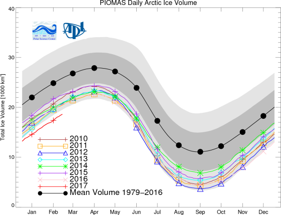
And the picture of sea ice volume going into the melt season for 2017
isn’t looking very good at all.
(Arctic
sea ice volume through late February was tracking well below trend.
This considerable negative deviation presents considerable risk for
record low sea ice measures by the end of 2017 melt season. Image
source: PIOMAS.)
Sea
ice volume is now tracking about 2,000 cubic kilometers below the
previous record low trend line for this time of year. In other words,
the trend line would have to recover considerably over the coming
months in order to not hit new record lows by the end of this melt
season (September of 2017).
What’s
happened is that the ice has experienced three consecutive very warm
winter periods in a row — 2015, 2016 and now 2017. And a resulting
considerable damage to the ice increases the risk that new all-time
record lows will be reached this year. If the present volume measure
remains on track through end of summer, sea ice volume could well
split the difference between 2012’s record low of approximately
4,000 cubic kilometers of sea ice volume and the zero sea ice volume
measure that represents an ice-free Arctic.
Cruel
Summer Ahead
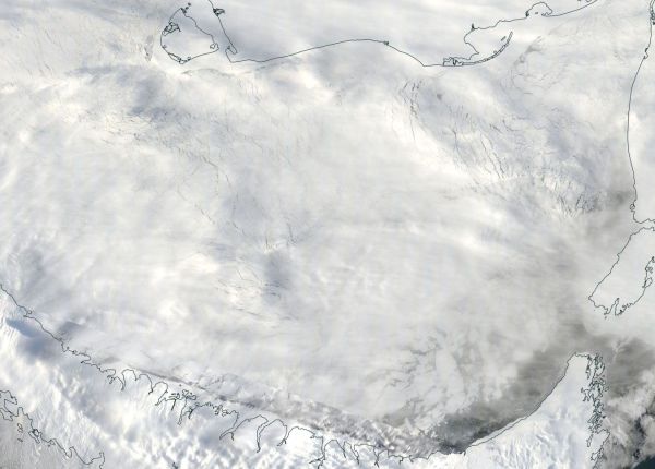
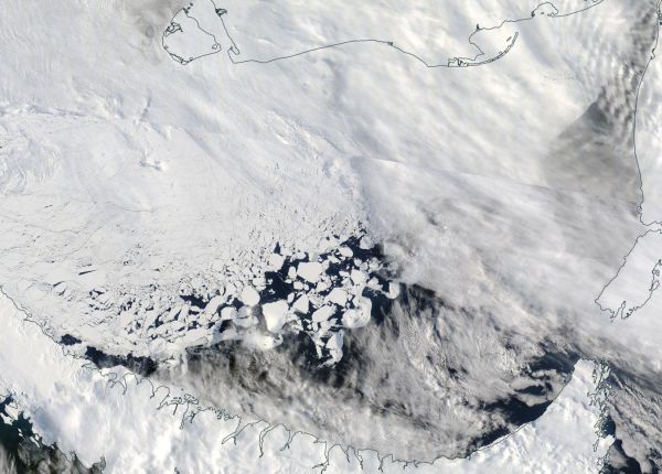
(Warm
winds, above freezing temperatures, and rain caused considerable sea
ice retreat in the Kara Sea from March 14 [top frame] to March 20
[bottom frame]. This event may well have been the herald to a record
spring and summer melt during 2017. For reference, bottom edge of
frame is 300 miles. Image source: LANCE-MODIS.)
This
discussion is worth consideration given how much heat we’ve seen in
the Arctic recently. However, we are unlikely to see such a neat
progression. Spring and summer surface temperatures could track
closer to normal ranges and cloudy (but not overly stormy) conditions
could give Arctic albedo an assist — causing the melt rate to lag
and pulling the volume measure closer to the trend line. But, it
could also vary in the other direction. For post La Nina (we have
just exited a weak La Nina) the ocean gyres tend to speed up —
which enhances sea ice export — even as more heat tends to
transport in the final post El Nino plume toward the poles.
If
this particular form of inter-annual natural variability trend toward
warmth and melt in the Arctic takes hold during 2017, then we will
have less chance to see a spring and summer sea ice recovery toward
the trend line. And this is one reason why we’ve been concerned
since 2015 that 2017 or 2018 might see new record lows during the
summer for Arctic sea ice.
Links:
Hat
tip to Suzanne


No comments:
Post a Comment
Note: only a member of this blog may post a comment.