‘Wall of water’: Slip dam breached on New Zealand river, residents urged to seek higher ground

A
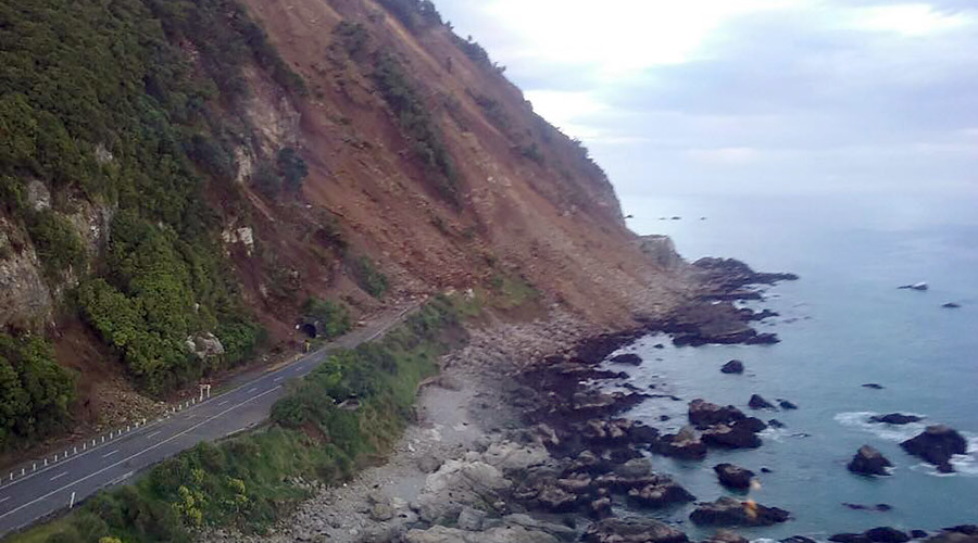
handout photo taken and received on November 14, 2016, show
earthquake damage to State Highway One near Ohau Point on the South
Island's east coast. © Ohau Point / AFP
RT,
14 November, 2016
Residents
of the Marlborough region of New Zealand have been urged to go to
higher ground immediately, after a slip dam breached on the Clarence
River following a powerful earthquake and series of aftershocks.
Emergency
workers began evacuating residents at around 3:30pm local time on
Monday, before the slip breached, as a precautionary measure, the New
Zealand Herald reported.
Authorities
are currently searching for a group of kayakers thought to have moved
to higher ground after their gear was found close to the river bank,
Marlborough civil defence said on Twitter. A separate group of 16
rafters, previously believed missing, has been contacted by rescuers
and are safe.
The
water is likely to flow at 1,000 m3/s to 2,000 m3/s, far exceeding
once-in-a-decade flood volumes, according to Environment Canterbury.
It would take three to five hours for the “wall
of water” to
travel the length of the river and reach the coast,
stuff.co.nz reported.
Located
on South Island, New Zealand, the Clarence River is 230 kilometers
(140 miles) long, making it the eighth longest river in the country.
It
comes after a powerful 7.8 magnitude earthquake struck South
Island just after midnight local time on Monday, triggering a tsunami
and a series of aftershocks which left at least two people dead.
18:13
UPDATE:
Latest from Marlborough Civil Defence:
A
group of kayakers thought missing on the Clarence River are safe.
The
group were evacuated from the river earlier today and reported their
whereabouts a very short time ago.
Helicopters
were searching for this group after their gear was discovered on the
river bank late afternoon. A group of 16 rafters has also been found
safe. There was concern about the safety of both groups after water
broke through the slips that had been blocking the river, sending big
volumes of water down the river.
The
first coach load of stranded travellers from the Ward Emergency
centre has now arrived safely in Blenheim.
They
disembarked at the Blenheim i-SITE Visitor Information Centre where
accommodation and travel arrangements were arranged by i-SITE staff.
There
are still 50 people at the Emergency Centre which is at the Ward
Community Hall which the Red Cross intends to keep operating to late
Wednesday if required.
The
Wairau Bridge on SH1 between Picton and Blenheim is due to reopen at
6pm.
Weather warning for region affected by earthquake
http://about.metservice.com/homepagerss/
MetService issues Weather News Releases to keep you up to date when the weather is of particular importance - such as severe weather, weather for special events or holiday periods, etc. You can sign up to receive these emails direct to your Inbox - just click on this link: News Email Sign Up
Issued
at 12:27pm Monday 14 Nov 2016
Severe
weather to hit during quake clean up
Severe
weather is expected to hit New Zealand later today, including a
number of areas affected by this morning's earthquakes. Severe
weather warnings have been issued for strong winds and heavy rain
developing this evening in central New Zealand, with gusts up to
140km/h expected in exposed places.
An
active weather system is approaching the lower South Island, with a
wedge of warm air from the tropics bringing heavy rain with it. Rain
is expected to be heaviest in northwest Nelson, Buller and Westland,
and also in the ranges of Marlborough Sounds, Taranaki, Tararua
Ranges and the headwaters from Whanganui to Ruapehu. Localised
downpours are possible, with a high risk of thunderstorms on the
West Coast of the South Island this evening until early Tuesday
morning. Areas in the east, including Kaikoura, will miss the worst
of this rain although scattered falls are likely there overnight
before clearing in the morning.
Northerly
winds will pick up this afternoon ahead of tonight's system,reaching
severe gale in Cook Strait this evening. The strong northerlies will
affect areas from Whanganui and Manawatu to Kaikoura, although the
strongest gusts will be closer to the Strait, including Wellington
where the quake clean-up is underway. Winds should peak in the
Kaikoura area tonight before easing into Tuesday morning, although
the week ahead will often be windy.
With
a full moon tonight, tides will be high and flooding is
possible,especially in the Nelson area around tonight's high tide at
10.30pm which coincides with strong onshore winds and heavy rain.
Areas on the Kapiti Coast and northern parts of the South Island's
West Coast should also beware of high wind waves during tonight's
high tide. Heavy rain could also lead to localised flooding tonight
in those areas of the upper South Island that are under severe
warnings and watches for rain.
The
rest of the week is marked by troughs from the Tasman bringing strong
winds and rain, especially in the west, although the wet week should
ease up by Friday.
Keep
up to date with the latest forecasts and any watches/warnings at
metservice.com or on mobile devices at m.metservice.com. You can also
follow our updates on MetService TV, at MetService New Zealand on
Facebook, @metservice and @MetServiceWARN on Twitter and at
blog.metservice.com


No comments:
Post a Comment
Note: only a member of this blog may post a comment.