Pair of Arctic Storms Sparked Severe Polar Warming, Sea Ice Melt for November 2016
Folks
— we’re in a climate emergency. Tell everyone you know.
— Eric
Holthaus
There
are weather and climate records, and then there are truly exceptional
events that leave all others in the dust. Such has been the case
across Earth’s high latitudes during this last quarter of 2016…
—
Bob Henson at WeatherUnderground
Global
warming doesn’t care about the election.
*****
The
dramatic Arctic warmth and related damage to sea ice continued today.
It’s a situation that Bob Henson at Weather Underground has aptly
dubbed ‘the
crazy cryosphere.’
But from this particular observer’s perspective, the situation is
probably worse than simply crazy. It appears that we are now in the
process of losing an element — Arctic sea ice — that is critical
to the integrity of seasonality as we know it.

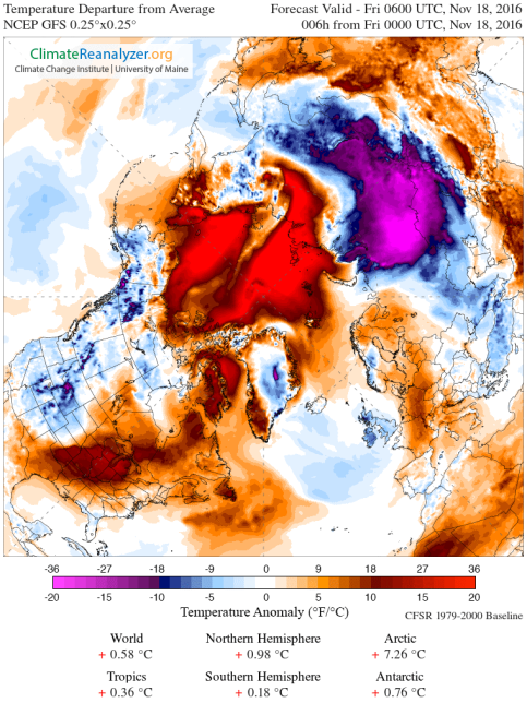
(Extreme
Arctic warmth was drawn in by two warm storms — one running north
from the Barents on November 14. Another emerging from Kamchatka on
November 16 and 17. Warm storms have, during recent years, run up
along high amplitude waves in the Jet Stream and into the Arctic
during both summer and winter — with apparent strong impacts to sea
ice [see NASA video below]. Image source: Climate
Reanalyzer.)
On
November 17, according
to Arctic sea ice expert Zack Labe,
the Arctic Ocean actually lost about 50,000 square kilometers of ice
coverage. This would be odd on any given November day — which
typically sees a trend of rapid freeze as the Arctic cools down into
winter. But it is particularly strange considering that the Arctic
Ocean is presently in a severe sea ice deficit of around 700,000
square kilometers below previous record lows. One that follows on the
heels of both a very warm October and an exceptionally warm November
for the Polar region of our world.
These
losses occurred just one day before overall temperature anomalies for
the climate zone above 66 degrees North Latitude went through the
roof. For today, according to Climate Reanalyzer, temperatures for
the entire Arctic spiked as high as 7.26 degrees Celsius above
average. This occurred even as readings near the North Pole hit to
near or above freezing in some locations.
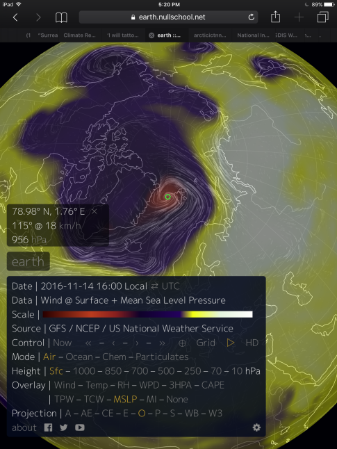
(Warm
Storm running up through the Fram Strait on November 14 — an event
which flooded the high Arctic with abnormal late fall heat. Image
source: Earth
Nullschool.)
And
though these warming events have been widely reported in climate
media, what has not been reported is the fact that a pair warm storms
similar to the one that hammered sea ice and brought North Pole
temperatures to above freezing during late December of 2015 were also
the triggers for the present Arctic Ocean warming event.
Such
intense warm air invasions can have a dramatic impact on sea ice.
According to NASA,last
year’s late December warm storm event resulted
in considerable ice thinning and melt over the critical sea ice
region surrounding the North Pole. Ice in the Barents was reduced by
10 percent. Sea surface temperatures in some locations jumped to 20
degrees (F) above average. And throughout the month of January, there
was little rebuilding of sea ice into the recently melted regions.
Approx 3-day sea ice loss in JAXA now 140,000 km^2. Nearly 1 million km^2 below past record low #seaice #climate #globalwarming
(A
recent NASA study found that warm storms can have a serious impact on
sea ice. And for both 2015 and 2016, this appears to be the case.)
This
year’s warming event was also accompanied by a storm running north
out of the Barents. On November 14, a 955 mb storm ran directly up
through the Fram Strait. It ushered in warm, moist winds from the
south which then spread northward over the Central Arctic —
bringing with them above freezing temperatures. On November 16, a 966
mb storm crossed over Kamchatka. It subsequently weakened. But it
still possessed enough oomph to pull in a strong plume of warmth and
moisture as it entered the Arctic Ocean near the region of the East
Siberian Sea. And the result has been a flood of warm air coming in
from the Beaufort and East Siberian Sea to meet with the similar
onrush coming from the Barents. The result is the huge Polar heat
spike that we see today.
Following
a very warm October, this is a kind of insult to injury situation for
the sea ice. And though temperatures are expected to fall back a bit
over the coming week in the High Arctic, atmospheric and ocean
conditions running into December seem to favor the potential for more
warm air influxes to this fragile climate zone.
UPDATE:
On November 19, it had become apparent that significant sea ice
losses were ongoing in the Arctic. According to the
JAXA sea ice monitor,
about 140,000 square kilometers of sea ice had been lost over the
period of November 16 through 18. As Arctic Ocean ice typically
freezes quite rapidly during November, such counter trend losses are
highly extraordinary. Now, sea ice in the Arctic, according to JAXA
is 995,000 square kilometers below the previous record low set during
2012.
NSIDC shows
similar losses in the sea ice extent monitor for the period of
November 16-18. In total, 170,000 square kilometers of ice has been
lost over the three day period and the total departure from the
previous record low in 2012 is now 702,000 square kilometers.
These
losses are quite extensive and, in many ways, are worse that those
that occurred following the December 27, 2015 warm storm event.
Links:
Hat
tip to June


 Robert Fanney


No comments:
Post a Comment
Note: only a member of this blog may post a comment.