Even a Monster El Nino Can’t Beat the Southwest Drought
10
February, 2016
For
those who follow weather, it’s a rather strange and disturbing
story.
A
powerful Pacific Ocean storm forms about 500 miles south of the
Aleutian Islands. Heavily laden with rains, strong winds, and
trailing a long squall line, the system takes aim at the US West
Coast. It’s a burly beast of a thing. Pumped up by an enormous
bleed of moisture rising off of one of the mightiest El Ninos ever
seen. An instance of extreme Equatorial heat that’s been firing off
since October.
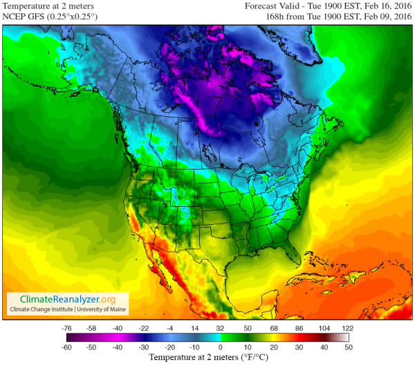
(Another
Pacific Storm is deflected northward by increasingly persistent high
pressure systems as the US Southwest swelters under unseasonable
warmth. GFS climate reanalysis by Climate Reanalyzer shows this
disturbing weather pattern again and again in the February forecast.
In short, it doesn’t look like the California Drought is going to
end anytime soon. Image source: Climate
Reanalyzer.)
The
towering El Nino-fed storm clouds chug east, steaming along toward
what appears to be an inexorable collision with California, Oregon,
and Washington. But, at the last moment, the storm slams into a heavy
pile of atmospheric heat. Warm air building over the US Southwest and
nearby ocean zones has shoved the upper air steering current called
the Jet Stream pole-ward. The great storm is sucked up into this
atmospheric train, delivering its rains along an arc from Washington
State on northward.
And
so the seemingly impossible has happened. A powerful El Nino’s
rains and snows — usually bound directly for California, Oregon and
Washington — have been diverted by a new kind of atmospheric
pattern associated with climate change.
El
Nino’s Rains Gone or Just Taking a Break?
Ever
since late January, strong ridges have tended to develop over Western
North America. By February 4th, the National Weather Service (NWS)
had begun to report on the pattern — describing it
as El Nino taking a 5-10 day break.
But the ‘break’ had
already begun to show up on January 26th —
about ten days prior to the February
4 NWS announcement.
And now, on February 10, we’ve seen two full weeks of warm, dry
weather settling in over California and the US Southwest. Meanwhile,
long range model forecasts indicate that the ‘break’ from El Nino
conditions will continue through at least February 16h.
(Temperatures
in the upper 60s to upper 80s is predicted for a large sections of
California and Arizona on Tuesday, February 16th. It’s the kind of
hot, dry air that brings back memories of recent years when
formations of strong, ridiculously resilient ridges pushed California
into one of its worst drought episodes on record. Image
source: Climate
Reanalyzer.)
It’s
all just terrible timing. First, California snow packs during
December and January began to recover due to strong, El Nino
associated, storm systems barreling in. However, now during what
should be the peak of the Southwestern rainy season, we have what
could be a month long pause in storms hitting the region. It’s
as if the rainy season is being hollowed out. And
not just any rainy season — a strong El Nino rainy season which
should have been far, far rainier than most.
Last
week, Climate Central and Peter Gleick — a climate expert at
Pacific Institue — made
the following warning:
…seven days of sustained warmth could melt as much as 30 percent of California’s snowpack. The hot, dry weather is exactly what baked in exceptional drought in California over the past four years. Some signs indicate the heat is driven in large part by climate change, but the role of the ridiculously resilient ridge is still an area of active investigation.
Well,
by tomorrow seven days will have come and gone. But the end to the
anomalous warm, dry spell is still nowhere in sight.
California
Drought Really Hasn’t Budged
Meanwhile,
a four-year-long California drought appears to be making a strong run
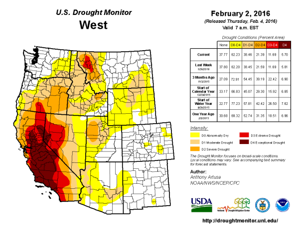
at year five. In fact, if you look at the
US Drought Monitor,
you’ll find that a large swath of the West is currently suffering
under moderate to exceptional drought conditions.
(Severe
Drought remains in place over the US West. El Nino appears to have
lost at least some of its ability to deliver heavy rains as an
intensifying regime of human-forced warming pushes typical weather
patterns further and further off-kilter. All bad news for an area
that has been suffering from one severe drought after another since
the early 2000s. Image source: Drought
Monitor.)
Quite
frankly, it’s insane that we’re still seeing these conditions
during a monster El Nino. These droughts should be rolling back as
the storm track intensifies and hurls severe weather at the US West
Coast. But that’s not what’s happening. At least not
consistently. Instead, we keep getting these extreme ridge patterns
in the Jet Stream over western North America. We keep getting these
very warm, very dry spells of weather during the wet season. And now,
we have California Snowpack melting away in February of all times.
A
Ridge-Trough Pattern That’s All-Too Likely Related To A
Human-Forced Warming of the Arctic
The
fact that these weather patterns emerged after
the warmest January and lowest sea ice extents on record for the
Arctic is
a point that should not be missed by weather and climate analysts. It
appears that what we are seeing is yet more evidence that polar
amplification is driving a consistent high amplitude bulge in the Jet
Stream over Western North America together with severe periods of
warmth, dryness and snowpack melt during Winter. The hot side of a
dipole pattern that is also setting up more extreme storm potentials
as cold air is driven out of the Arctic along a deep trough over the
Eastern US, slams into a record hot Gulf Stream, and
then sets off a series of atmospheric bombs along a storm track
running all the way across the North Atlantic and into Western
Europe.
Yet more evidence that what happens in the Arctic doesn’t stay in
the Arctic.
Links:
Hat
Tip to DT Lange
Hat
Tip to Andy in San Diego
Hat


No comments:
Post a Comment
Note: only a member of this blog may post a comment.