

Hothouse Summer is Coming — Lingering California Drought, Record-Shattering Heat in Washington, and Thunderstorms Pounding the Northwest Territory in April
19
April, 2016
Writing
about human-forced climate change isn’t easy. And, lately, year
after year, I’ve grown to dread these three words more and more
— Summer
is Coming.
This
year, it’s worse. The gateway of Equatorial-to-Polar heat transfer
was thrown wide open as one of the strongest El Ninos on record
blazed through the Pacific.
As a result, Winter temperatures in the
Arctic hit levels that were likely never seen by any human that has
ever lived in a settlement resembling a town or a city. And one of
the paths over which this heat ran was Western North America. A
region that is now experiencing a number of early warning signs that
trouble is on the way.
*****
What
was perhaps the strongest El Nino on record is now fading in the
Equatorial Pacific. It was an event that many hoped would provide
significant relief to a drought-stricken California. An event that
many hoped would crush a hot zone of Northeastern Pacific waters
dubbed ‘The Blob’ — providing a new skein of cooler and far
more familiar ocean surfaces. An event that many hoped would return
at least some sense of normalcy to the US West Coast by restoring
snow packs, reservoirs and flattening the Jet Stream while
re-establishing a typical west-to-east storm progression.
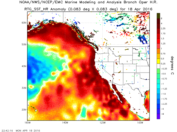
(Ridiculously
warm sea surfaces remain in place off the US West Coast. There, sea
surface temperatures are in the range of 1-4 degrees Celsius above
typical 1961 to 1990 readings. Such warm seas will tend to aid in
ridge formation through Alaska and Western North America as Spring
progresses into Summer. During recent years, a synergy has tended to
develop between these abnormally warm waters, the warming and melting
Beaufort Sea to the North, and the development of brutish, hot high
pressure systems over the region. Image source: NOAA/NCEP.)
Unfortunately,
many of these hopes have failed. The California drought remains
firmly entrenched. Sea surface temperatures off the US and Canadian
West Coasts remain abnormally high. And record-shattering heat and
extreme weather is again settling in over Western North America
during Spring. Though heavy rains and snows across Washington and
Oregon during Winter have replenished higher elevation snowpacks
there, an overall tendency for much warmer than normal conditions
remains. And far to the north, the early break-up of Beaufort Sea Ice
hints that any hopes for a return to flattened Jet Stream patterns
may well be in vain.
This
isn’t to say that the Summer of 2016 will be an exact mirror to
that of 2015. More that newly established and climate change related
trends promoting extreme warmth, southwest drought, Arctic wildfires,
abnormal ocean heat and thunderstorms in the far north remain in
place and are likely to have a continued and often disturbing impact
this year. Perhaps even more-so after a recent Winter of record
Arctic heat and a long period of abnormal warmth that has prepped a
wide zone for potentially very severe warming-related weather in the
months to come.
And
already, it seems that weird Spring and Summer weather associated
with a human forced warming is starting to settle in.
Freak
Thunderstorms in the Northwest Territory
On
Monday, extreme heat in the range of 15-35 degrees (Fahrenheit) above
average settled in over much of Western North America. A
strong upper level ridge of high pressure flexed its muscles over a
broad swath stretching from California to the edge of the Arctic. All
across Western Canada, unseasonably warm winds blew from south to
north, carrying with them heat, moisture, and instability. Where the
head of this roiling warm air mass collided with colder airs swirling
over the Arctic Ocean — atmospheric sparks began to fly.
Residents
of the Northwest Territory town of Yellowknife were amazed as an
abnormal, early thunderstorm roared through the region —
sparking off staggering displays of lightning and heavy downpours
over the still-thawing lands.
The storm emerged over the western edge
of Great Slave Lake. It then rumbled past communities like Fort
Providence, Kakisa, and Hay River, before finally thundering
east over Yellowknife.
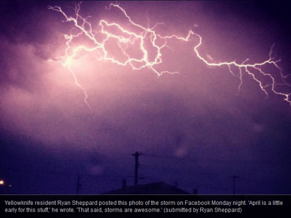
It
was an abnormal display that left many onlookers, including to city
mayor stunned. “Um, there’s lightning. In Yellowknife. In April.”
A flabbergasted Mark Heyck tweeted
yesterday evening.
April
thunderstorms are a more typical feature of the Great Plains of the
US during this time of year. And it wasn’t until recently that
human-forced global warming began to make these powerful storms a
more frequent possibility for this near-Arctic region even during
Summer. How unusual thunderstorms used to be for this region is
driven home by the fact that tribes indigenous to the area didn’t
even have a word in their language to describe them. For the early to
middle spring period, it’s a 1 in 30 year event to see a
thunderstorm over Yellowknife even when taking into context a very
warm 20th Century. So back then it was basically a once or twice in a
lifetime happening. But that was before a record global heating
driven by fossil fuel burning settled into its warmest levels since
the peak of the Eemian more than 115,000 years ago.
Now, it’s pretty certain that such events will continue to become
more common.
Never-Before
Seen April Heat in Washington
About
700 miles to the south, Seattle, Washington experienced its
highest-ever April temperatures in 122 years on Monday.
There, readings rocketed to an extreme 89 degrees (Fahrenheit) as a
powerful blocking high pressure system trapped a hot, stagnant air
mass over the region pushing thermometers well above the 90 degree
mark in many locations.
Yesterday’s
Seattle high temperature reading was an amazing 31 degrees (F) above
average for this time of year and a full 4 degrees (F) above the
previous all-time record for the month of 85 degrees set on April
30th in 1976 — or nearly two weeks later in the season. Monday was
also the second day in a row of above 80 degree temperatures. If
today’s readings rise to their predicted values of 84 (F) then
it will be the first time ever in April that there were three
unbroken days of 80 degree or above in that Pacific Northwest City.
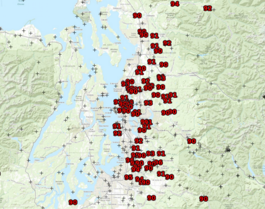
(Extraordinary
spate of above 90 degree temperatures breaks out in Northwestern
Washington yesterday. These are never-before seen readings for a
region that typically experiences much cooler weather in the upper
50s (F) during this time of year. It’s unprecedented for April.
Something that is an upshot of a severe and outlandish human forced
warming that is resulting in more and more freak weather events
cropping up around the globe. Image source: The
National Weather Service and The
Capital Weather Gang.)
The
weird Seattle heat was accompanied by extraordinarily high
temperatures running into the 90s throughout Puget Sound and over
much of Northwestern Washington. Bellingham and Olympia experienced
warmest ever April temperatures as well with thermometers hitting 83
and 88 (F) respectively. And in some locales, the proverbial mercury
climbed to as high as 96 degrees (F) or about 39 degrees above
typical April temperatures for the region.
To
say such hottest-ever temperatures are disturbing would be an
understatement. Though the region received strong rains and snows
throughout Winter, record heat in this range will tend to push
replenished mountain snows to rapidly melt and nearby forests to
flash-dry. An area celebrating this year’s influx of moisture could
thus soon find itself facing fire hazard and drought as Spring
progresses into Summer.
Even
a Strong El Nino Can’t Shake California from the Grips of Extreme
Drought
Still
further to the south, persisting and possibly worsening drought for
the Spring and Summer of 2016 appears to be the likely conclusion. El
Nino rains primarily funneled north into
Oregon and Washington this year as
very warm near coastal waters conspired with record low sea ice
levels in the Arctic to pull the Jet Stream and related storm track
northward. And though Northern California did receive some of El
Nino’s snow pack and reservoir replenishing rains and snows,
Central and Southern California have been left mostly bereft. And as
a result, most of the state remains in the grips of extreme or
exceptional drought — the worst levels we have a measure for.
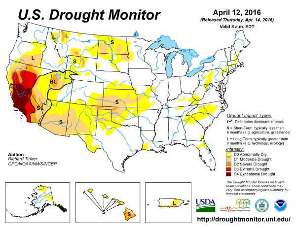
(Conditions
of extreme or exceptional drought still cover most of California.
With ground water greatly depleted, snow packs below average, and
reservoirs below average, a likely hotter than normal Summer followed
by a predicted La Nina will tend to worsen drought conditions for the
State and possibly for Arizona and New Mexico as well. A Strong El
Nino was the best chance for California to receive
drought-alleviating moisture. And it appears that opportunity has now
passed. Image source: Climate
Prediction Center.)
Despite
strong water conservation policies set in place by the State during
2014 and tightening through 2015, reservoir
levels are near normal in the North and well below normal in Central
and Southern regions.
Snowpack, which California relies on for water throughout the
summer, is
below average in all major regions, though rather higher than during
2014 and 2015.
Taking
these measures into account, it appears that California received
overall below average moisture amounts during the El Nino Winter of
2016 with
normal levels of moisture falling on the northern 2/3 of the state
and with the southern 1/3 receiving far less than normal
precipitation over the past 90 days.
As strong El Ninos typically bring above average amounts of
precipitation to California, 2016 levels falling below even an
average marker should be serious cause for concern.
Closer to
average, but still below average rains and snows, are nowhere near
enough to bust what has been the worst drought in state history. More
to the point, it appears that the current drought has settled in to a
semi-permanent state with no end in sight entering its fourth year.
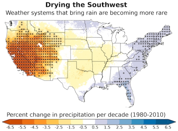
(The
continuation of the California drought and the failure of a strong El
Nino to deliver even normal levels of Winter moisture to the state
are a part of an ongoing, climate change induced trend of western
drying that has been growing in intensity since the 1980s. NCAR
earlier this year found that California was losing, on average, about
6.5 percent of its pre-1980 average precipitation per decade. Image
source: NCAR and Climate
Progress.)
National
Weather Forecasters at NOAA now
predict an increasing likelihood of La Nina coming later this year. A
moderately strong cool Kelvin Wave now rippling beneath the Pacific
is beginning to surface in the Equatorial waters just to the west of
Central and South America. If these cooler surface waters fan out
along the path of the trade winds as predicted, it will likely be yet
one more bit of bad news for California. La Nina, which
may be in full swing by this Fall,
tends to bring drier conditions to California. With the State’s
groundwater still greatly depleted, with snowpacks still well below
average, with reservoirs below average and with the State likely
to face a warmer than typical Summer,
this should be viewed by West Coast policy makers and residents alike
as ominous news.
These
are the kinds of conditions climate modelers predicted were a risk
for the US Southwest as a result of human-forced warming. A
climate state that researchers at NCAR earlier this year found was
already starting to settle in as weather systems bearing moisture to
the region were becoming more rare and infrequent due to a fossil
fuel forced heating of the globe.
Conditions
in Context — Severe Events Related to Human-Forced Warming Abound,
Much Hotter Than Normal Summer Likely on the Way
Based
on observations of overall trends, it appears that this Summer has
been prepped for some obnoxiously extreme conditions.
Never-before-seen Arctic Winter temperatures, record low sea ice,
persistent pooling of hot water at the surface in the Northeastern
Pacific, persistent development of strong ridges and record early
season heatwaves over Western North America, the blocking of El Nino
moisture from California by a northward shift of the storm track, the
appearance of odd convective weather patterns like thunderstorms in
the far north during April, and due to the fact that 2016 is shaping
up to be the hottest year on record by a long shot globally all
contribute to an overall pattern setting Western North America up for
another weird Summer of freakish weather.
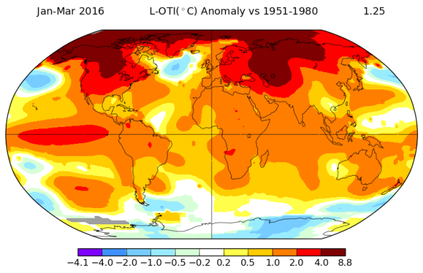
(We
have never seen Winter heat like this before over Western North
America. This set-up creates a dangerous preparation that results in
a heightened risk of seriously severe Summer extreme weather events
like heatwaves, droughts, wildfires and thunderstorms ranging well
into the far north. Note a similar preparation for Western Russia and
North-Central Siberia. Image source: NASA
GISS.)
Much
higher than normal temperatures predicted over the US West,
Northwest, Central, Northern and Western Canada, and Alaska are
likely to result in increased risk of wildfires, heatwaves, drought,
and related severities.
Thunderstorms ranging far into the north
where the permafrost thaw zones are now expanding bring together an
unprecedented combination of new fuels for fires and more intense
ignition sources in the form of Arctic thunderstorms.
Possible early
melt and low albedo related accumulation of abnormal warmth in the
Arctic could exaggerate these extremes even outside of the high
ranges which NOAA models are now predicting. And the pole-ward
progression of El Nino related heat in the shift toward La Nina
should propagate strongly along the now well-established pathway of
the Northeastern Pacific and the North American West.
Such
new weather and climate tendencies will almost certainly continue to
result in weather events that residents will find odd and freakish.
To this point, if you observe an extreme heatwave, instance of
wildfire, or other instance of extreme weather in your area over the
West this Summer it has almost certainly been given a serious amount
of added oomph by the expanding number of climate change related
conditions affecting your region.
Links:
Hat
Tip to Cate
Hat
Tip to DT Lange
Hat
Tip to Greg
Hat
Tip to Colorado Bob
Hat
Tip to Jean
No comments:
Post a Comment
Note: only a member of this blog may post a comment.