"Bomb Cyclone" Detonates
Over Alaska's Aleutian Islands
Unleashing Hurricane Force
Winds
Zero Hedge,
1 December, 2020
A monster storm explosively intensified in the northern Pacific near Alaska's Aleutian Islands on New Year's Eve, battering the region with hurricane-force winds, heavy seas, and torrential rains, according to Reuters.
"It's the most intense storm ever recorded in the North Pacific, excluding typhoons," said Brian Brettschneider, a National Oceanic and Atmospheric Administration (NOAA) scientist with the National Weather Service (NWS).
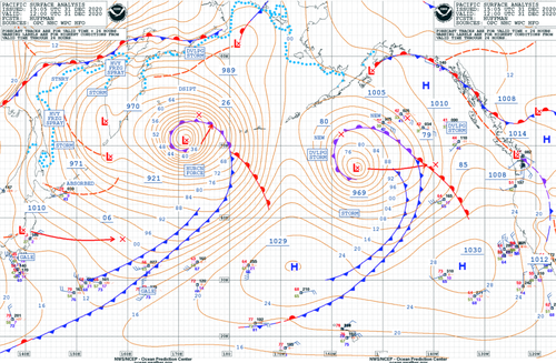
The storm is classified as a "bomb cyclone" after meteorologists recorded barometric pressure of 921 millibars, a record-low reading for the region, equivalent to the center of a Category 4 hurricane.
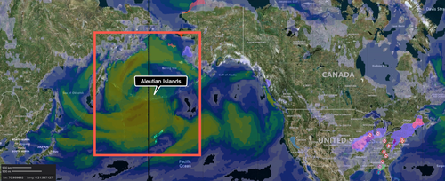
Wind Speed Map

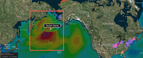
In western Aleutians, waves greater than 50 feet were seen with winds more than 80 mph, or on par with a Category 1 hurricane. The islands are barely populated, and the storm poses a limited risk to humans, but the area is a heavily used commercial shipping route between Asia and the US.
Wave Height Analysis

Brettscheneider said the real threat of the storm is aircraft or vessels in the region.
Unlike hurricanes, these large and powerful storms go unnamed," Capital Weather Gang's weather expert Jeff Halverson wrote back in 2015.
The National Weather Service's (NWS) Ocean Prediction Center (OPC) tweeted Thursday night:
"Here is the latest surface analysis showing a strong storm with winds to #hurricaneforce moving toward the Bering Sea. The central pressure is 921 MB making it one of the strongest storms to ever impact the North Pacific. Winds are expected to reach 95 kts near the low center!"

Satellite imagery of the storm is impressive.
Late last night, NWS-OPC tweeted:
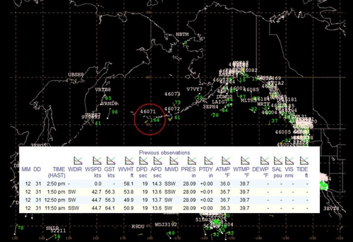
"The #HurricaneForce low near the Aleutians continues to produce extreme conditions. Buoy 46071 (circled in red) is observing seas greater than 50 ft. Note in the insert the 58 ft measurement."

The jet stream is likely to carry the weather disturbance into the Pacific Northwest next week.
COLD FRESHWATER LID ON NORTH ATLANTIC
Sam Carana, via Facebook
At least ten tipping points look set to hit the Arctic hard, as described in an earlier post. Tipping points are abrupt climate changes that typically occur as self-reinforcing feedback loops start to kick in. Such tipping points can coincide and they are in many ways interrelated, making that the danger is compounded by the domino effect of multiple tipping points hitting one another.
One feedback that is rarely-mentioned is the cold freshwater lid that is forming at the surface of the North Atlantic.
Temperatures in the Arctic are rising faster than elsewhere in the world. As a result, the temperature difference between the North Pole and the Equator narrows and this slows down the overall speed at which the jet stream circumnavigates Earth. It also widens the band within which the jet stream travels, so at times the jet stream will fan out widely or become much more wavy.
This distorted Jet Stream can cause more hot air to travel from the Atlantic Ocean and Pacific Ocean into the Arctic, as well as more cold air to travel out of the Arctic and descend over Europe, Asia and North America. Furthermore, high sea surface temperatures strengthen the wind over oceans, in turn increasing the speed of ocean currents and wave height.
One image (from an earlier post) shows the situation in September 6, 2020, when high sea surface temperatures on the Northern Hemisphere and a narrow difference between the Equator and the North Pole distorted the Jet Stream, making it cross the Arctic Ocean, form circular wind patterns and reach high speeds over the North Atlantic. The Gulf Stream off the North American coast reached speeds of 8 km/h or 5 mph.
Emissions by people heat up the air, which heats up oceans and makes winds stronger, in turn speeding up global ocean currents. A 2020 study by Hu et al. found increased kinetic energy in about 76% of the upper 2,000 meters of global oceans, as a result of intensification of surface winds since the 1990s. Wind speed increases especially during Winter on the Northern Hemisphere, when there are large temperature differences between the oceans and continents on the Northern Hemisphere.
Below follow a number of images showing wind speed at different pressure levels, i.e. 850 hPa and 250 hPa (Jet Stream), wave height, sea surface temperature anomalies and 3-hour precipitation accumulation, all on December 12, 2020.
One image shows that, on December 12, 2020, waves as high as 12.95 m or 42.5 ft (green circle) were recorded in the North Atlantic, and wind speed was 139 km/h or 86 mph (at 850 hPa) at that location.
The next image shows that, on December 12, 2020, sea surface temperatures were very high off the east coasts of Asia and North America, where ocean currents carry hot water to the north-east. As the image shows, the sea surface temperature was 14°C or 25.1°F higher than 1981-2011 at the green circle.
High sea surface temperatures are causing winds over oceans to get much stronger than they used to be at this time of year. The image below shows that, on December 12, 2020, the jet stream reached speeds as high as 406 km/h or 220 mph (at the green circle), while instantaneous wind power density at 250 hPa (jet stream) was 141.1 kW/m².
These strong winds then collide at high speed with the air in front that is moving at a slower speed. This collision occurs with an even greater force due to the lower overall speed at which the jet stream circumnavigates Earth, and especially in Winter on the Northern Hemisphere, when temperatures over land (i.e. North America, Europe and Asia) are low. Where such collisions occur, the air gets strongly pushed aside toward the Arctic and the Equator. The images show the Jet Stream criscrossing the Equator and moving high up in the Arctic.
Another image shows 3-hour precipitation accumulation as high as 94 mm or 3.7 in (at the green circle) on December 12, 2020.
At times, the Jet Stream can reach even higher speeds. The image on the right shows that on December 20, 2020, the Jet Stream reached a speed of 406 km/h or 252 mph at the green circle, while the Jet Stream crosses the Equator in the south and, in the north, wind forms a circular pattern over the Arctic Ocean. As described in an earlier post, the Jet Stream was as fast as 411 km/h or 255 mph south of Greenland (at the green circle), before crossing the Arctic Ocean on November 4, 2020.
As said, as ocean heat increases, the temperature difference between land and oceans increases in Winter on the Northern Hemisphere, when land is cold.
The temperature difference increases even more at times when cold air descends from the Arctic over North America and over Europe and Asia.
This larger temperature difference results in stronger winds that can carry more warm, moist air farther down the track of the Gulf Stream, as illustrated by image on the right that shows precipitation in mm per hour.
A warmer sea surface, in combination with distortions of the Jet Stream, can cause a sudden strengthening of the wind that can push warm, moist air all the way from the Atlantic Ocean into the Arctic.
As oceans heat up, more water evaporates from the sea surface. This evaporation will cool the sea surface somewhat, so the sea surface can be colder than the water just underneath the sea surface.
Much of the moisture that evaporates from the sea surface will get blown farther along the path of the Gulf Stream in the direction toward the Arctic before precipitating, thus contributing - along with meltwater - to the formation of a cold freshwater lid at the surface of the Atlantic Ocean.
Another image shows a wavy Jet Stream pushing precipitation north over the Atlantic Ocean, with 0.9 mm or 0.04 in of precipitration (3-hour accumulation) reaching the North Pole on December 24, 2020.
Stronger winds along the path of the Gulf Stream can speed up sea currents that travel underneath this cold freshwater lid over the North Atlantic. As a result, huge amounts of warm, salty water can travel from the AtlanticOcean toward the Arctic Ocean, pushing up temperatures and salinity levels at the bottom of the Arctic Ocean and threatening to destabilize methane hydrates that are contained in sediments at the seafloor of the Arctic Ocean.
Sea surface temperatures off the coast of North America were still very high on December 29, 2020, i.e. 14.1°C or 25.3°F higher than 1981-2011 at the green circle.
In summary, the danger is that stronger winds will trigger huge eruptions of methane, as more hot and salty water will reach the shallow parts of the Arctic Ocean that contain huge amounts of methane in the form of hydrates and free gas in sediments at the seafloor, resulting in huge eruptions of methane that, on its own, could almost instantly cause the 1200 ppm CO₂e cloud feedback tipping point to be crossed, which in turn can cause global temperatures to rise by 8°C.
From the page 'Cold freshwater lid on North Atlantic', at:


No comments:
Post a Comment
Note: only a member of this blog may post a comment.