

Damage
reported across northeastern Kansas following reports of massive
tornado
28 May, 2019
People Iowa through Oklahoma were faced with severe weather into Tuesday night as a round of powerful thunderstorms erupted over the central United States causing major damage.
Residents in Lawrence, Kansas are seeing major structural damage following a large tornado that hit the area on Tuesday evening.
One storm-related injury was reported in Claymont, Delaware where a tree fell onto a tent during a concert.
The Kansas City International Airport moved customers to a shelter due to a severe weather threat facing Kansas City, Kansas.
This follows the deadly tornado that hit Dayton, Ohio, on Monday night and the EF3 tornado that ripped through El Reno, Oklahoma, on Saturday night.
"The overall weather pattern that has been in place across the U.S. will continue early this week, which will bring more rounds of severe weather to the Plains," AccuWeather Meteorologist Brett Rathbun said.

Tornado damage from Tuesday evening in Morgantown, Pennsylvania.

Tornado damage from Tuesday evening in Morgantown, Pennsylvania.

Tornado damage from Tuesday evening in Morgantown, Pennsylvania.

Tornado damage from Tuesday evening in Morgantown, Pennsylvania.

Tornado damage from Tuesday evening in Morgantown, Pennsylvania.

Tornado damage from Tuesday evening in Morgantown, Pennsylvania.

Tornado damage from Tuesday evening in Morgantown, Pennsylvania.

Tornado damage from Tuesday evening in Morgantown, Pennsylvania.

Tornado damage from Tuesday evening in Morgantown, Pennsylvania.

(Twitter/Brooks_Barber)
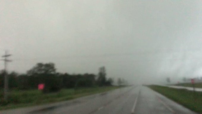
Severe storms moving through Gorham, Kansas.

(Twitter/Brooks_Barber)
Severe storms moving through Gorham, Kansas.

(Twitter/watersbc)
Damage at a rural cemetery in Wells County, Indiana.

(Twitter/watersbc)
Damage at a rural cemetery in Wells County, Indiana.

(AccuWeather/Kristina Pydynowski)
A severe storm developing near Bellefonte, Pennsylvania, on Tuesday afternoon.

(Twitter/Brooks_Barber)
Severe storms moving through Gorham, Kansas.

(Twitter/@meier_james)
Large hail that fell in Sandy Lake, Pennsylvania, early Tuesday afternoon.

(Kimberly Price)
Large hail in West Lawn, which is outside of Reading, Pennsylvania.

(Twitter/@5MDS003)
Golf ball-sized hail that fell during a tornado-warned thunderstorm in Selinsgrove, Pennsylvania.

Hail as large as golf balls fell in Kittanning, Pennsylvania.
(Twitter/@wolftrainer09)
Tuesday’s severe storms are forecast to focus on a zone from central Texas to southern Iowa. This includes St. Louis, Kansas City, Oklahoma City and some of the suburbs of Dallas.
"While large hail, damaging winds and flooding will be the main threats from these storms, the danger of tornadoes cannot be overstated," according to AccuWeather Meteorologist Brett Edwards.

The area at highest risk of more damaging storms and tornadoes will be northeastern Kansas and northern Missouri.
Meanwhile, severe storms are expected to track across the mid-Atlantic and could spin up some tornadoes across Pennsylvania into early Tuesday night.
RELATED:
At least 1 killed after large, destructive overnight tornado strikes Dayton, nearby Ohio communities
The difference between tornado watches and warnings
Tornadoes remain a danger as severe weather onslaught continues across central US
At least 1 killed after large, destructive overnight tornado strikes Dayton, nearby Ohio communities
The difference between tornado watches and warnings
Tornadoes remain a danger as severe weather onslaught continues across central US
The stormy pattern across the central U.S. will continue through Wednesday with another round of severe thunderstorms, including some of the same areas at risk of storms on Tuesday.
Download the free AccuWeather app and enabling audible alerts on your cell phone to receive severe weather bulletins when they are issued for your area, or watch the AccuWeather Network on DirecTV, Frontier and Verizon Fios.
10:30 p.m. CDT Tuesday:
Dozens of homes have been destroyed near Lawrence, Kansas, after a massive tornado tore through the area late Tuesday afternoon.
A chopper pilot estimated the width of the tornado to be around one mile.


SHOCKING. The damage in parts of Douglas County and Linwood can only be described as tragic. A large tornado ripped through the area, leaving in its path “dozens and dozens of destroyed homes.” bit.ly/2I0fVKH #kswx #kcwx

See KMBC's other Tweets


1,297 people are talking about this
9:30 p.m. CDT Tuesday:
A tornado has been confirmed near Morgantown, Pennsylvania, after the National Weather Service in Mount Holly, New Jersey, received video showing the tornado on the ground.
A storm survey team will assess the strength of the tornado on Wednesday.

At this time, we can confirm that a tornado did occur near Morgantown in Berks County PA based on video received showing a tornado on the ground. A final assessment including results of the survey are expected to be completed and transmitted via a PNS by Wednesday evening.
35 people are talking about this
9:15 p.m. CDT Tuesday:
A severe thunderstorm warning is now in effect for Pittsburgh, Pennsylvania, until 10:45 p.m. EDT Tuesday.

Severe Thunderstorm Warning including Pittsburgh PA, Monroeville PA, Plum PA until 10:45 PM EDT

See NWS Pittsburgh's other Tweets
9:00 p.m. CDT Tuesday:
The airfield at the Kansas City International Airport remains closed due to storm debris that was launched onto the airfield from nearby storms that produced the massive tornado in Lawrence, Kansas, earlier on Tuesday.

9pm update: Airfield is still closed because of storm debris that includes tree limbs & pieces of structures from elsewhere. Field Maintenance crews now onsite to clear. Optimistic reopening 10:30pm. Check FlyKCI.com or airline site.

150 people are talking about this
8:15 p.m. CDT Tuesday:
Major structural damage in Lawrence, Kansas following a large tornado that hit the area.


Tornado damage in Lawrence, KS: This was a two-story home where the Harrell family lived. They drove to a parking garage to seek shelter. When they returned this is what they found.
More on @kmbc

54 people are talking about this
8:11 p.m. CDT Tuesday:
Those in Excelsior Estates, a tornado is expected to arrive in about 10 minutes, according to NWS Kansas City.
Excelsior Springs Hospital is very close to, if not in, the path of this tornado. If you live on the north side of Excelsior Springs, take shelter now!
Those in Excelsior Estates, the tornado is expected to arrive in about 10 min! This is a dangerous situation! TAKE SHELTER NOW! #mowx

94 people are talking about this
8:00 p.m. CDT Tuesday:
There is a tornado warning in effect near New York City, New York including Staten Island, Newark, and Elizabeth, New Jersey until 9:30 p.m. EDT.

Tornado Warning including Staten Island NY, Newark NJ, Elizabeth NJ until 9:30 PM EDT

136 people are talking about this
7:30 p.m. CDT Tuesday:
There are damage reports of trees and highway signs down in Maywood, Kansas.
A house is reportedly "totaled" in Bradford County in Rome, Pennsylvania.
Storm-related injury reported in Claymont, Delaware where a tree fell onto a tent.
7:02 p.m. CDT Tuesday:
The Kansas City International Airport is moving customers to a shelter due to the severe weather threat in the area.
We are moving airport customers into the parking garage tunnels to shelter in place due to severe weather in the area. 7:02pm
279 people are talking about this
6:46 p.m. CDT Tuesday:
There is a Tornado Emergency including Kansas City, Shawnee, and Bonner Springs, Kansas. If you are near these areas seek shelter immediately!
AccuWeather Extreme Meteorologist Reed Timmer is reporting that a monster wedge tornado is approaching west side of Kansas City.
Monster wedge #tornado is approaching west side of Kansas City. Damaging massive tornado. Rocket sensor launched inside. Take cover in warned area this is real deal
@ChasinSpin is working to log live streamed data@accuweather @NWSTopeka

573 people are talking about this
6:30 p.m. CDT Tuesday:
Major damage has been reported in South Lawrence, Kansas. Lawrence Dispatch is being inundated with calls about emergencies.
The storm is now passing Lawrence. A role call on the radio verified all officers are accounted for. Officials urge residents to remain in their shelter until the warning has passed.
Dispatch is being inundated with calls. At this point calls are being evaluated to determine if they require officers or deputies to leave shelter to respond.

122 people are talking about this


6:20 p.m. CDT Tuesday:
A large, confirmed tornado is on the ground near Lone Star, approaching an area south of Lawrence, Kansas.
6:15 p.m. CDT Tuesday:
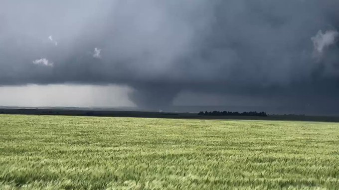
A violent and large tornado was reported north of Luray, Kansas, it has since dissipated.

Check out this shot of a large tornado near Luray in Russell County. Tornado WARNINGS continue in north-central Kansas. We're streaming now at kake.com/WeatherNOW?utm… #KAKEnews #kswx Courtesy Shawn Milrad (Embry Riddle Aeronautical University Daytona Beach Meteorology)

See KAKE News's other Tweets
5:30 p.m. CDT Tuesday:
A large tornado has been spotted near Waldo, Kansas.
Large tornado at 5:29 pm near Waldo, KS. @NWSWichita @NWSHastings @spann @wxbrad #KSwx #tornado

91 people are talking about this
5:15 p.m. CDT Tuesday:
There are reports of damage in the area of Clarks Summit, Pennsylvania.
A Particularly Dangerous Situation tornado warning is in effect for Scranton, Pennsylvania.


4:36 p.m. CDT Tuesday:
A funnel cloud has been reported near Valley View, Pennsylvania in Schuylkill County.
AccuWeather Extreme Meteorologist Reed Timmer is targeting a tornado warned storm just to the southwest of Reading, Kansas. The storm is heading toward Osage City, Kansas.

Targeting this tornado warned storm just to the southwest of Reading KS heading toward Osage City KS! Dominator 3 moving in for intercept @breakingweather @accuweather
49 people are talking about this
2:50 p.m. CDT Tuesday:
Golf ball-sized hail near Sandy Lake, Pennsylvania, as well as Kittanning, Pennsylvania.


2:30 p.m. CDT Tuesday:
Other roads and low-lying areas in central to southern Iowa may have standing water or water overflowing from creeks and small streams through tonight.

Water over the road just east of the Freedom rock on Highway 25. @WHOWeather @WHOhd @NWSDesMoines

See Roger Riley's other Tweets
1:55 p.m. CDT Tuesday:
A tornado watch has been issued for northeastern Kansas and northern Missouri, including Kansas City. The NWS notes that a couple of intense tornadoes and significant wind gusts over 80 mph will be possible in this area between now and 10 p.m. CDT.

No comments:
Post a Comment
Note: only a member of this blog may post a comment.