

A
landcane over Australia

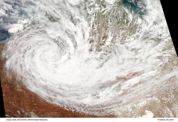
Satellite imagery on January 19, 2014. Image via Australia Bureau of Meteorology
Earthsky
,
25
January, 2015
Have
you ever seen a tropical cyclone – what most would call a hurricane
– develop over land? Is a landcane even possible? Although it
sounds strange and almost unlikely, in some cases it is possible for
an area of low pressure to obtain characteristics of a tropical
cyclone while over a land area. Last weekend – January 18-19, 2014
– an area of low pressure intensified across northwestern
Australia. Satellites indicated growing convection around the center
of low pressure and decent outflow around the entire system. Although
this system, this landcane, was not named, it is still a very cool
thing to see via satellite imagery.
What
causes these rare systems to form or intensify on land? As you will
find out, extreme weather can fuel these rare storms

How
did it form?
There
have been studies talking about the formation of “landcanes” over
Australia. In a paper
by Emanuel Et al (2008),
a group of scientists analyzed the redevelopment of warm-core
cyclones over northern Australia. In the paper, they suggest that one
of the reasons storms can intensify over land is thanks to large
vertical heat fluxes from a layer of very hot soil at the surface.
Usually,
when this occurs, the soil has been made wet by a recent storm
system. In a way, the wet ground acts like a shallow ocean that is
able to transfer energy to the storm. When this happens, a warm-core
cyclone can develop.
Typical
areas of low pressure are cold core systems, meaning there is cold
air at a high altitude within the system. A warm core cyclone are
what we see develop over open waters. Warm core low pressure systems
over open waters are called tropical cyclones.
Extreme
heat has hit Australia during the month of January. Temperatures have
soared above 38 degrees Celsius (100 degrees Fahrenheit). Over the
past several months, northwestern Australia has seen above average
rainfall. According to the Australian Government Bureau of
Meteorology, western Australia has seen nearly double the amount of
rainfall they typically average during the months of October,
November, and December.
Conditions
in Australia were ripe for a landcane to form.

Parts
of western Australia had seen nearly double the rainfall typically
seen during the months of October, November, and December 2013. The
wet ground probably helped steer the development of a landcane over
this region on January 18, 2014. Image via Australia Bureau of
Meteorology

WSR-88D
radar reflectivity image over Oklahoma at 1200 UTC 19 August 2007.
Graphic courtesy of the National Weather Service Forecast Office in
Norman, Oklahoma
In
another study by Theresa
Andersen and Dr. Marshall Shepherd from the University of Georgia,
research was done to understand how these systems can develop over
land. One of the many examples that were looked at was Tropical Storm
Erin (2007), which intensified over land while spinning over
Oklahoma. Erin formed an eye over Oklahoma which was seen through
radar imagery. The goal of this paper was to study why these systems
intensify over land. They framed the concept as the brown ocean. The
study was also the first comprehensive climatology of how frequently
this happens and the most likely geographic locations. Interestingly,
they found that Australia is the most likely place, particularly
after prior rainfall from other storm systems.
Andersen
and Shepherd show that a brown ocean environment consists of three
observable conditions. First, the lower level of the atmosphere
mimics a tropical atmosphere with minimal variation in temperature.
Second, soils in the vicinity of the storms need to contain ample
moisture. Finally, evaporation of the soil moisture releases latent
heat, which the team found must measure at least 70 watts averaged
per square meter. For comparison, the latent heat flux from the ocean
averages about 200 watts per square meter.

Bottom
line: Although it is rare to see tropical cyclones form over land, a
combination of wet soils and very warm temperatures contributed to
the intensification of an area of low pressure in Australia last
weekend. On January 18, 2014, a landcane formed over parts of
northwestern Australia.
No comments:
Post a Comment
Note: only a member of this blog may post a comment.