Bomb cyclone to bring damaging winds, downpours from UK to France and Germany at midweek
8 May, 2019
A bomb cyclone is set to bring damaging winds, heavy rainfall and localized severe thunderstorms to parts of western Europe into Wednesday night.
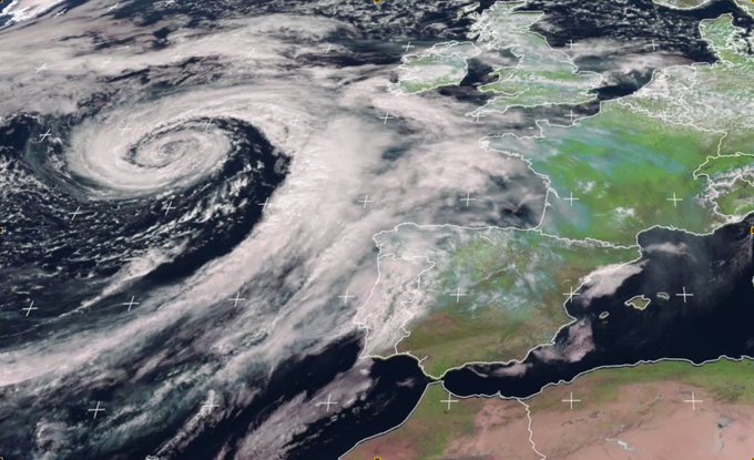
The rapidly strengthening storm underwent bombogenesis from Monday into Tuesday as the storm's central pressure rapidly fell over the open Atlantic Ocean between the Azores and western Europe.
Due to its rapid pressure fall, the storm achieved bomb cyclone status and will bring dangerous weather to parts of western Europe into Thursday.

Conditions across parts of the United Kingdom and France will deteriorate on Wednesday as the storm approaches, bringing increased rainfall and strong winds.
"Wind gusts to generally 65-80 km/h (40-50 mph) across central France into the Rhine River Valley and 80-95 km/h (50-60 mph) across the west-central region of France are expected," AccuWeather Meteorologist Tyler Roys said. "An AccuWeather Local StormMax™ of 120 km/h (75 mph) is possible along the central and southern coast of western France."
Areas near and to the south of Nantes will be at the greatest risk for these higher wind gusts, especially into Wednesday evening. The strong onshore wind and rough surf could lead to coastal flooding.
Nantes recorded wind gusts of around 60 km/h (37 mph) Wednesday afternoon.
The U.K. will dodge the worst of the storm's wind; however, frequent gusts of 35-50 km/h (20-30 mph) are expected throughout the country on Wednesday and Thursday.
"With leaves now on trees, branches may more easily break compared to a winter windstorm, leading to power cuts," Roys warned. Satellite imagery showed the intense storm swirling across the North Atlantic as it makes its approach.
RELATED:
Interactive France Radar
Detailed Paris Forecast
Woman freaks out after seeing towering tornado
Interactive France Radar
Detailed Paris Forecast
Woman freaks out after seeing towering tornado
While widespread damaging wind gusts are expected to be confined to western and central France, widespread rain will soak areas from the U.K. and western Germany into northern Spain and Portugal.
Downpours can lead to travel delays on roads with reduced visibility and the threat of hydroplaning. Commuters in cities such as London and Paris may need to allow for extra travel time. The evening commute in Frankfurt may face delays.
Thunderstorms will rumble across much of France on Wednesday and could become severe in some locations. "A tornado or two are possible in southwest France," said Roys.
During the afternoon, areas from Brest to Paris across northern France will be at their highest risk for thunderstorms. "Damaging winds, downpours and hail will be the biggest risks with these storms," added Roys.
Wind will lessen by Thursday with gusts over 65 km/h (40 mph) limited to eastern France and southern Germany.
Meanwhile, showers and thunderstorms will remain widespread across northern and central Europe. Residents from the British Isles and France to Germany may still need an umbrella, though some dry periods are likely as well.
A new storm will bring unsettled weather to the region from Friday into Saturday.


No comments:
Post a Comment
Note: only a member of this blog may post a comment.