

The Gulf Stream is heating up as the 2017 El Niño strengthens
The Gulf Stream is heating up as the 2017 El Niño strengthens, fueled by record low global sea ice extent, which means a lot of extra heat is getting absorbed globally.

Over
the next half year, increasingly warm waters will be carried by the
Gulf Stream from the coast of North America to the Arctic Ocean.
As
this warmer water arrives in the Arctic Ocean, there will no longer
be the buffer of sea ice there to consume the heat, as was common for
the past thousands of years and more. Additionally, warmer water
looks set to arrive in an Arctic Ocean heated up like we've never
seen before, as so much of the sunlight reaching the surface of the
Arctic Ocean doesn't get reflected back into space anymore.
Where
can all this extra heat go? Sea ice will start sealing off much of
the surface of the Arctic Ocean by the end of September 2017, making
it hard for more heat to enter the atmosphere. The extremely
dangerous situation is that it looks like much of the extra heat will
instead reach sediments at the seafloor of the Arctic Ocean that
contain huge amounts of methane in currently still frozen hydrates.


Arctic Sea ice is breaking up and flowing through Bering Strait

Arctic
Sea Ice 04 02 2017. While the "flock" has been squabbling,
Bering Sea ice has been breaking up and Arctic Sea ice is breaking
up. Arctic Sea ice is flowing through the Bering Strait, almost
unnoticed.
Here we go again - first state of emergency of new wildfire season

Within
five hours today, the area swept by the raging fires expanded by one
and a half times, reaching more than 2,000 hectares.
The
weather in the Siberian region is dry, warm and windy.
The
local Ministry of Natural Resources reported 20 epicentres of
wildfires.
323
firefighters were involved, and 66 units of equipmentdeployed to stop
the fires.
A
state of emergency was declared in Chitinsky and Khiloksky districts
of the region
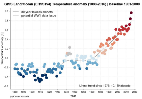
So Far, 2017 is in the Running to be the 4th Consecutive Hottest Year on Record
We
haven’t quite gotten to the global ‘year without a winter’ yet.
But it sure looks like we’re heading in that direction –fast.
Due
to the highest volume of heat-trapping
gasses hitting
the Earth’s atmosphere in all of the past 4-15 million years
combining with a warming of Pacific Ocean surface waters, the
period of 2014 through 2016 saw an unprecedented three consecutive
record hot years.
With Pacific Ocean waters cooling during late 2016, it appeared that
2017 would become ‘just’ the
2nd to 5th hottest year ever recorded. But that was before the waters
off South America’s west coast began to blaze with unexpected heat
during early 2017 even as temperatures at the poles climbed to
surprisingly warm levels.....
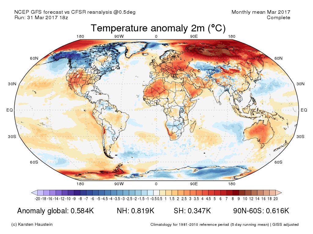
Looking
ahead, early indications are that March was also around 1.3 C hotter
than 1880s. If a first or second hottest March on record pans out as
indicated by early NCEP and GFS model reanalysis, then the first
three months of 2017 will come in nearly 0.1 C hotter than all of
last year.
Both, March GFS analysis & NCEP reanalysis 0.03K warmer than Feb. Corresponds to +1.07K in @NASAGISS Easily 2nd warmest March #climatechange


During
the present human-forced warming trend, it has tended to take about
ten years for a global temperature increase of 0.15 degrees Celsius
to occur. And that rate of warming is about 30 times faster than the
warming that occurred at the end of the last ice age. Since 2013, the
world has warmed 0.25 C — which could jump to 0.3 to 0.35 C in the
period of 2013 to 2017 if the present trend for this year continues.

Southeast
England, which includes the capital, had the warmest month since
records began in 1910, according to the U.K.’s Met Office. The
average temperature of 9.2 degrees Celsius (49 degrees Fahrenheit)
equaled a record set in 1957, the year the Soviet Union launched
Sputnik 1, the first human-made object in space. The U.K. overall had
its fifth-warmest March on record.
The
trend is supposed to continue into April across the whole of Europe,
according to meteorologists surveyed by Bloomberg. An early start to
summer could raise the risk of drought and further reduce heat and
power prices, which have plunged since February.
April
“is looking very dry across Iberia,” said Claire Kennedy-Edwards,
a senior meteorologist at Atlanta-based The Weather Co. “Very dry
springtime conditions over Iberia, resulting in soil moisture
deficits, can lead to a greater risk of heat wave events over
Europe.”
March
was 1.8 degrees Celsius (3.2 Fahrenheit) warmer than average,
according to the Met Office. It was also unusually bright, with 21
percent more hours of sunshine than usual. Precipitation was near
normal levels except in Wales, where 164.7 millimeters (6.5 inches)
of rain fell, 141 percent of the seasonal norm.
For Colombia, The Rain Bombs of Climate Change Fell in the Dark of Night
As
the lower atmosphere becomes warmer, evaporation rates will increase,
resulting in an increase in the amount of moisture circulating
throughout the troposphere (lower atmosphere). An observed
consequence of higher water vapor concentrations is the increased
frequency of intense precipitation events… — NASA’s Earth
Observatory
******
Just
off the coasts of Colombia, Ecuador and Peru, the Pacific Ocean has
been abnormally warm of-late. For the past month, sea
surface temperatures have ranged between 3 and 5 degrees Celsius
above average.
This excess heating of the ocean surface, facilitated by human-forced
climate change, has pumped a prodigious volume of moisture into the
atmosphere of this coastal region. Southerly winds running along the
western edge of South America have drawn this moisture north and
eastward — feeding into the prevailing storms that originate on the
Atlantic side of South America and track eastwards.
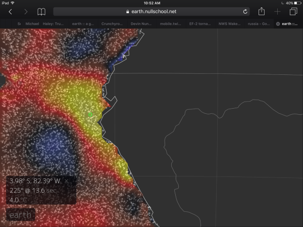
(Sea
surface temperature anomaly map from Earth Nullschool shows 4 degree
Celsius above average ocean surfaces just off-shore of Ecuadore and
Colombia. These extremely warm waters have helped to fuel very severe
storms over Peru and Colombia during recent weeks. Such warm ocean
waters are not normal and their highest peak temperatures are being
increased by a human-forced warming of the Earth, primarily through
fossil fuel burning. Image source: Earth
Nullschool.)
Lately,
these systems have blown up to enormous size as they’ve run across
the Andes or collided with pop-up storms along the coast. And the
amount of rainfall coming out of the resulting monster thunderstorms
has been devastating. In Peru, hundreds
of thousands of people have been rendered homeless by these
deluges which
have caused the tragic loss of 100 souls, destroyed thousands of
buildings, 200 bridges, and 2,000 miles of highway. For the state,
the estimated damage toll from this ongoing climate disaster is now 6
billion dollars.
Friday
night, a member of this new breed of monster thunderstorms, pumped to
greater intensity by the moisture bleed off the record warm ocean
waters, unloaded
a total of a half-month’s worth of rainfall in just a few hours
upon the small Colombian city of Mocoa.
More than five inches fell in 1-2 hours on a region where three
rivers run out of the mountains toward this community of 40,000. The
deluge arrived in the darkness. Its ferocious intensity unleashed a
massive flood of boulders, mud, and water as the combined rivers
leapt their banks and invaded the town. A nearby hillside, unable to
retain integrity beneath this merciless assault of the elements, gave
way — burying a large section of Macoa in rubble......
Himalayan Melt 1984 to 2016
To what extent are the fires in Siberia consuming newly released methane and how does that affect the methane in the upper atmosphere.
ReplyDelete