Sea Ice Testing New Record Lows as Heat Wave Invades Northwest Territories
12
May, 2015
For
2015, it looks as if Arctic sea ice is sitting in some rather hot
water.
For
from the Chukchi to the Beaufort to Hudson Bay to Baffin Bay and on
into the Kara, the edge region of the Arctic Ocean is feeling a very
strong melt pressure during early May of 2015. And, according to 7-10
day forecasts, that melt pressure will only intensify. As a result,
we could see new record lows for Arctic sea ice extent over the next
few days.
Early
Melt for the Chukchi and Beaufort
Arctic
warming is now particularly intense along a broad region running from
coastal Alaska through to the Mackenzie Delta and on into the
northwestern portion of the Canadian Archipelago. It’s an area that
typically waits until at least June to melt. But, this year, sea ice
recession, break-up and opening of large polynyas for this far
northern area is occurring almost in tandem with melt in more
southerly regions like Hudson Bay.
For
both the Chukchi and Beaufort Seas are continuing an early melt that
began in March and has proceeded on to this day.
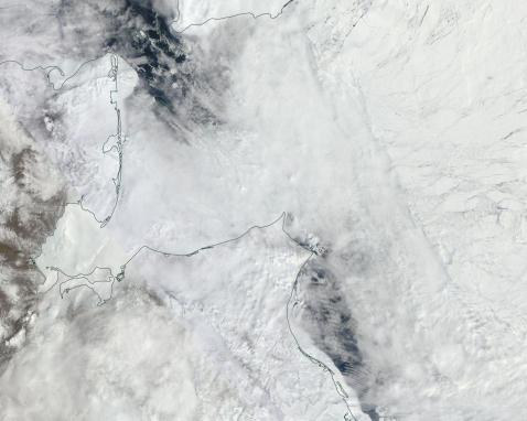
(Chukchi
Sea north of the Bering Strait showing early melt and break-up on May
11, 2015. Image source: LANCE-MODIS.)
In
the image above we can see the MODIS satellite shot for the Chukchi
Sea region on May 11, 2015. Note both the fractured nature of sea
ice, the ice edge retreat that has already progressed well past the
Bering Strait (a retreat far beyond a steadily retreating average
extent line), and the very large polynya advancing into the Chukchi
along the northern edge of Alaska.
It’s
a melt that has been spurred by powerful southerly air flows and
wind-driven currents issuing from the Bering Sea and Pacific Ocean to
the south. There, a cluster of storms continued to back up and
deflect northward toward the Arctic as powerful high pressure ridges
remained entrenched over a pool of record warm water in the
Northwestern Pacific.
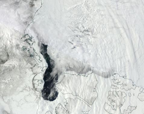
(Beaufort
Sea ice near Mackenzie Delta showing advanced signs of break-up on
May 11 of 2015. Image source: LANCE-MODIS.)
These
same ridges are driving warm air up over the western region of the
North American Continent. This flood of warm air has persistently
invaded the Northwest Territory of Canada, forcing an early melt of
the Mackenzie River. The heat has also frequently invaded the
southern Beaufort Sea. The result is that the sea ice there is
greatly fractured and that a large polynya dominates a wide area
bordering Alaska, the Mackenzie Delta, and the Canadian Archipelago.
This
polynya extends about 650 miles, has a width ranging from 15 to 80
miles and stretches 250 miles into the Canadian Archipelago between
the Northwest Territory mainland and Banks and Victoria Islands. Many
hundreds of miles to the north and east of this large polynya, is a
mess of fractured ice rippling out through the Beaufort Sea. A
massive disassociated ice flow that belies great general weakness for
sea ice in the region.
Risk
of Rapid Melt
As
melt season progresses, these wide, dark areas of open ocean will
serve to trap the radiant heat of 24 hour sunlight. The expansive
stretches will generate swells that tear away at the surrounding ice.
Already fractured ice flows will retain far less integrity than the
contiguous, and far thicker, ice of years past. These combined
factors set up conditions that can greatly enhance and speed the rate
of ice loss as the spring advances into summer.
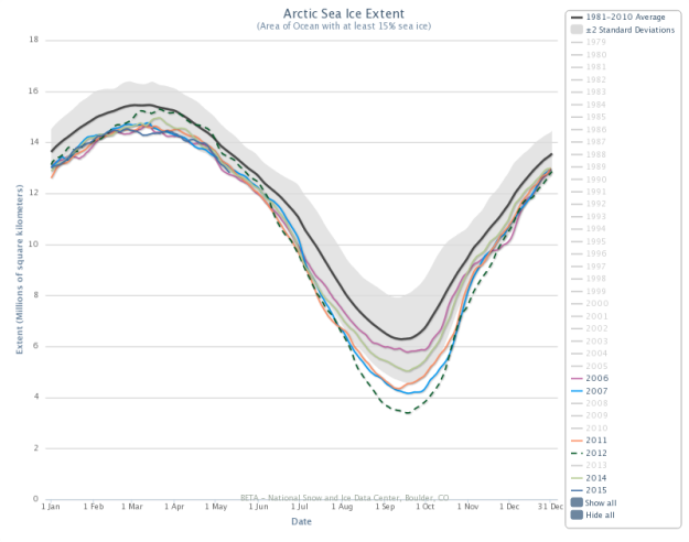
(NSIDC
shows sea ice extent at second lowest on record for May 11, 2015.
Rate of decline implies a plunge toward the 2006 record low line.
Image source: NSIDC.)
This
risk is particularly relevant when we consider that sea ice extent
measures were at record low values throughout about half of March and
for brief periods during early April. Currently, sea ice extent is at
its second lowest level on record. A value that is now rapidly
plunging toward the record low line set in 2006. Any
continuation of the current rate of decline would bring the extent
measure into new record low territory over the next few days.
A
weekly continuation of this trend could push extent values far into
record low territory, further worsening sea ice prospects for the
broader 2015 melt season.
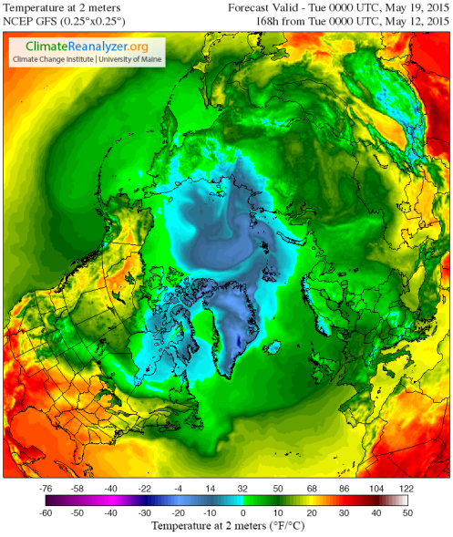
(7
day forecast shows Arctic heatwave building through the Northwest
Territory. Image source: Climate
Reanalyzer.)
To
this point, 7 day forecasts predict a massive warm-up building over
Alaska and the Northwest Territory through May 19th. Temperatures
over land in this area are expected to build into the 70s and low
80s. This extreme warmth, in the range of 10-20 Celsius above average
(18 to 36 Fahrenheit), will stretch all the way to Arctic Ocean
shores off the back of a ridiculously resilient ridge in the Jet
Stream. A ridge that has persisted, off and on, for much of the past
three years. Above freezing temps will pulse out from the ridge to
cover most of the Chukchi and almost all of the Beaufort — adding
melt pressure to already fragile sea ice conditions for that region.
Links:


No comments:
Post a Comment
Note: only a member of this blog may post a comment.