Arctic Sea Ice Conditions Worsen, Nightmare Melt Scenario in the Works?
22
May, 2015
It’s
the end of a bad week in a bad month in a bad season in the
all-too-bad, human-heated, era for Arctic sea ice. As of the middle
of this week, both the US measure — NSIDC — and Japan’s measure
— JAXA — were showing record low daily sea ice extents. The
lowest levels in the history of Arctic sea ice observation for this
time of year and likely the lowest levels for hundreds, even
thousands of years.
As
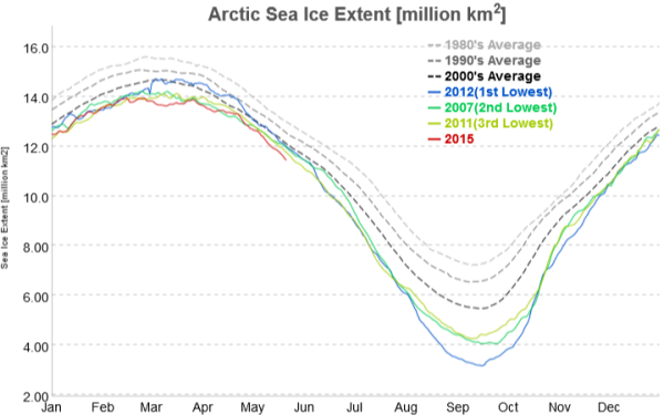
charts go, the JAXA graphic looks pretty amazingly ominous. A 2015
sea ice extent line diving below all others, steadily plumbing an
abyss that, if not this year or the next, could lead to a dreaded
blue ocean event in the not-too-distant future. The kind of upshot
from human greenhouse gas emissions we thought we might see by 2080
or later. One that has become increasingly more likely during recent
years and that some researchers are expecting could emerge by before
2020.
(JAXA
sea ice measure plunging to new record lows on May 22 and now hitting
a very steep angle of decline. Image source: JAXA
Polar Research.)
Above
you can seen the 2015 red line taking its most recent plunge after
hovering very near to record low levels. According to JAXA’s Polar
Research Center, sea ice extent dropped like a stone to 11.44 million
square kilometers yesterday, or about 200,000 square kilometers lower
than the previous record low value set in 2006.
Divergence
in May
The
problem is not just one of a new record low. It’s one of timing and
divergence. Accelerated melt in the May-to-June time-frame can have
serious impacts on late season ice. The reason is that greatly
reduced ice coverage also reduces albedo or reflectivity. The result
can be compounded warming and increased heat absorption by darker
surfaces under the 24 hour Arctic sunlight of June and July.
Large
open stretches of ocean also enable swell formation, which can chew
away the ice. And already we can see very large sections of dark, low
albedo, ocean forming throughout many vulnerable regions.
(MODIS
satellite shot shows widespread regions of open ocean and far
northward melt advance for this time of year. Image
source: LANCE-MODIS.)
For
this time of year, we have very advanced sea ice loss and open ocean
development in the regions of the Chukchi, the Beaufort, Northern
Baffin Bay and the Kara. In addition, large open water areas are now
becoming visible in the Laptev. A far northern extent of sea ice melt
for May in addition to typical seasonal losses coming from Hudson Bay
and southern Baffin Bay.
Such
record low ice totals at this time of year can enable far greater
melt advance by end season if the weather stacks up in all the wrong
ways. And, at least for the next week, the weather forecast is
tilting ever more heavily toward a melt-enhancing extreme warming of
Arctic regions.
Arctic
Warm Air Invasion Forecast to Continue
Over
the next seven days, heat is predicted to continue to flood from
south to north — goaded along by high amplitude ridges in the Jet
Stream continuing to form over Northwestern North America and the
Siberian region adjacent to the Kara Sea. The warm flux zones are
forecast to deliver unseasonable, above average temperatures to the
Arctic — resulting a general state of much warmer than normal
conditions for the entire Arctic Ocean by late next week.
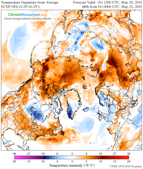
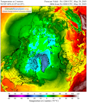
(Side-by-side
comparison of Arctic temperature anomaly forecast [left] and 2 meter
temperature forecast [right] for May 29, 2015 in the GFS model run as
provided and graphically displayed by Climate
Reanalyzer.
It’s worth noting that such extreme anomalies are very unusual for
Arctic Ocean regions during late spring and summer.)
As
a result, we see temperature anomalies for the entire Arctic Ocean
zone hitting a range of between 5 and 15 degrees Celsius above
average for next Friday (May 29, 2015). Such a warm air surge would
push temperatures in the above freezing range for almost the entire
Arctic Ocean area. These are temperatures more typical of late June
and early July. Conditions that, should they emerge, would result in
a multiplication of ice-threatening melt ponds, a further expansion
and warming of already unseasonably large open water zones, and a
forcing of more ice-eating, high heat content water vapor into the
Arctic environment.
Any
forecast is subject to uncertainty. Rapid May melt during 2013 and
2014 stalled out during June of those years. However, May melt is
significantly more advanced this year than during those years. And,
as opposed to 2013 and 2014, GFS model forecasts showing warmer than
normal conditions have tended to be correct. The warm air slots over
Northwest North American and Western Siberia are also very well
established at this time.
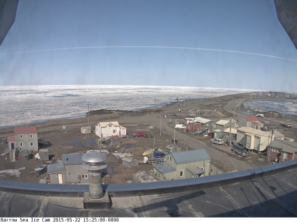
(Snow
cover gone, melt ponds plainly visible at Barrow Alaska today.
Proliferation of melt ponds during May and June can greatly enhance
risk of record low totals come August and September. Image
source: Barrow
Sea Ice Cam.)
As
a result, there’s high risk that the current record lows now
appearing in the NSIDC and JAXA measures with continue to deepen over
the coming week. It’s an utterly wretched situation for sea ice in
the Northern Hemisphere. One that will bear very close watching as
the risks now appear to be heading toward some unsettling markers.
Links:


https://www.facebook.com/notes/kevin-hester/shell-petroleum-admits-that-4-c-is-baked-in-short-term-6c-longterm-this-is-unsur/10205510353010898
ReplyDelete