

Tim
Bob: McPherson’s Paradox
Subscribe to

 Posts
All Comments
Posts
All Comments
Showing posts with label climate change.. Show all posts
Showing posts with label climate change.. Show all posts
Thursday, 9 August 2018


Tuesday, 24 July 2018
A record-breaking 41.1 C in Japan
Japan
heatwave: Temperature hits new historic record 41.1C, says Japanese
weather agency

22
July, 2018
Temperatures
in Japan have reached 41.1C, a new record for the country, amid a
deadly heatwave that has claimed dozens of lives.
The
temperature was recorded in the city of Kumagaya, a city northwest of
Tokyo, beating a previous high of 41C in the western prefecture of
Kochi in August 2013, according to the Japan Meteorological Agency.
Records
go back to varying dates for different cities, with data for Kumagaya
starting in 1896.
Authorities
are warning people to stay indoors and use air conditioning where
possible, with new deaths being reported almost every day for the
last week.
The
heatwave has set in not just over wide swaths of Japan, but also in
South Korea, where the country's highest-ever morning low was
recorded on Monday. The mercury sat at 31C at 6.45am in the city of
Gangneung, according to the Yonhap news agency.
Forecasters
said they expected highs on Monday of 39C in Nagoya and 37C in Tokyo.
Hundreds have been taken to hospital for treatment for heat stroke
symptoms, in addition to a death toll of at least two dozen.
Last
week, the heatwave had many residents in Tokyo questioning the wisdom
of staging the 2020 Olympics in July and August.
The
2020 Olympics will run from 24 July to 9 August, when temperatures in
central Tokyo can exceed 35C.
Tokyo's
Application File to host the 2020 Games reads: "The pleasant
weather conditions at this time of year will be ideal for athletes."
At
least 155 killed in Japan's worst weather disaster in 36 years
But
anyone who has spent a summer in Tokyo knows that is not necessarily
the case.
Experts
have warned the risk of heatstroke in Tokyo has escalated in recent
years, while noting the Olympics are expected to take place in
conditions when sports activities should normally be halted.
In
1964, the Olympics in Tokyo were held in October, mostly to avoid the
scorching heat, but that was before the Olympics became big business
and TV contracts determined schedules.
Organisers
are doing what they can but there is only so much that can be done to
beat the heat.
During
a visit to Tokyo last week, John Coates, the head of an International
Olympic Committee inspection team, acknowledged the heat will be a
huge challenge for organisers.
"We
are mindful that we do have to prepare for extreme heat," he
said at a news conference. "You're not the first country to host
the games in extreme heat. It's a natural consequence of being in
July and August."
Here are the statistics for the region

Scorched
Earth! European heat wave intensifies with hottest summer in nearly
50 years while Japan sets a new heat record of 41.1 deg C

Heat
wave in Europe, temperatures for Thursday 26th of July Credit
Earthwindmap
23
July, 2018
Temperatures
in Japan have reached 41.1C, a new record for the country, amid a
deadly heat wave that has claimed dozens of lives. The temperature
was recorded in the city of Kumagaya, a city northwest of Tokyo,
beating a previous high of 41C in the western prefecture of Kochi in
August 2013, according to the Japan Meteorological Agency.
Meanwhile,
Europe is expecting it's hottest week in many years as the heat wave
intensifies there.
In
many areas in Europe and the UK, no significant rain has fallen since
the beginning of May, while the Met Office has issued warnings for
people to stay out the sun this week as temperatures are expected to
rise to around 35 deg C (95 deg F).
Here
in Holland, the Dutch government have issued heat warnings for the
whole week as the mercury is set to rise well above 30 deg C, in my
own town of Alkmaar we have endured more than 60 days without rain.
The
heatwave in Sweden is getting so bad that the country has now sent
out official warnings about "extremely high temperatures"
in several areas, including Stockholm and Uppsala.
Sweden's
national weather agency SMHI on Sunday issued a class-two alert for
"extremely high temperatures" (the most serious temperature
warning) in counties in central parts of the country: Orebro,
Västmanland, Sodermanland, Uppsala and Stockholm.
The
warning means that temperatures are expected to reach 30C or more
five days in a row.
Wildfires
Trigger Evacuations Near Athens
Greece
is seeking assistance from the EU to battle forest fires that have
destroyed homes and forced thousands to flee on the outskirts of
Athens. At least six people have been injured. (July 23)
Saturday, 25 November 2017
Temperature records drop DESPITE cooler, la-Nina conditions
There is no doubt that a la-Nina is upon us in the Pacific.
The effects vary but in this part of the world (Australia and New Zealand) la-Nina normally brings cooler and wetter conditions.
This is what the following article portrays.
However, looking at conditions at the end of spring you’d hardly know it.
Cromwell in southern NZ saw its hottest temperature ever at 33.3 deg. C while the painter working next door here in Lower Hutt had to go home with heat exhaustion at the end of spring. He said that in 40 years of working as a painter he had NEVER seen such condition at the end of November.
He described the conditions as ‘dangerous’.
This was reiterated to me by a taxi driver.
Meanwhile Victoria, Australia is seeing unprecedented heat for this time of the year and anecdotal reports are telling me that conditions are far warmer than usual for late-fall in North America.
Today’s article from Sam Carana clearly shows that global warming is accelerating.
As
a heatwave hits Hobart and Adelaide The Bureau of Meteorology predict
a 'rare' form of the La Nina will bring a wet and cool summer in
Australia

Wikipedia
24
November, 2017
A heatwave may be enveloping southern Australia wrapping Melbourne, Hobart and Adelaide in unseasonable warmth, but don't get too used to it - we could be in for a wet and cool summer.
The Bureau of Meteorology (BoM) has upped its prediction of a 'rare' form of the La Nina climate driver and has said the event is now almost certain to develop, with the effects of the weather event possible as soon as next month.
In a climate note, the weather agency officially moved Australia to La Nina "alert" as it confirmed sea temperatures in the equatorial Pacific Ocean continued to cool, a key indicator it could be on its way.
La Nina and its more well-known brother El Nino are the two ends of what's known as the El Nino Southern Oscillation or ENSO.
This climatic cycle can have an impact on temperatures and rainfall in eastern and Northern Australia, as well as more extreme weather such as cyclones and droughts.
"Oceanic indicators of ENSO show a clear progression towards La Nina.
Tropical Pacific sea surface temperatures have cooled since late winter, and waters beneath the surface remain cooler than average in the eastern Pacific.
However, they are currently just shy of La Nina thresholds," the Bureau said on Tuesday.
"As a result, the ENSO Outlook has been raised to La Nina 'alert' meaning there is approximately a 70 percent chance - or triple the normal likelihood - of La Nina occurring."
To back up its climate call, the Bureau released a graph that showed all eight of its meteorological models pointed to equatorial sea surface temperatures dropping to -0.8C below the average 1961 to 1991 levels - the Australian threshold for a La Nina.
Seven of the eight models show a likely La Nina event, this is when sea temperatures remain across the threshold for at least three months.
Australia could move into La Nina in December and stay there all summer until February.
During a La Nina, while equatorial seas get cooler, the waters north of Australia warm up.
That helps to produce rising air, clouds and rainfall over, particularly, Northern Australia but also in eastern and central parts.
The chances of tropical cyclones and flooding can increase.
Daytime temperatures can also drop during a La Nina.
Conversely, longer duration, but less intense, heatwaves can be a feature.
However, weather boffins are being circumspect about just how much of an effect an upcoming La Nina will have.
If a La Nina is on the horizon, it usually makes its presence felt in Autumn or Winter.
The BoM said the "rare" nature of a La Nina occurring in Summer meant its impact was hard to judge.
"Climate models suggest that any [La Nina] event is likely to be weak and short-livd.
This means it is expected to be very different to the strong 2010-12 La Nina," the Bureau said.
Sea temperatures around the country's north were not expected to warm significantly, it continued.
At this point, the long-range weather outlook for Summer still suggests no strong push to either wetter or drier conditions.
Indeed, the Bushfire and Natural Hazards Cooperative Research Centre (BNHCRC) has cautioned the increased likelihood of a La Nina does not mean fire hazards are lessened.
In it's Southern Australia Seasonal Bushfire Outlook for Summer, released on Wednesday, the organisation said competing climate drivers from the Indian Ocean could pacify the extremes of La Nina.
Dr Richard Thornton, CEO of the BNHCRC, said preparations still needed to be made for the fire season.
"It is really important that people do not become complacent - despite being on La Nina alert, southern Australia will have a fire season, and we are in it right now," he said.
Temperature anomaly 11-24-2017+4.27 C across the Arctic

Australia Heatwave Threatens Blackouts may Shatter 130yrs Record
Australia Record Heat 2017 http://www.climatesignals.org/headlines/events/australia-record-heat-2017
Heatwave health alert issued for southern Tasmania as 130yo record set to fall. http://www.abc.net.au/news/2017-11-21/weather-health-warning-for-southern-tasmania/9174300
Power plant failures push Victoria’s energy grid close to the edge in November heat
Cromwell hits hottest spring temperature on record: RNZ Checkpoint
NZ: Have your sunscreen handy because summer's set to swelter, with higher than normal temperatures expected
Elsewhere, in the United States
Salt Lake City ties a 117 year heat record for Thanksgiving with temperatures reaching a balmy 68 degrees F (20 deg F)

Salt
Lake City has tied the heat record for Thanksgiving as the unusually
warm holiday week continues.
The
National Weather Service said Thursday that the high of 65 degrees
matches the record set on Thanksgiving 1910.
That
marks two consecutive record-setting days.
On
Wednesday, the high of 68 degrees broke a record for that date set in
1926.
The
National Weather Service said it is expected to stay relatively warm
through the weekend with temperatures expected to be 15-20 degrees
above normal throughout the state.
Utah
also experienced record-setting heat this summer.
Thanksgiving warm records tumble as San Diego see's temperature soaring 93 deg F, (34 deg C)
Monday, 25 September 2017
Extreme weather report - Hurricane Maria
Climate
& Extreme Weather News #69 (September 17th-24th 2017)
Tuesday, 5 September 2017
NZ has its 3rd warmest August on record
Whatever you do DON'T MENTION THE ELEPHANT IN THE ROOM!
One degree of warming brings a 8 % increase in precipitation
NZ: Third hottest August on record hits during a season with a third extra rainfall
5
September, 2017
Winter
was a real mixed bag this year, with almost a third more
rainfall than normal, and the third hottest August on record.
Wellingtonians
can be forgiven for thinking their winter was particularly
trying, as the capital was the wettest and least sunny of the six
main centres in Niwa's winter climate summary.
An
estimated 1000 slips played havoc with city roads and left
a number of capital residences evacuated, with four homes had their
foundations compromised.

GEORGE
HEARD/STUFF
Taieri
farmer Ross Farquhar had water surrounding his whole property after
a state of emergency was declared in Otago this year.
The
South Island was hammered by flooding on the weekend of July 21
and hundreds of homes were evacuated as the state of emergency
was rolled out in Waitaki, Dunedin, Christchurch, Selwyn, Timaru, and
then the entire Otago region.
READ
MORE:
* Winter of 1000 slips
* Explainer: How did Wellington's Ngauranga Gorge slip which closed SH1 happen?
* Is the capital crumbling?
* Winter of 1000 slips
* Explainer: How did Wellington's Ngauranga Gorge slip which closed SH1 happen?
* Is the capital crumbling?
Mid-July
was memorable for strong winds in the lower North Island, which
left more than 9000 people without power, and many flights at
Wellington Airport cancelled.

ROBERT
KITCHIN/STUFF
Ngaio
Gorge Rd in Wellington was closed a number of times this winter due
to slips.
On July 6 in Auckland, many flights put on hold or diverted as lightning and torrential rain passed over the airport, and on June 14 a total of 60 regional flights were cancelled and 48 delayed by fog.
Although
high, rainfall was extremely varied, with record low levels for
June in many locations.
Tauranga
was the most variable, and earned the sunniest award for the six main
regions, despite being sent into a state of emergency on July 21
and 22 due to heavy rain.

MARY-JO
TOHILL/FAIRFAX NZ
A
sandbagging crew desperately trying to save Kaitangata from severe
flooding with the Clutha Rivet dangerously high nearby.
Tekapo
took out the lowest temperature, with a frosty -14.6C on July
29.
Oamaru
took out the highest one-day rainfall, with 161mm on July 21
– more than the area would usually receive during the whole
winter season.
All
six main centres had above average temperatures, with Auckland
leading the charge with temperatures 0.8C above average.

GLENN
MCCONNELL/STUFF
The
Auckland Skytower took several hits of lightning during a
particularly savage storm this winter.
This
winter was the 11th warmest on record for New Zealand.
SIX
MAIN CENTRES
Auckland:
warmest
Dunedin:
driest
Tauranga:
sunniest
Christchurch: coolest
Wellington:
wettest and least sunny
Monday, 19 June 2017
Tsunami in Greenland!!
I hardly need to point out what this means.
Earthquake
& tsunami cause major flooding in Greenland
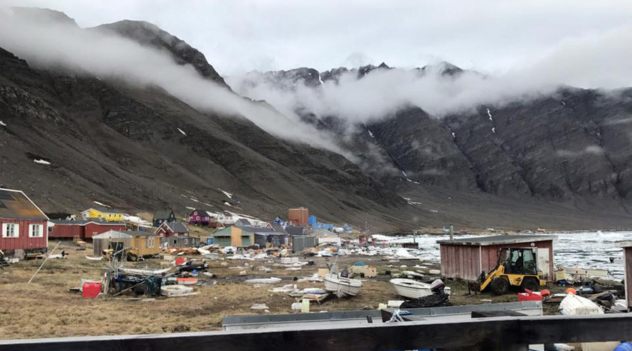
RT,
18
June, 2017
The
western coast of Greenland has been struck with a 4.0 magnitude
earthquake, triggering a tsunami that swept away several houses in
coastal villages. At least four people are feared missing, as a
rescue mission in the village hardest hit by waves is under way,
local police reports.
The
settlement of Nuugaatsiaq suffered the most, with 11 houses being
washed away and the community being left with no electricity. With a
registered population of 101, 78 people have been evacuated to the
town of Uummannaq, the Greenlandic Broadcasting Corporation
(KNR) reported,
citing police officials.
Two
people sustained serious injuries, and seven others less serious
injuries, police said. The remaining 23 people may be on vacation, or
have gone fishing or hunting, police chief Bjørn Tegner Bay said,
adding he couldn’t confirm whether there have been any fatalities
Police
urged the citizens of Illorsuit, which also saw the large waves, to
return to their homes, but warned of sirens that would signal people
to seek higher ground in case of aftershocks.
#Tsunami, #earthquake hit early June 19 on #Greenland's NW coast near Uummannaq. More details on our Facebook page. (PHOTO/@sermitsiaqag)


“It’s
not normal that we have such large quakes in Greenland,” said Trine
Dahl Jensen, a senior researcher at the Geological Survey of Denmark
and Greenland (GEUS), as quoted by Aftenposten.
Danish
Prime Minister Lars Lokke Rasmussen offered his sympathies to his
Greenlandic counterpart, Kim Kielsen, over what he called “a
terrible natural disaster” in his Twitter account.
With
a population of some 56,000 people, Greenland, the world’s largest
island, has a vast ice sheet which covers around 80 percent of its
area and is particularly affected by climate change.
Tsunami waves damage some villages on the Greenland coast - 4 people missing, 9 injured (2 serious)
Last
update: June 18, 2017 at 1:54 pm by By Armand
Vervaeck
This
damage was detected by our colleagues of the 2017 Earthquake Impact
Database - EID
on Google Docs - Like
EID on Facebook
Message
to people from Greenland : We
have noticed that Greenlanders are reading this article too. We have
opened the comment section below to give you the possibility to share
your experience or those from family members who experienced the
tsunami + eventual additional information you may have heard on the
Greenland TV and radio. We would really appreciate you comment. Thank
you
Update
12:40 UTC:
78 people have been evacuated from the village of Nuugaatsiaq
The Danish authorities did report that 4 people are still missing and that 2 people were seriously injured. 7 others sustained slight injuries.
11 houses haven swept in the water and are gone.
At the moment of the tsunami 101 people lived in Nuugaatsiaq. 23 people are still in the village, the rest has been evacuated to Uummannaq.
Although
we have no registered earthquake in the area, the Danish
seismological service GEUS has confirmed to the Danish press that a
M4.0 earthquake occurred in Greenland. Several villages have been
inundated by the water. One of them the village of Nuugaatsiaq (see
picture) 30 km south of the epicenter of the M4 earthquake.
The
Danish police gives only limited information as they are trying to
find out what exactly happened and how many villages sustained
damage.
Shortly after the news reached Denmark, the authorities have requested the population to go for higher ground.
Greenland
had similar tsunamis in the past. They were often caused by land- or
seaslides.
Except
for the material damage, there is no news of injuries or fatalities
but nothing can be excluded at the moment.
The
Greenland coast is sparsely populated.

Update
13:11 UTC:
The video below shows another wave of water swelling into the
village. Although the video does not give additional details, we
believe that this swelling is not the destructive tsunami. the
hurling sounds of animals is from the huskies who are used by the
Greenlanders for hunting. As per my earlier visit to Ittoqotoormit,
Greenland i remember that these huskies are fixed to anchors, so it
would not surprise me that some dogs may have been killed by the
water too.
The
Google Earth map below shows the steep cliffs in the surrounding
sounds. Additionally the village of Nuugaatsiaq is located on a
plateau with steep cliffs in the background.

Update
09:56 UTC:
The population of the village of Nuugaatsiaq (2010 census 84
inhabitants) have now all been evacuated to the town of Uummannaq
(1200 inhabitants) as the authorities do fear for aftershocks who can
generate additional land- or seaslides.
Update
09:58 UTC:
The probable epicenter location of the earthquake in on the below
photo (we projected 30 km North of Nuugaatsiaq on the map). The
Danish seismological service GEUS had the data but is probably NOT
working on a Sunday as we cannot gather more precise information or
news in their website!

Subscribe to:
Posts (Atom)