Showing posts with label tsunami. Show all posts

Friday, 8 March 2019

Ken Ring predicts major quake for New Zealand


New Zealand mathematician, Ken Ring predicts major quake on March 20


MaryGreeley News,

6 March, 2019


In a new report prepared for Prime Minister Putin by the Institute of Physics of the Earth warned that America in the next two weeks is in danger of catastrophic proportions Earthquake.


Focusing on the U.S., Mexico, Central and South America, and the region along the west coast of the New Madrid zone Fault.


SCIENTISTS have urged government officials to prepare for a terrifying and unprecedented magnitude-9 mega-earthquake that would unleash a deadly tsunami with 30 metre-high waves.


It is important to note that Russian and British scientists are leaders in predicting earthquakes based on these subtle electromagnetic signals and have joined forces to launch a satellite into space, to better track them.---


…..More ominously, the report is that Russian scientists have confirmed the independent analysis of New Zealand mathematician and long-term weather trends forecaster Ken Ring, who predicted the deadly earthquake in Christchurch (N. Zealand), and this week issued a new warning that the new earthquake should strike around 20 March.

Scientists have declared that it is a matter of “when, not if” a devastating earthquake strikes New Zealand, unleashing a mega-tsunami that could wreak havoc across large parts of the world. Geologists in New Zealand claim the Hikurangi Subduction Zone is one of the world’s biggest faultlines and there is evidence that it could soon set off a quake and a subsequent tsunami. The rupture of the fault line would cause damage and destruction on a scale bigger than the Japanese quake and tsunami of 2011.

Ring explains his methodology for predicting earthquakes in the following way:

“Planets strong influence on the Earth, but indirectly, by influencing the Sun. Some planets are very large. If the sun were basketball, the gas giants Jupiter and Saturn would be the size of a grapefruit, and the Earth on such a scale would be the size of a grain of pepper.

Jupiter and Saturn cause extra tides on the Sun (as in the case of the Earth and the Moon). These large solar tides become solar activity and solar flares.

At the moment, Jupiter and Saturn are on opposite sides of the Sun, and create time tug of war with Earth in the center. It began in September of last year, and will continue until about May.
In September, the Earth was in line with the Sun, Jupiter and Saturn.

That’s why in different places earthquakes above seven points. For example, in Pakistan, there was an earthquake at the same time with the earthquake in Christchurch. This alignment of Jupiter Saturn will continue until about May, and the Earth will be back on line in March. That is why around 20 March to expect accidents, large earthquakes may, when the Moon may be again in the position of the trigger element. “


Sunday, 23 December 2018

Tsunami in Indonesia DESPITE NO QUAKE!


Deadly tsunami hits Indonesia, despite no quake
23 December, 2018


At least 20 people have been killed after a tsunami struck Indonesia, despite no quake being recorded.
The waves hit beaches around Sunda Strait on Saturday night (local time, Sunday morning NZ time), according to the Indonesian Disaster Mitigation Agency.
At least 165 have been injured.
The Indonesian Meteorology, Climatology, and Geophysical Agency said it may have been the result of volcanic activity at Krakatoa.
Sunda Strait lies between Java and Sumatra, connecting the Java Sea and Indian Ocean.
When Krakatoa erupted in 1883, more than 36,000 people died and world temperatures were cooler for the next year.

20 dead as tsunami hits Indonesia beaches – government agency


RT,
23 December, 2018


At least 20 people have been killed as a tidal wave hit beaches around Sunda Strait in Indonesia on Saturday night, according to the country's Disaster Mitigation Agency. Another 165 have been injured.
The Indonesian Meteorology, Climatology, and Geophysical Agency (BMKG) said the wave was not caused by an earthquake, but was possibly the result of volcanic activity at Mount Krakatoa.

Video filmed at one of the affected beaches and posted on Twitter shows the wave rolling in as beachgoers scramble away from the water.


Images from the other side of the Sunda Strait showed the aftermath of the wave.


Embedded video

Data sementara dampak tsunami di Pantai di Kab Pandeglang, Serang dan Lampung Selatan hingga 23/12/2018 pukul 04.30 WIB: tercatat 20 orang meninggal dunia, 165 orang luka-luka, 2 orang hilang dan puluhan bangunan rusak. Data korban kemungkinan masih akan terus bertambah.

Sunda Strait separates the islands of Java and Sumatra. Its coast is located about 100km (62 miles) from the Indonesian capital, Jakarta.
MORE DETAILS TO FOLLOW
Krakatoa eruption lithograph.jpg


Refresh this list
SRCLocationUTC Date/timeMDINFO
ERI Felt A (not Listed) EarthquakeDec 22 23:594.60MAP I Felt It


  • Candler, NC - I was laying in bed reading and the bed shook a little for 10 seconds. The tv on our dresser also shook.
  • Harare - ~2 minutes
  • Harare - Light shaking
  • Harare - lasted 1 minute
  • Harare - I was laying on the bed and felt a slight movement of the bed.
  • Chiredzi - Quite a long earthquake.. lasted about 3minutes, ground was vibrating and sounded like my windows were about to shatter. The whole house was shaking.. worst earthquake I’ve ever experienced.
  • The Grange - Was in bed and felt mild rocking of the bed. Checked swimming pool and saw a gentle wavy pattern forming. Must have been around 0739hrs (Harare) and lasted less than 30 seconds
  • Harare - Windows and doors were rattling. It lasted about 15 seconds. No visible property damage.
  • Kathmandu - 500
  • USGSTiku, IndonesiaDec 22 21:464.961MAP
    GEOFONSouthern Sumatra, IndonesiaDec 22 21:464.869MAP
    EMSCSouthern Sumatra, IndonesiaDec 22 21:464.825MAP I Felt It INFO
    GEOFONChile-bolivia Border RegionDec 22 14:284.6122MAP I Felt It INFO
    USGSSola, VanuatuDec 22 14:256.042MAP
    GEOFONVanuatu IslandsDec 22 14:246.051MAP I Felt It INFO
    GEOFONDominican Republic RegionDec 22 14:124.6122MAP I Felt It INFO
    EMSCDominican RepublicDec 22 14:124.7120MAP
    EMSCKomandorskiye Ostrova RegionDec 22 13:345.210MAP
    GEOFONKomandorskiye Ostrova RegionDec 22 13:344.6369MAP
    USGSNikol'skoye, RussiaDec 22 13:345.210MAP
    GEOFONKomandorskiye Ostrova RegionDec 22 13:295.510MAP I Felt It INFO
    USGSNikol'skoye, RussiaDec 22 13:295.510MAP
    USGSChagos Archipelago RegionDec 22 08:034.910MAP I Felt It INFO
    GEOFONChagos Archipelago RegionDec 22 08:034.610MAP I Felt It INFO
    USGSAwaran, PakistanDec 22 07:444.610MAP
    EMSCPakistanDec 22 07:444.62MAP I Felt It INFO
    USGSTaron, Papua New GuineaDec 22 07:364.710MAP I Felt It INFO
    USGSBitung, IndonesiaDec 22 06:074.666MAP
    GEOFONNorthern Molucca SeaDec 22 06:074.648MAP
    EMSCKepulauan Talaud, IndonesiaDec 22 06:074.667MAP I Felt It INFO
    USGSChipinge, ZimbabweDec 22 05:375.57MAP
    GEOFONZimbabweDec 22 05:375.610MAP I Felt It INFO


  • Harare - Light shaking
  • Mutare - The whole bed, dressing table an vehicle outside were shaking quite strongly, for about 30 seconds.. No damage done.
  • Harare - Lasted about 5 seconds,no damage to property.
  • GEOFONNear Coast Of NicaraguaDec 22 05:174.724MAP
    USGSNear The Coast Of NicaraguaDec 22 05:174.810MAP I Felt It INFO
    EMSCTajikistanDec 22 00:324.940MAP I Felt It INFO

    Wednesday, 3 October 2018

    Volcanic eruption on Sulawesi where the qauke and tsunami hit


    Volcano erupts on same Indonesian island as earlier quake


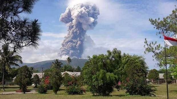
    A volcano has erupted in central Indonesia and authorities have warned planes about volcanic ash in the air. Photo / BNPB


    3 October, 2018

    A volcano has erupted in central Indonesia and authorities have warned planes about volcanic ash in the air.

    Mount Soputan in North Sulawesi province spewed ash 6,000 meters into the sky Wednesday morning (local time). No evacuations were immediately ordered.
    A government volcanologist suspects the eruption was triggered by the 7.5 magnitude earthquake in Central Sulawesi.
    "It could be that this earthquake triggered the eruption, but the direct correlation has yet to be seen as there had been an increase in the Mount Soputan activity," the volcanologist, Kasbani, told online news portal Tempo.
    Kasbani, who uses one name and leads the Vulcanology and Geology Disaster Mitigation agency, said volcanic activity had been increasing at Soputan since August and began surging Monday. "It is possible that the quake accelerates (the eruption)," he added.
    Soputan's eruption status was raised from an alert to standby 4 kilometers (2.5 miles) from the summit and up to 6.5 kilometers to the west-southwest. Standby status means the public should avoid the area nearest the volcano and have masks available in the event of ashfall.
    Planes were warned of the ash clouds because volcanic ash is hazardous for plane engines, howvever, disaster agency BNPD says it will not impact flights at this stage.
    Sam Ratulangi International Airport, located southeast of the volcano, will operate as usual for now.
    Face masks to help residents deal with the ash have been issued to the community.
    "The community does not need to evacuate because they are still safe," the latest alert reads.
    "Within a 4km radius there is no settlement. So it's still safe."
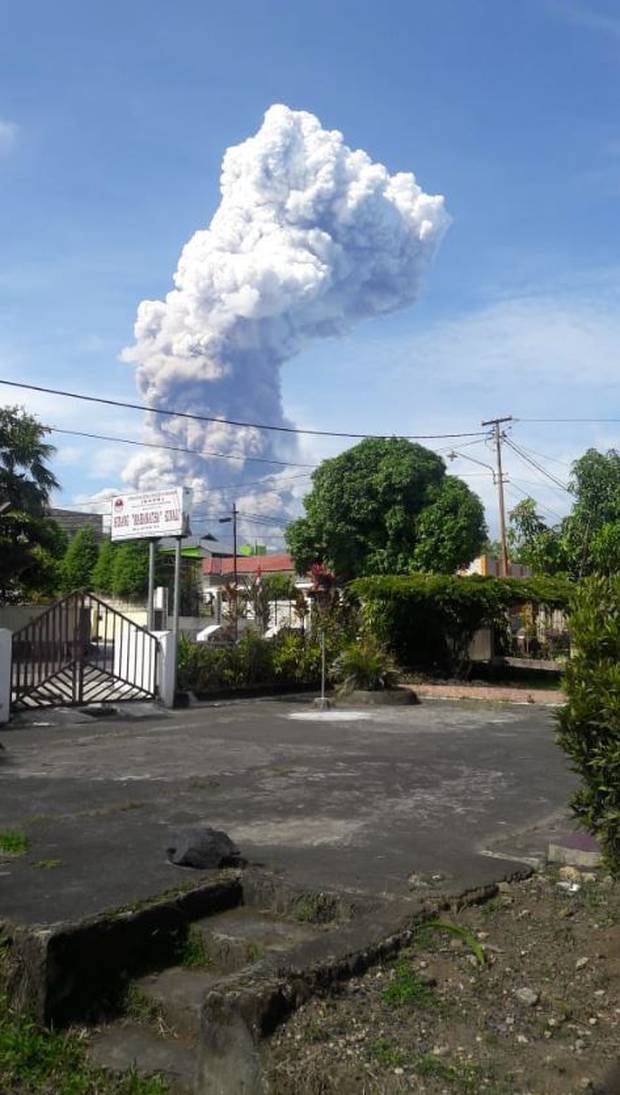
    Planes were warned of the ash clouds because volcanic ash is hazardous for plane engines, howvever, disaster agency BNPD says it will not impact flights at this stage. Photo / BNPB  
    Planes were warned of the ash clouds because volcanic ash is hazardous for plane engines, howvever, disaster agency BNPD says it will not impact flights at this stage. Photo / BNPB

    The BNPD says the current alert for Mount Soputan is a level 3 "standby", which means the community should not be active in all areas within a 4km radius of it speak.
    Nearby communities have been advised to prepare for rain ash but remain calm.
    A spokesperson for the Australian Department of Foreign Affairs and Trade said the situation was being monitored.
    "At this stage are not aware of the Soputan volcano eruption adversely impacting aid delivery to the tsunami affected regions in Central Sulawesi," the spokesperson said.

    ALMOST 1350 KILLED IN TSUNAMI-QUAKE AFTERMATH

    Friday's earthquake and tsunami disaster in central Sulawesi has killed nearly 1350 people according to disaster response officials, prompting Australia to send emergency healthcare support to the region.
    More than 50 Australian medical professionals will be sent to Indonesia to help in the aftermath, as part of the $5m package.
    "We will be working very closely with the Indonesian government to make sure that the support we are providing is highly targeted," Defence Minister Marise Payne told reporters in Washington.
    Australia's foreign affairs department has been asked whether the eruption of Mt Soputan will affect aid being sent to Palu, they are yet to provide comment.
    Australia has also offered emergency relief supplies including shelter, water and hygiene kits, as well as to deploy defence force personnel to assist the Indonesian Government with their response.
    It's understood the Indonesian authorities are still considering what resources they will need as the remoteness of the area and loss of communications infrastructure continues to makes it difficult to assess the full scale of the disaster at this stage.
    Meanwhile, trucks carrying food for desperate survivors have rolled in with a police escort to guard against looters.
    The United Nations and relief agencies have now sent in more reinforcements to help the decimated region.
    UN deputy spokesman Farhan Haq said on Tuesday that "needs are vast" for the devastated country, with Indonesians urgently requiring shelter, clean water, food, fuel and emergency medical care.
    In the days after the magnitude 7.5 earthquake and tsunami struck, supplies of food, water, fuel and medicine had yet to reach the hardest-hit areas outside Palu, the largest city that was heavily damaged. Many roads in the earthquake zone are blocked and communications lines are down.
    "We feel like we are stepchildren here because all the help is going to Palu," said Mohamad Taufik, 38, from the town of Donggala, where five of his relatives are still missing.
    "There are many young children here who are hungry and sick, but there is no milk or medicine."
    National disaster agency spokesman Sutopo Purwo Nugroho said the death toll was expected to rise.
    Hundreds of other people have been injured, and scores of uncounted bodies could still be buried in collapsed buildings in Sigi and Balaroa under quicksand-like mud caused by the quake.
    More than 25 countries have offered assistance after Indonesian President Joko "Jokowi" Widodo appealed for international help.
    Little of that, however, has reached the disaster zone, and increasingly desperate residents grabbed food and fuel from damaged stores and begged for help.
    "Australia has expertise, it has resources in particular areas," Prime Minister Scott Morrison told reporters in Perth.
    "We're looking to see how we can best fit the need to ensure that we can do whatever we can to support our Indonesian friends and neighbours in this time of very genuine need."
    An aircraft carrying 12,000 litres of fuel had arrived. and trucks with food were on the way with police escorts to guard against looters. Many gas stations were inoperable either because of quake damage or from people stealing fuel, Mr Nugroho said.

    PAY ATTENTION TO DONGGALA'

    The frustration of waiting for days without help has angered some survivors. "Pay attention to Donggala, Mr Jokowi. Pay attention to Donggala," yelled one resident in a video broadcast on local TV, referring to the president. "There are still a lot of unattended villages here."
    The town's administrative head, Kasman Lassa, all but gave residents permission to take food — but nothing else — from stores.
    "Everyone is hungry and they want to eat after several days of not eating," Lassa said on local TV. "We have anticipated it by providing food, rice, but it was not enough. There are many people here. So, on this issue, we cannot pressure them to hold much longer."
    Nearly 62,000 people have been displaced from their homes, Mr Nugroho said.
    Most of the attention has been focused so far on Palu, which has 380,000 people and is easier to reach than other hard-hit areas.
    UN spokesman Mr Haq said that relief agencies are on the ground or en route. He said the agencies are working closely with the government to provide technical support.
    He told reporters that water is the main issue because most of the water supply infrastructure has been damaged.
    He said the Indonesian Ministry of Social Affairs has asked the UN children's agency, UNICEF, to send social workers to the affected area to support children who are alone or became separated from their families.
    Mr Haq said the World Health Organisation warned that a lack of shelter and damaged water sanitation facilities could lead to outbreaks of communicable diseases.
    Soputan is on the northern part of Sulawesi island, where a central region was severely damaged by an earthquake and tsunami Friday.
    Indonesia has dozens of active volcanos.

    Monday, 4 June 2018

    Conspiracy theory posits Rothschild plot behind the Kilauea eruption

    I was alerted to this video which, in turn linked me with an article which posed the possibility of fracking activity at the Puna Geothermal Venture being linked with the eruption of Mt Kilauea.

    I have no difficulty believing that this is a possible scenario, one that will never be made public.

    However, the article goes further and links this with the Rothschilds and the whole thing was a conspiracy actually designed to bring about a mega-tsunami.

    How does he purport to know that. The geothermal plant is owned by an Israel company (this much is true) but because it was given a Rothschild award this “proves” a link .
    The article then jumps to Qanon quoting him as saying that the Rothschilds practise demonic, occult powers.

    What more evidence do you need (sic)?!

    Needless to say, I am more than dubious about this.

    Here is some of the article cited by the video

    Hawaii Volcanic Eruption Intentionally Triggered to Generate Massive Tsunami?


    "What makes such a possibility even more disturbing is the background of the company that owns the power station, which is officially called the “Puna Geothermal Venture”. The company is financially connected to the Rothschild family which, according to the military intelligence group QAnon, forms the leadership of a worldwide Satanic cult covertly fomenting planet wide catastrophes and wars to maintain global power."
    First the links with fracking:

    Scientists have established a clear linkage between fracking and earthquake activity in multiple studies:
    • A July 12, 2013 USGS study has confirmed forcing high pressure water into the Earth via Fracking can increase the number of induced earthquakes.
    • A July 27, 2013 study by the University of California – Santa Cruz confirmed the correlation between Geothermal Fracking and earthquakes.
    • A 2013 study by the Committee on Induced Seismicity Potential in Energy Technologies; Committee on Earth Resources; Committee on Geological and Geotechnical Engineering; Committee on Seismology and Geodynamics; Board on Earth and Sciences and Resources; Division on Earth and Life Studies; and National Research Council  concludes Geothermal drilling causes earthquakes.
    While the owners of the Puna Geothermal Venture insist that fracking has not been used, independent studies confirm otherwise. A Duke University study of the eight wells used by the Puna Geothermal Venture (PGV) concluded:
    The region of high fracture density is also consistent with the areas of the highest fluid production at PGV…. The production records are proprietary to the PGV parent company, Ormat, so tables and diagrams are not included in the dissertation. However, it is indicted that wells that penetrate the area where we calculate the greatest fracture density have higher fluid flow than elsewhere in the PGV lease. [pp. 55-56]
    Essentially, the Duke University study suggested that fracking was occurring at the Puna Geothermal Venture via the injection of pressurized fluids into the wells and surrounding rocks.
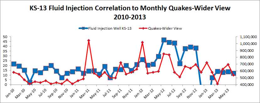
    Even more alarming is that a study of earthquake activity in the vicinity of Kilauea shows a direct correlation to the fluid injection (fracking) at the geothermal plant, as clearly illustrated by the following graph using scientific data:"
    Then the question of the ownership of the Puna Geothermal Venture and its purported links with the Rothschilds

    The Puna Geothermal Venture is owned by Ormat Industries, which is an Israeli based company that was founded by Lucien Yehuda Bronicki. A biography of Bronicki states:
    Mr. Lucien Yehuda Bronicki, Ph.D., served as the Chief Technology Officer of Ormat Industries Ltd. since July 1, 2004… He served as Chief Technology Officer of ORMAT Technologies Inc. Mr. Bronicki co-founded Ormat Turbines Ltd. in 1965. He served as President and Technical Director of ORMAT Turbines Ltd. from 1965 to 1991 … Mr. Bronicki has received numerous awards, including the Rothschild Prize for Innovation/Export in 1977. [emphasis added]
    It is quite plausible that the Rothschild’s 1977 support and financial backing made Bronicki and Ormat Industries obligated to do the Rothschild’s bidding in some way. This makes it possible that Bronicki was instructed by the Rothschilds to build the geothermal facility in a dangerous volcanic region for a hidden purpose despite the inherent risk in building a facility in such a dangerous area.

    And the links with the Hilna Slump and the possibility of a mega-tsunami

    This is where we need to consider Kilauea’s Hilina Slump, which is summarized in the following Wikipedia article:

    The Hilina Slump is a 5,000 cubic mile (20,000 kilometre³) section of the Big Island of Hawaii on the south flank of the Kilauea volcano. Between 1990 and 1993, Global Positioning System measurements showed a southward displacement of the south flank of Kilauea up to approximately 10 centimeters per year. The slump has the potential of breaking away at a faster pace in the form of an underwater landslide . In Hawaii, landslides of this nature are called debris avalanches. If the entire Hilina Slump were to slide into the ocean at once, it could cause an earthquake in excess of a 9 in magnitude, and a megatsunami. Previous megatsunamis in Hawaii 110,000 years ago caused by similar geological phenomena may have created waves 1,600 feet (500 m) tall.


    According to veteran investigative journalist, Hal Turner, he has received information that there is a news blackout on the Hilina Slump due to scientific concerns over its impending collapse and generation of giant tsunamis:
    Scientists from the United States Geological Survey (USGS) have contacted me regarding a staggering development taking place right now during the eruption of the Kilauea volcano in Hawaii:  An area of land on the south flank of the volcano known as the “Hilina Slump” – about the size of Manhattan – is moving and could BREAK OFF into the ocean, sending a Tsunami toward the west coast with 100+ foot waves moving at 500 miles per hour.  Cities like San Diego, Los Angeles and others could be wiped off the face of the earth. 

    And the illogical conclusions based on jumps in logic.

    If we accept what QAnon and Deagle have revealed about the Rothschilds, and what we now know about the link between the owner of the Puna Geothermal Venture and the Rothschild family, then this leads to a disturbing scenario. The decision to build the Puna Geothermal Venture in 1993 was ordered by Guy de Rothschild, after he and/or other Rothschild family members had called in a favor owed by Bronicki/Ormat after he was awarded the Rothschild Prize for Innovation/Export in 1977.

    Consequently, the hidden purpose of the Puna Geothermal Plant was to trigger earthquakes and seismic activity around Kilauea volcano that would lead to a collapse of the Hilina Slump. This would create a Pacific wide disaster that would cripple the U.S. economically and militarily for years to come, thereby helping the Rothschild family maintain its shadowy global control system, which plans to use China as its new base of operations.


    Here is a follow-up article
    Evidence Emerges That Hawaii Eruptions Caused By Fracking
    Hawaii volcanic eruptions caused by fracking


    30 May, 2018

    Scientific data has linked the surge in volcanic activity in Hawaii to increased fracking activity at Puna Geothermal Venture.

    The data shows how the fracking may have been deliberately designed to create a geological process by which lava would drain from Kilauea’s summit into the East Rift Zone so as to create large new vents that would destabilize the geology, and trigger a major collapse in the Hilina Fault System.


    Exopolitics.org reports: A video prepared by Pacific Tsunamic Warning Center clearly shows that the epicenter of earthquake activity centered in the lower Puna region is adjacent to the Puna Geothermal Venture.


    The following map by the US Geological Service shows where the Puna Geothermal Venture (marked PGV) is in relation to the current volcanic eruption.
    Here’s a photo showing the lava outbreak and its very close proximity to the Puna Geothermal Venture (circled in red) on May 22. Since then, it has begun flowing onto the property, but still not reached any of the wells.
    The scientific data clearly shows how the Puna Geothermal Venture (PGV) is at the epicenter of the volcanic eruption. Is this merely chance or by design?
    In my previous article and video published on May 15, I wrote about how the fracking activity at PGV has been scientifically linked to earthquakes. The following diagram was included which clearly showed the strong correlation:
    Since the publication of my article, there have been other articles linking the fracking at PGV with earthquakes, and also raising the question of whether the fracking caused the volcanic eruption. The most prominent one has come from Jon Rappoport, who wrote a May 22 article on his blogsite titled: “Did fracking cause the Hawaii volcano eruption?”
    In my May 15 article and video, I mentioned the Hilina Slump and how it may have been related to the fracking occurring at PGV. This has led to much criticism in the video’s comments section, but the scientific facts do show that earthquake activity is related to movements in the Hilina Fault System. Here’s a map showing the Hilina Fault System in relation to the East Rift Zone.
    The following map produced by the Hawaii Volcano Observatory shows how the recent earthquake activity led to the Hilina Slump slipping towards the Pacific Ocean Observatory by about two meters, which is massive in geological terms.
    Here’s how an article produced by the Berkeley Seismology Lab explained the above photo:
    While the earthquakes under the summit and under the eruption center at the eastern end of the rift zone are generated by the movement of magma, the big event and its aftershocks under the pali have a different origin. This becomes obvious in Figure 2 [reproduced above]. It shows how the permanent GPS stations installed and operated by the Hawaii Volcano Observatory moved in response to the 6.9 quake. The red arrows indicate the direction of horizontal motion and all of them point to the southeast. The length of each arrow represents the extent of the motion with the longest ones having moved by more than 2 feet. This shows that the flank of the cliff on the southern coast of Hawaii has moved further towards the ocean. 
    What the article didn’t mention was that the 6.9 quake on May 4 was triggered by the massive outflow of lava from Kilauea Summit, HalemaÊ»umaÊ»u crater, into the East Rift Zone. Basically, the volcanic eruption in the Lower Puna region (where the Puna Geothermal Venture is located) is being fueled by fresh lava from the summit of Kileaua, which is being drained towards it.
    While it began slowly as old lava oozed out of the new volcanic fissures in Leilani Estates, the recent upsurge is a result of fresh new lava arriving from the Kilauea Summit. The Honolulu Advertiser explained the process:
    The first weeks of the eruption saw pasty, crumbly, slower-moving aa lava oozing slowly through the fissures. But that changed Friday afternoon, scientists said, when preliminary results from a testing sample showed a different composite of lava, the smoother pahoehoe variety that is generally fresher, hotter and faster. 
    The following diagram shows the dynamics of the lava flows linking Kilauea Summit, the Pu’u’O’o Vent, and the East Rift Zone.
    An article by Scott Johnson in Ars Technica, explained the process as follows:
    KÄ«lauea’s main magma chamber seems to be a few kilometers below HalemaÊ»umaÊ»u Crater at its summit. When the volcano’s guts gurgle with a new injection of magma from below, the lava lake in HalemaÊ»umaÊ»u Crater rises. The conduits and crevices that constitute KÄ«lauea’s “plumbing” extend from the summit region over to the East Rift Zone. So after lava rises in HalemaÊ»umaÊ»u Crater, the lake sometimes drains back down as the new magma moves on toward the eastern section of the volcano.
    This is where we finally get to the issue of whether the fracking at Puna Geothermal Venture was secretly an attempt to weaken the underlying geology in order to create a path for fresh lava to drain from Kilauea summit into the East Rift Zone. As the following diagram of the East Rift Zone illustrates, lava follows the path of least resistance in a highly pressurized environment.
    This principle would be well known to any geologist, or plumber if we use Johnson’s analogy. This means that some would have been aware from the inception of the PGV in 1993, that the process of using highly pressurized water on subterranean rocks (aka fracking), severely compromising the underground environment, would effectively open up a new path for lava to flow from the Kilauea summit and the Pu’u’O’o Vent
    Apparently, this is exactly what was planned by those behind the Puna Geothermal Venture according to Paul Collin, who has strong ties to the U.S. intelligence community:
    It is understood that Hawaii’s geothermal power company “Puna Geothermal Venture” (PGV) purposefully “drilled” wells and “fracked” into the ground in such a way that lava from Earth’s mantle would eventually be redirected to open-up and spout a ‘brand new volcano within the island of Hawaii, and sure enough facts set forth by a USGS chart and briefing that lava has now been routed right along the same linear path south-east, which actually punched-out a ‘brand new caldera volcano’ within the “Lower East Rift Zone” adjacent to the extremely weak debris landmass known as the ‘Hilani Slump’ consisting of 10% of Hawaii’s southeastern land mass that was already slipping into the Pacific Ocean ‘without the new lava delta’ growing huger; about 400 meters per hour on land (alone) – threatening a tsunami event from coast to coast.
    In my May 15 article, I described how the creation of a massive tsunami through a collapse of the Hilina slump was the secret purpose behind the creation of the Puna Geothermal Venture, whose owners are linked to the Rothschild family.
    I wish to state for the record that I don’t believe the plan will succeed, and that the hoped-for megatsunami that would cripple the United States economically and militarily for decades to come will not occur. However, it is vitally important to expose this plan was and who is behind it.
    My view is that the Rothschild family has chosen China as the hub for the kind of New World Order that the Deep State/global elite would like to emerge. That would be an openly authoritarian state where AI technology is used to monitor citizens and quickly remove troublemakers expressing dissenting political views.
    The United States is the main obstacle to such an authoritarian New World Order being created, and secret geo-engineering was therefore undertaken in Hawaii that would create a megatsunami via a major collapse of the Hilina fault system.
    If the plan had worked, then it is not hard to see how the U.S. would have been unable to prevent a New World Order emerging – based on China’s authoritarian socio-political model masked behind AI technology designed to appeal to a tech savvy Millennial generation.
    It is also important to mention that this is the second time in 2018 that Hawaii was targeted by the Deep State/global elites for some kind of catastrophic event that would economically and militarily weaken the United States. On January 13, 2018, a ballistic nuclear missile was sent by a secret CIA linked Navy, called the “Dark Fleet”, in a false flag attack that was meant to embroil the United States in a catastrophic nuclear war.
    In a January 20 article, I provided documents and references showing how the CIA has built its own secret fleet that conducts covert operations on behalf of the Deep State/global elite. Thankfully, that plan failed due to the intervention of a U.S. Air Force based secret space program that shot down the missile, as I discussed another article.
    Since 2004, I have lived on Hawaii’s Big Island. On May 1, 2018, I moved from the lower Puna region just as the earthquakes intensified, to the Kona side of the Big Island. It boggles the mind that such a beautiful part of our planet is being repeatedly targeted by the global elite for catastrophes that will facilitate their New World Order plans.
    I sincerely hope that appropriate legal and political action is taken against: all those behind the Puna Geothermal Venture for their role in the devastation that is being caused in the lower Puna region by their secret fracking; the local County officials that were likely bribed to remain silent over the risk of permitting such a venture; and also against the global elites who put together such a nefarious plan.