

North
Island New Zealand prepares for drenching after Cyclone Debbie

*Via Facebook
***SIGNIFICANT
WEATHER EVENT COMING THIS WEEK**** TARANAKI, WHANGANUI, MANAWATU,
HOROWHENUA, KAPITI COAST, WELLINGTON, WAIRARAPA, MARLBOROUGH AND
NELSON. DONT FORGET TO ADD YOUR FRIENDS AND FAMILY WHO MIGHT BE IN
THESE AREAS AND NOT ON MY WEATHER PAGE YET.
PLEASE
SHARE AND LIKE THE POST!!
#SEVEREWEATHERWATCH
REMNANTS
OF CYCLONE DEBBIE ARE HEADING OUR WAY.
A
SLOW MOVING RIVER IN THE SKY APPROACHES FROM THE NORTHWEST AND A
BLOCKING HIGH DEVELOPS IN THE EAST, Anyone living in a low lying
areas, that's prone to flooding be warned now.
Im
currently going through all the weather maps and getting as much
detail as i can. Im doing my best to give you accurate weather
information as it comes in. Im one man and not a trained
meteorologist only self taught. But i love the weather and it really
fascinates me, thank you all for your support.
FORECAST:
When
does it begin? Early hours Monday morning some showers develop which
turns to rain off and on throughout the day nothing major and
unusual. However by Monday evening heavier rain could develop after
dark. Taranaki gets the first signs of heavy rain before it drifts
slowly down the coast affecting the Horowhenua and Kapiti coast
areas.
TUESDAY:
KAPITI COASTERS you guys are exposed to the weather from this
direction, watch out that rain will be heavy. Northwest winds will be
gusty. If you dont need to go out don't bother its going to be
shizzer, Rain with heavy falls even torrential for some areas all day
long!!!!!. Flooding highly likely....don't go near any rivers, watch
from a good distance if you do. Hutt Valley and Wellington. Rain all
day for us. Watch the Waiwhetu stream.
Wairarapa
you are also in for some rain as well.
From
my knowledge and reading the weather models so far, up to 300mm of
rain could fall in some areas over the 3 days. The majority of the
heaviest rain is likely to be on Tuesday.
WEDNESDAY:
Morning still heavy rain at times main trough now moves over the
entire Marlborough/Nelson area with torrential falls particular
around the Nelson/Golden Bay region. Rain eases during the day for
some areas in the lower North Island. But Northwest winds likely to
increase as the low gets closer to the west coast.
Winds
will definitely strengthen due to the barometric pressure dropping in
the low's centre as it gets closer to the top of the south island.
THURSDAY:
Passing cloud, gusty northwest winds. Rain off and on throughout the
day, Low now passes over the southern alps moving out to sea off the
east coast. Rain showers continue on Thursday evening for most place.
Winds start changing to the south on Friday. Further details to come.
What
you can expect:
*Humid
warm conditions are likely as the ex cyclone brings all this warm air
with it from the tropics.
*Possibly
severe winds, North to Northwest winds.
*
Unsure about Thunderstorms just yet, will keep you posted.
Driving
rain at times, with torrential downpours possible these down pours
could be localized. Some places may just get steady rain. But due to
its prolonged period Flooding is highly likely for some low lying
areas.
Rimutaka
Hill would be one place to watch for slips if you are traveling this
way during the week.
Some
will no doubt say what storm? not bad at my place. Bear in mind you
may be sheltered from the wind/rain. This event is over a duration
period of 3 to 4 days, conditions finally start easing on Thursday
into Friday.
*This
storm is slow moving, the blocking high in the east is basically
crushing the low pressure system against another high that's sitting
under Australia, this is then pushing the rain clouds higher into the
atmosphere, which means they are holding a significant amount of
water. This water is then released as rain once it meets the
mountains. Its practically a river in the sky.
Have
a great Sunday evening. Keep me informed of the conditions at your
place over the coming week. Hopefully no spelling mistakes lots of
writing. lol. Thanks again Daniel
3 April, 2017
Wellington and central New Zealand will bear the brunt of downpours and strong winds this week in the wake of Tropical Cyclone Debbie.
A collection of fronts was sitting around central New Zealand early on Monday, MetService duty forecaster Matthew Ford said.
Wellington is set for a deluge of double its usual rainfall for April over 48 hours with rain forecast from Monday through to Wednesday, with southeasterlies rising to gale strength in exposed places on Tuesday, when a high of just 13 degrees Celsius was expected.

NZTA
Fog rolling over Auckland's southern motorway in this webcam image from about 8am on Monday morning.
On Monday the capital was expected to get to 16C, despite strong southerlies.
A southerly push had come up the east coast of the South Island and had extended over the lower part of the North Island. At the same time there was a fairly moist northerly airstream over much of the North Island.
A busy severe weather outlook! http://bit.ly/SWOutlook
. Confidence levels are for rain/wind reaching warning criteria (i.e 100mm in 24h) ^SG


"The two are colliding over central New Zealand," Ford said. "Debbie hasn't quite come down yet."
The warm moist air that had come down from the north and settled over much of the North Island had brought low cloud and drizzle.
MetService forecasted the centre of the country likely to have the most days of rain during the week.
The wettest days were expected to be Tuesday and Wednesday.
For some the #TropicalTorrent may drop 2-3 times the normal rainfall for the entire month of April in just 2-3 days.


Auckland Airport was reporting light fog around 6am Monday but said it wasn't affecting flights.
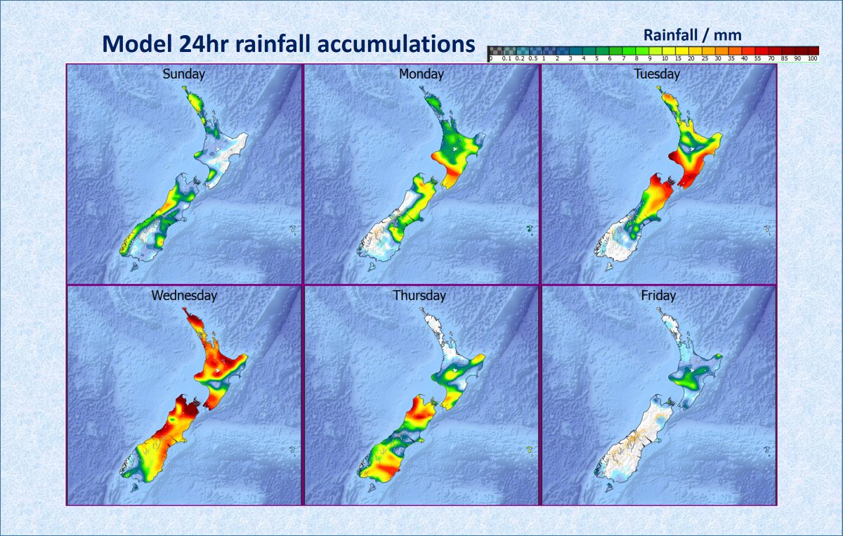
High Impact Rain Event This Week! Here are the 24 hour model rainfall accumulations. Keep yourself updated at http://bit.ly/metservicenz
^SG


MetService meteorologist Stephen Glassey said the deepening low left over from the remnants of Cyclone Debbie were expected to bring heavy rain and strong winds to many areas - mostly from Tuesday to Thursday.
HEAVY RAIN WARNING - WAIRARAPA (away from the Tararua ranges) - From midnight Monday to noon Wednesday expect 120-160mm. 10 to 20mm/hr.


It was important to note the weather system bore little resemblance to a tropical cyclone other than the fact it contained loads of tropical moisture, bringing with it the potential for heavy rain, Glassey said.
HEAVY RAIN WARNING - TARARUA RANGES - From 6am Tuesday to midday Wednesday, 200 to 250mm of rain may accumulate. Peak intensities 20-30mm/hr


No comments:
Post a Comment
Note: only a member of this blog may post a comment.