Showing posts with label Svalbard. Show all posts

Friday, 13 September 2019

No ice around Svalbard


Warm water, fresh water, 

wind and tides – ice or no ice 

around Svalbard?


12 September, 2019


September onboard the research vessel Lance north of Svalbard. Kristen, our mooring engineer, is happy. There is no sea ice to be seen anywhere – ideal conditions to find the instruments we left here two years ago attached to a rope, anchored to the seafloor, and held upright under water by several buoys.
By: Angelika HH Renner and Sigrid Lind // Institute of Marine Research. Arild Sundfjord // Norwegian Polar Institute

1.

Without ice, Lance is free to move around and locate the mooring using the ship’s echo sounder. Kristen sends the command to the mooring to let go of the anchor, and the rest of us scan the water surface. Luckily, the buoys are easy to spot when they come up. The crew lifts everything onto the deck, and a little later, we have two years of temperature, salinity and current data in our hands. They will help us understand how the ocean is changing around Svalbard.
In recent years it has become increasingly normal that the ocean around Svalbard is free of sea ice. While this is good news for ship traffic, fisheries, and potential other exploitation of resources around Svalbard, a shift towards an ice-free normal can also be seen as an alarming sign of drastic changes in the climate system.

TOP PHOTO:

Jon Leithe / Norwegian Polar Institute 
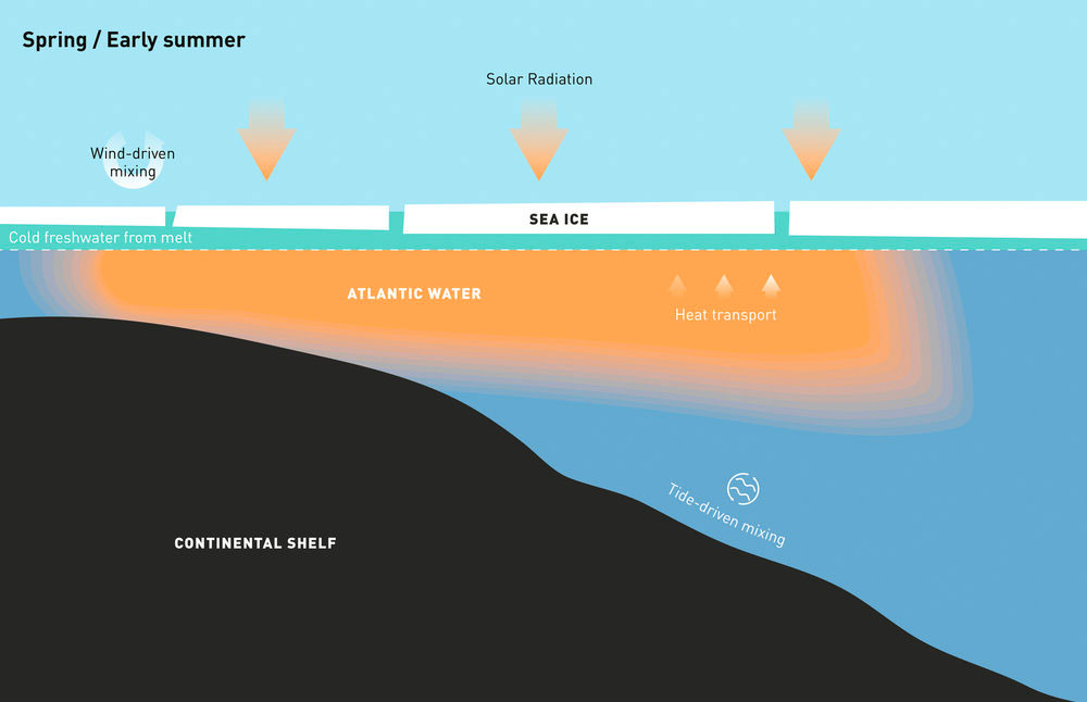
Svalbard is at the front between the Arctic and Atlantic domains. This is the entrance to the Arctic Ocean where large amounts of heat are brought in with the Atlantic Water current – a continuation of the Gulf Stream flowing northward along the Norwegian coast and around Svalbard. When Atlantic Water enters the Arctic, it encounters fresher Arctic waters. Since the Atlantic Water contains more salt and is denser, it becomes submerged and continues into the Arctic Ocean below the Arctic Water. This means that the Arctic Ocean is stratified, with a cold and fresh Arctic layer above a warm and saline Atlantic layer. The Arctic layer thus restricts the amount of heat that comes up from below, enabling sea ice to form and persist in cold winter conditions.
2.

But these patterns are changing. New research at the Fram Centre reveals an altered inflow of warm water and ongoing changes to the stratification (i.e. the gradient between fresher surface layers and more saline Atlantic Water) and emphasises how these changes play a key role in enhanced warming and reduced sea ice cover in this region.
North of Svalbard, Atlantic Water is carried by a narrow current along the continental slope and is pushed below a layer of Arctic Water as it travels eastwards. In recent years, the Atlantic Water has been able to continue at the surface further east than before throughout much of winter. The Fram Centre “Arctic Ocean” Flagship project A-TWAIN has been monitoring the Atlantic Water boundary current since 2012 using an array of moored instruments north of Kvitøya. Results from this project show how the heat in this boundary current, in combination with wind-driven mixing and tides, has contributed to keeping the region free from sea ice until the middle of winter, when sea ice appears and a cold and fresh meltwater layer is established.
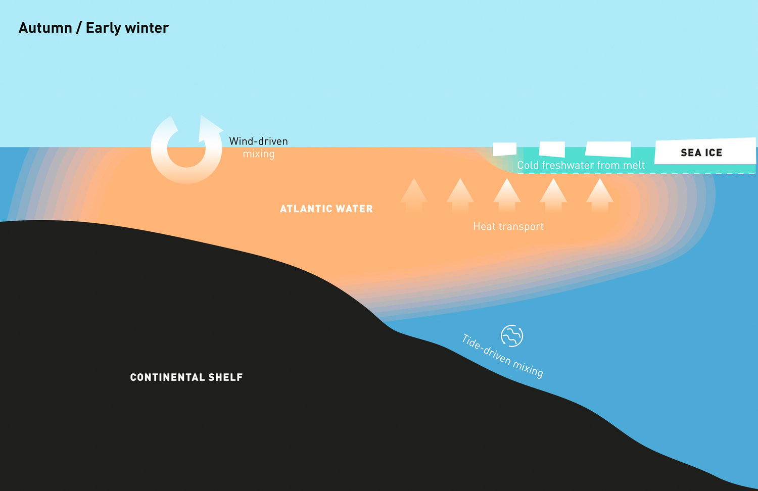
This thin layer of cold water, which can be formed locally by sea ice melt or can be moved in from the north by wind, protects the sea ice cover from the Atlantic Water heat below.
The largest inflow of warm water from the North Atlantic occurs in autumn and early winter. During this time of the year, large pulses of water with temperatures of up to 5°C arrive at the continental slope north of Svalbard. With longer periods of open water, the wind will mix the upper part of the water column more efficiently, and the surface will not freeze despite very low air temperatures and the sun being below the horizon. It is only when the temperature and volume of incoming warm water decrease later in winter, and the surface becomes sufficiently cold and fresh, that sea ice forms locally, or that sea ice blown into the region from the north, can persist and not be melted by the Atlantic heat.
Behind the front in the northern Barents Sea, the layer of fresher Arctic waters is thicker and more persistent than north of Svalbard: winter-cooled water with temperatures down to freezing-point occupies the upper 100 m of the ocean. Here, the “Arctic layer” persists and remains cold through the summer, thereby making the conditions ready for sea ice growth earlier in autumn and winter.
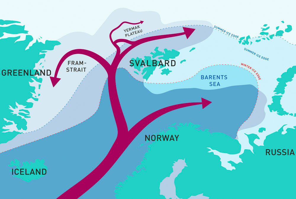
Atlantic Water flows into the Arctic with the continuation of the Gulf Stream and splits into several smaller currents. The star indicates where the A-TWAIN array is moored north of Kvitøya.

3.

FURTHER READING

Renner AHH, Sundfjord A, Janout MA, Ingvaldsen RB, Beszczynska-Möller A, Pickart RS, Pérez-Hernández MD (2018) Variability and redistribution of heat in the Atlantic Water boundary current north of Svalbard. Journal of Geophysical Research 123(9): 6373-6391, doi:10.1029/2018JC013814

Lind S, Ingvaldsen RB, Furevik T (2018) Arctic warming hotspot in the northern Barents Sea linked to declining sea-ice import. Nature Climate Change 8: 634-639, doi:10.1038/s41558-018-0205-y
The Institute of Marine Research together with its Russian partner, PINRO, have been monitoring the marine environment in the Barents Sea in late summer since 1970. A new study using this extensive set of observations of ocean temperature and salinity shows that vertical mixing between the Arctic and Atlantic layers brings up heat and salt. The salt flux means that a freshwater input is needed to sustain the freshwater reservoir and stratification. Using satellite data in combination with the hydrographic data, the study shows that sea ice import into the Barents Sea is the most important freshwater source.
Recently, a decline in sea ice import and freshwater input has led to a major loss of freshwater, weakened ocean stratification and facilitated efficient vertical mixing between the layers, resulting in extreme warming of the Arctic layer. This heat is then released to the atmosphere in winter. This contributes to the development of the Barents Sea as a hotspot of Arctic warming, with the highest rates of atmospheric temperature rise and winter sea ice decline in the Arctic. Unless the freshwater input recovers, the stratification can break down and the entire region could become part of the Atlantic domain, where Atlantic Water occupies the entire water column.
The fresh surface layer in the northern Barents Sea is maintained by melting sea ice imported from the Arctic Ocean and is thus thicker during summer when more ice melts. The sea ice cover and the freshwater layer support each other’s presence. North of Svalbard, both sea ice and the surface freshwater layer are strongly influenced by wind, and fresh water is brought in both through sea ice melt and by advection from further north and east in the central Arctic.
As climate change is leading to strong warming in the Arctic, both in the ocean and in the atmosphere, and to a drastic decline in sea ice extent in all seasons, less sea ice is transported into the northern Barents Sea, and local freshwater volume decreases. This, in turn, allows the upper ocean to warm dramatically from below, contributing to the fastest temperature increase and greatest winter sea ice decline yet observed in the Arctic. North of Svalbard, the sea ice is thinning and melting faster than before, enabling the Atlantic Water to stay at the surface further east than it used to. Prolonged ice-free periods will enable more direct influence of the wind on mixing in the ocean. At the same time, the efficiency of tides in redistributing heat might change as stratification weakens.
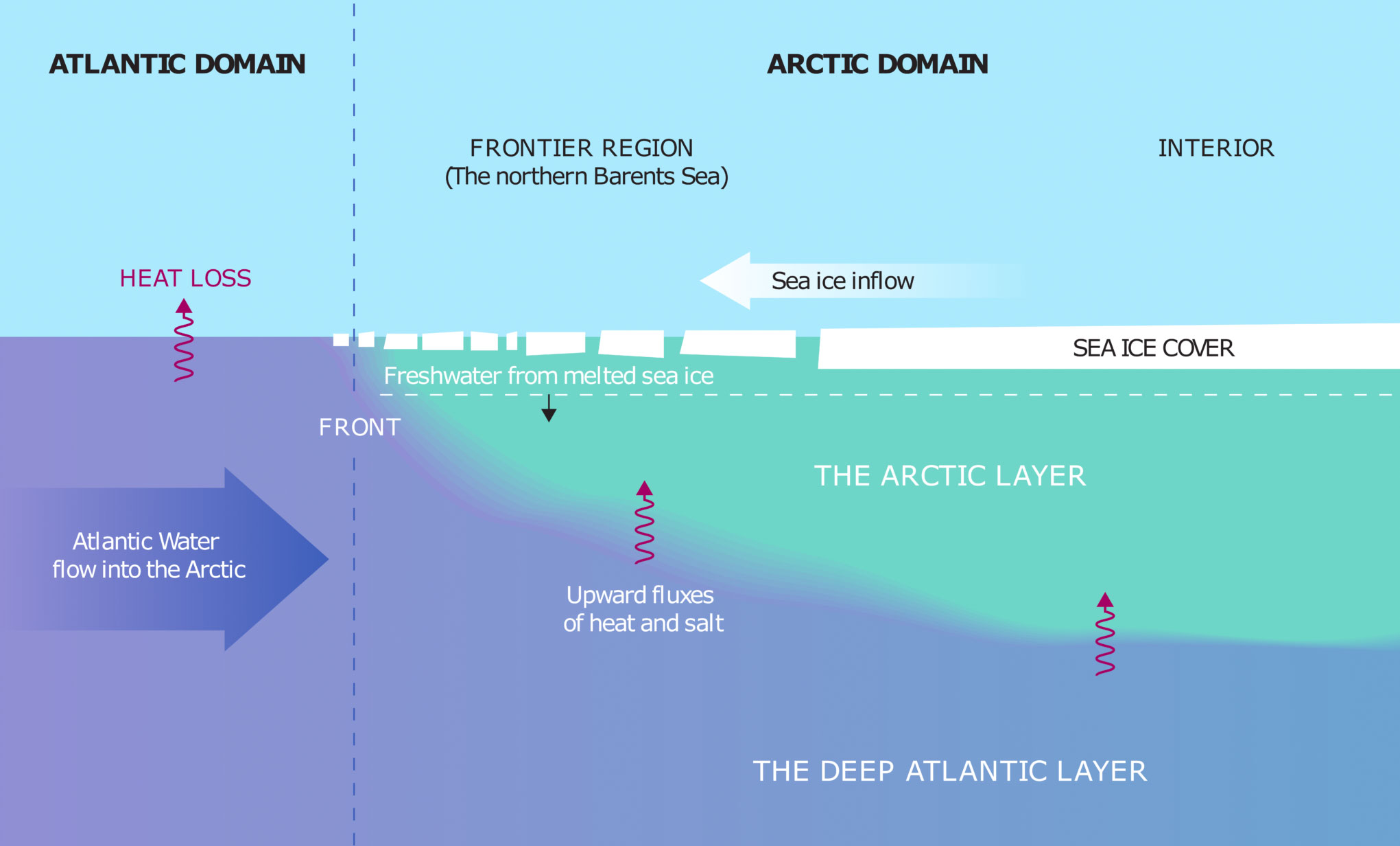
Illustration: Reibo/Sigrid Lind, Institute of Marine Research

4.

It will be important to follow this region closely in the coming years. The A-TWAIN mooring array north of Svalbard is continuing to record the properties of the inflowing Atlantic Water boundary current, and new projects will help extend the array. Later in 2019, Kristen will be back at sea to search for the moorings, recover the instruments, and put out new moorings so that we can slowly build up a longer time series also in this region.
The annual monitoring of the Barents Sea by IMR and PINRO continues and is being extended with the new icebreaker RV Kronprins Haakon.
The Nansen Legacy project expands the interdisciplinary research, enabling us to include more chemical and biological parameters in our work and to further investigate linkages between the northern Barents Sea and the region north of Svalbard, the entrance to the Arctic. With the observed rapid climate change, will larger parts of the Eurasian Arctic shift towards an Atlantic climate? Will a new frontier region develop further east in the Arctic? How will the ongoing changes affect societies and ecosystems around Svalbard, the Barents Sea and the Norwegian mainland? The Fram Centre with its partner institutions and key projects are in a very good position to take a lead in understanding how our region will develop in the near future.

Sunday, 23 June 2019

Strange skies and a methane burst over Svalbard - 19 June, 2019


Strange skies over Svalbard and a methane burst – 19 June, 2019


There has been what is an increasing phenomenon of strange cloud formations over Novaya Zemlya in Northern Siberia and Svalbard (which coincided with a methane burst).I give my musings as to what this might be about.


 Novaya Zemlya on the 21th June


Svalbard on the 19th June

Focusing in...


A methane burst on the same day


Wednesday, 12 June 2019

CNN produces an article on Arctic sea ice melting from below

Arctic melt: Threat beneath the ice

We know the Arctic is experiencing a vast melting of sea ice. But deep in the ocean, something is happening that scientists are still trying to fully understand


CNN,
8 June, 2019


Fram Strait, Arctic Circle (CNN)It's spring in the Arctic, and nature in the far north is just waking up, warmed by 24 daily hours of sunlight.

Here, in the waters of the Fram Strait, between Svaalbard and Greenland, is where ice comes to die.


Fram Strait, Arctic Circle (CNN)It's spring in the Arctic, and nature in the far north is just waking up, warmed by 24 daily hours of sunlight.


The Arctic is heating up twice as fast as the global average, causing massive melting of sea ice. But while we know climate change is warming the Arctic air, there is a lot more happening under the ice that we don't fully understand.


A team of interdisciplinary scientists is here on a study facilitated by Greenpeace, at the start of the environmental group's nearly year-long pole-to-pole expedition. The scientists want to learn more about this threat beneath the ice, which could potentially destroy the cycle of life that starts here, and threaten the lives of people all over the planet.


A mosaic of fractured ice

The inflatable boats carrying the scientists maneuver slowly through a sea of fractured ice, a mosaic of pieces that once were part of the Arctic ice sheet, pushed south by winds and currents into the Fram Strait.


Here, the scientists spend days working on top of the precarious ice floes, keeping a watchful eye out for polar bears while drilling into the ice to measure its thickness

"It has definitely thinned in this area, it has thinned everywhere" says team leader, polar physicist Till Wagner, of the University of North Carolina Wilmington.

Since 1990 the thickness of sea ice here has decreased by a third, from about 3 meters to 2 meters, according to the Fram Strait Arctic Observatory.

The Fram Strait is where warm waters originating in Mexico are brought up by the Gulf Stream, flowing thousands of miles through the Atlantic to meet the Arctic ice edge. 80% of the ice movement in and out of the Arctic Ocean happens through here.

"For the longest time the story of sea ice loss has been one of the higher air temperatures melting the ice from above," Wagner explains.

But that story may be changing.

"This warm water is at the surface as it comes up [from the south] and then it drops under the ice as it goes into the Arctic Ocean," says Wagner. "The layer that is under the ice has been coming up closer to the surface and melting the ice from underneath."

The researchers are trying to better understand exactly why this is happening.


A forest of microscopic life


What the sea ice melt does to the ecosystem, and to us, is at the heart of this study.

Measuring the thickness and density of a recently extracted ice core.
.

The scientists extract ice cores from the floes, which hold clues that are invisible to the naked eye.

Read: Arctic's 'last bastion' of sea ice is breaking up for the first time
"Oh wow, that's beautiful," exclaims biological oceanographer Mattias Cape, examining a meter-long cylinder of ice. "Inside this piece of ice is this microscopic forest; all these little bubbles, these little channels are home for these microscopic organisms."


Greenpeace's Arctic Sunrise has been converted into a floating lab and on board, ice core samples are distilled and examined. Under the microscope the frozen clues within come to life -- a kaleidoscope of sea ice algae and phytoplankton, microscopic organisms that use sunlight for energy.


Cape explains that these organisms play a vital role in reducing climate change by pulling planet-warming carbon dioxide from the atmosphere and storing it as a long-term "carbon sink."


"They photosynthesize and take in CO2 and expel oxygen as part of the process -- which is the oxygen we breathe," he says.


They will be further tested later on land, helping us understand how sea ice loss is potentially impacting their ability to take in and sequester CO2.


Web of life

These waters might look barren, but they are hugely productive when it comes to the building blocks of ocean life.


The underbelly of the ice teems with zooplankton -- tiny crustaceans that feed on the phytoplankton. In turn krill and smaller fish feed on the zooplankton, big fish feed on the smaller fish and so it goes on up a food chain that includes whales, seals, sea birds, and even polar bears.


As the sea ice melts, ice algae and phytoplankton are released into the sea. In the short term, this creates something of a nutrient injection that jump starts the cycle of life in the ocean.


But this April saw a record loss of sea ice across the Arctic. Less ice ultimately puts that entire cycle at risk, with a smaller nutrient injection meaning less food further up the chain.


The team's study confirmed their expectation.


"In the top layer [of the ocean] you see there is a ton of biomass between 10 meters and 30 meters" Wagner says.


"And then right below there is this warm water, that is almost 3.5 degrees and this is the warm Atlantic water" Cape adds.


In this warmer water, away from the ice, they found significantly less phytoplankton.


Freshly melted ice not only injects life into the water -- it creates a layer of cold water that protects sea ice above from more melting.


"It isolates the ice from the hot devil water sitting at the bottom waiting to come up" Wagner explains.


Less sea ice means there will be less of that protective cold layer, leading to even more melting.


Saturday, 6 April 2019

What is going on at Svalbard?


A methane event at Svarlbard?


The following was sent to me by David Allcock – with many thanks

“I think a methane event is taking place off the coast of Greenland on the edge of the shelf. Nothing on cams yet though !!!!”

This shows the topography....


And the warm water that has been around for a while...

 The temperature of the water is up to 14.7 degrees Celsius.


Sunday, 3 February 2019

Methane emissions report - 02/02/2019

Methane emissions in the Arctic – an update - 02/02/2019

Yesterday a video came out from Yale University and USGS telling us that methane from the permafrost is a potential problem in the future. It also said the methane clathrate gun is just a "nothing burger", a conspiracy theory.


So does that mean that we can just pack up and go for a holiday, assured in the knowledge that there is nothing to worry about?

I prefer, more -and-more every day NOT to listen exclusively to the scientists (certainly not all of them!) but to take my own counsel.

Just by looking at the data from ostensibly trustworthy sources we are able to divine what might be going on. It is all that we can do as we are not on the ground.

But neither are the "experts".

So let's go through the data.

Firstly there is the data from CAMS (Copernicus) which appears to have been changed yet again in that I was unable to select the beginning date for the data, essentially meaning I should be recording this every day so it is not lost.


This shows the continuation of releases of methane, notably from the east side of Novaya Zemlya and from the ESAS in addition to releases from land.

The whole question of sea temperature remains of sea surface temperatures where there is ice and what this implies for the formation of good-quality ice in seas that appear, from the data, to be hovering around zero despite much colder atmospheric temperatures.

I demonstrate and discuss this in the following video.


Here is the temperature near Novaya Zemlya


And the sea surface temperatures.


Here is data for sea surface temperature  anomalies. They do not provide data in areas that are covered in ice.


Here are the temperatures according to Climate Reanalyzer


https://climatereanalyzer.org/wx/DailySummary/#sstanom

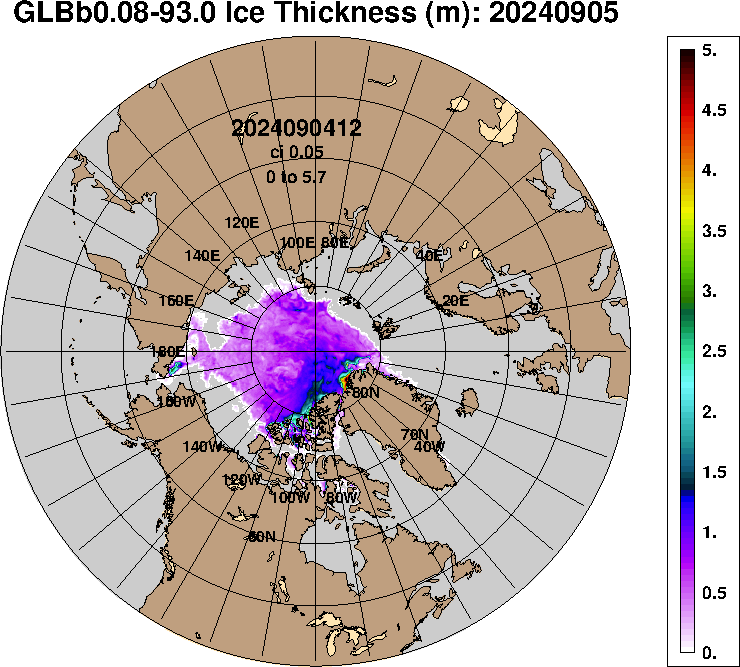
And here is the sea ice thickness as measured by the US. Navy


Friday, 18 January 2019

What is all that methane in the Arctic Ocean?

The following was a helpful comment on Margo's video that corresponds with our own view of what might be happening:

"Hi Margo, not had time to catch up with all your videos, but was looking at CAMS and Climate Reanalyser today and realised that the methane plumes in the Arctic are actually coming through the ice off the eastern side of Novaya Zemlya and in the East Siberian Sea. How is that even possible?"

What follows is an attempt to address this question.
Is methane coming up from below in warmer Arctic seas?


Yesterday Margo made a video (which can be seen HERE) in which she showed alarming evidence that methane is coming in large concentrations up the east coast of Novaya Zemlya in western Siberia as well as (in smaller concentrations) at the East Siberian Arctic Shelf (ESAS).


At what temperature does salt water freeze?

First a matter of clarification,

In the video I stated that salt water freezes at minus 21 C whereas other sources say minus 6C.

My source for this is: 

"Pure water freezes at 32 degrees Fahrenheit, (0 degrees Celsius) while a salt solution may not freeze until it reaches minus 6 degrees Fahrenheit (minus 21 degrees Celsius)because salt disrupts the movement of molecules entering and leaving the solid."


https://governmentshutdown.noaa.gov


(I have added the conversions to degree Celsius)

Basically the freezing point of water depends on the degree of mixing of fresh and salt water. Arctic water is likely to freeze at somewhere between 0C and -21C.

Here is an illustration of sea surface salinity which shows a high degree of mixing in the North Atlantic but also relatively high levels of salinity in the Siberian sector of the Arctic Ocean.


If you want more on this read this item from Wikipedia


An interesting point from this article was this: 

"Because earth's insulating crust is much thinner under the oceans than under the continents, most of the earth's internal heat escapes into the oceans. Although the temperature of the air at an ocean's surface may be freezing, the temperature of the water deep in the ocean is significantly warmer due to internal heating".

***


Sea surface temperatures are mainly just below freezing


What are the indications that methane might be coming up from below through the ice?

Firstly, here is data from the US Navy site on ice thickness:


The data for sea ice concentration shows 100 % except for areas in the North Atlantic and the Bering Strait.


We come now to the all-important question of sea surface temperature.

Nullschool has a feature with measurement of sea surface temperature (even where there is ice, it seems)

According to that there is a warm area (seen below) of warm ocean that measures up to 16.2C.


For contrast, compare that with the Cook Strait in New Zealand in summer and in the midst of a marine heatwave.

A temperature of 18.2 degrees Celsius!!


If you go a little north from Svalbard the sea surface temperature  is minus 1.8 degrees Celsius.


Note, this area of the Arctic (in the North Atlantic is still ice-free


Meanwhile, temperatures at the south of Greenland are 2.4 degrees Celsius.


As a reminder. this is almost-but-not-quite in darkness.


Sea surface temperatures in Siberia and methane releases

Getting back to the methane...

According to Nullschool temperature to the east of Novaya Zemlya are minus 1.4C.


Given that a proportion of the water will have a certain amount of salinity mixed in which means that the water has not completely frozen and the probable quality of the ice will be very low.

It is a surprise to learn that Nullschool gives sea surface temperatures in areas which are frozen.

According to this, sea surface temperatures are minus 1.8 degrees Celsius.


Taken together, this would indicate that it is indeed possible for methane to be coming up to the surface from below and being released into the atmosphere.

Like the ESAS the seas around Novaya Zemlya are shallow enough for methane from clathrates to reach the surface

"The Pechora Sea is quite shallow, its average depth being only 6 m. The deepest point reaches 210 m. In the southern part of the sea runs the eastward-flowing Kolguyev Current."


I would surmise that given that it is winter and there is ice (whatever its quality) that only a part of the methane is being released into the atmosphere.

It is totally unexpected to see methane released into the atmosphere in winter and yet that is what I think is happening.

One can only begin to imagine how all this will look under conditions of ice melt and warmer-still seas.

Caveat and a provisional conclusion

All of the above is based on observations from data sources that we trust are accurate. There is no way to confirm whether this is the case. 

My conclusion is that, given the above and information that has come out in the last few days is that we are in totally uncharted territory.

Some scientists (members of the "Priesthood" as call it) may pretend they know what is going on.

They don't, especially those sitting behind their computers working with their flawed models.

This is how science has always worked:


"Nikita Zimov was teaching students to do ecological fieldwork in northern Siberia when he stumbled on a disturbing clue that the frozen land might be thawing far faster than expected.


Zimov, like his father, Sergey Zimov, has spent years running a research station that tracks climate change in the rapidly warming Russian Far East. So when students probed the ground and took soil samples amid the mossy hummocks and larch forests near his home, 200 miles north of the Arctic Circle, Nikita Zimov suspected something wasn't right."


In conjunction with our own observations it is these two pieces of news from the last few days that have put the wind up me.

Data from two Arctic sites suggest some surface layers are no longer freezing. If that continues, greenhouse gases from permafrost could accelerate climate change.


Polygons formed by the annual freezing and thawing of ice wedges just below the earth's surface are visible from above near the Northeast Science Station in Cherskiy, Russia.


Unprecedented changes required to ensure accuracy of system that guides everything from aircraft to smartphones