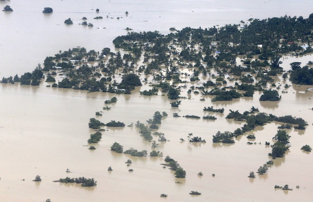
Hundreds dead, millions displaced as monsoon rains batter Asia
Monsoon
rains have claimed the lives of hundreds of people across the Asian
continent, authorities said Monday, as rescue workers scrambled to
reach remote areas of India, Pakistan and Myanmar in the wake of
flash floods and landslides

Scores
have also perished in India, Nepal, Pakistan and Vietnam following
floods and landslides triggered by heavy seasonal rains
The
toll from flash floods and landslides in Myanmar caused by days of
torrential rain is likely to rise, the UN warned Sunday, August 2, as
monsoon downpours heaped misery on thousands across the region.
At
least 27 people have been killed and more than 150,000 affected by
flooding in Myanmar in recent days, with the government declaring the
four worst-hit areas in central and western Myanmar "national
disaster-affected regions".
Scores
have also perished in India, Nepal, Pakistan and Vietnam following
floods and landslides triggered by heavy seasonal rains.
Rescue
work in Myanmar has been hampered by continued downpours and the
inaccessibility of many of the remote regions battered by the
deluges.
Myanmar: Aid arrives for victims stranded by floodwaters
Another Category 5 Cyclone: Super Typhoon Soudelor
Super
Typhoon Soudelor vaulted
to Category 5 status on Monday, making it the planet's sixth (at
least--see below) Category 5 storm of the year. At 2:00 pm EDT
Monday, Soudelor’s sustained winds were estimated at 180 mph, with
the strength unchanged in the 8:00
pm EDT Monday update from
the Joint Typhoon Warning Center (JTWC).
For the year thus far,
Soudelor is Earth’s strongest tropical cyclone in terms of
estimated wind speed. The Weather Channel’s Nick Wiltgen notes that
Soudelor’s estimated central pressure of 900 mb is the lowest in a
typhoon since last year’s Super Typhoon Vongfong, also 900 mb. Five
prior Category 5 storms this year were described and illustrated in
a May
19 post.
They include Tropical
Cyclone Eunice, Cyclone
Pam, Super
Typhoon Maysak,
and Super
Typhoon Noul. Update: Our
initial survey of JTWC products showed that Cyclone
Bansi fell
short of Category 5 status.
However, JTWC
data for Cyclone Bansi archived by RAMMB-CIRA indicate
that Bansi's estimated winds peaked at 140 knots (about 160 mph) at
0000 GMT on January 13.
If we include Bansi, then we're now up to a
startling seven Category
5 storms so far in 2015. This compares to a yearly
average of 4.6 Category 5 storms for
the period 1990-2014.
It's not out of the question we could break the
record total of 12 Category 5 storms notched in 1997, when--much like
this year--a strong El Niño was ramping up.
Thanks to wunderground
member 1900hurricane for
bringing Bansi data to our attention.
Middle
East swelters in heatwave as temperatures top 50C
Intolerably
high temperatures and soaring humidity are close to breaking
meteorological records across region

4
August, 2015
A
heatwave has engulfed much of the Middle East, sending temperatures
and humidity soaring throughout the region.
The searing heat, ailing infrastructure and power cuts have combined to create a particularly intolerable climate in an area already notorious for its hot summers.
The searing heat, ailing infrastructure and power cuts have combined to create a particularly intolerable climate in an area already notorious for its hot summers.
In
the southern Iraqi city of Basra, temperatures are expected to hover
around 51C for most of the week and reach 52C at the weekend.
In
Iraq, the government ordered a four-day holiday to help people deal
with the heatwave, while residents in Lebanon without electricity
have taken to sleeping on bare floor tiles to cool themselves amid
the electricity cuts, unable to operate their air conditioning.
In
Beirut, nestled on the Mediterranean coast, temperatures will hover
in the 30s, but humidity levels of over 50% and the city’s
increasingly frequent power cuts have combined to create an
oppressive heat that has residents sweltering, just a week after
stinking garbage piles spilled over into the city’s streets in a
crisis that highlighted the government’s chronic dysfunction.
Those
who can afford to cool off at the city’s private beaches or
swimming pools. Those who can’t are directing their anger at their
failing government and in particular the state provider, Electricité
du Liban, which has said it will ration supplies amid ongoing repairs
at its power plants.
“We
had electricity from 3am to 6am last night, and the power comes on
one hour during the day,” said Hasan, who lives in Beirut’s
southern suburbs, where power cuts have been especially dire during
the heatwave. “Officials sit in their offices with electricity.”
In
the Iraqi capital, Baghdad, where citizens are protesting against
stubborn power cuts that have made the height of summer even more
unbearable, a high of 49C will be the norm this week.
The
Iraqi meteorological agency said temperatures
around the country this week would average 48-51C.
On
Friday, a combination of extreme heat and humidity, made the air in
the Iranian city of Bandar Mahshahr feel like 73C although the actual
tempreture there was around 46C. The city, which has a population of
around 150,000, is situated in Iran’s south-western oil-rich
province of Khuzestan, close to the Iraqi border.
“That
was one of the most incredible temperature observations I have ever
seen and it is one of the most extreme readings ever in the world,”
said AccuWeather Meteorologist Anthony Sagliani in a statement.
— Anthony Sagliani (@anthonywx)July 30, 2015
Probably
the most incredible ob I've ever seen. Bandar Mahshahr, Iran today:
Temp: 109F (43C) Dew Point: 90F (32C).pic.twitter.com/Lb2AsDAtK0
The
Gulf states will also endure temperatures as high as 48C in Kuwait
City, and the mid-40s in Dubai and Riyadh.
A weekend dust storm in Jordan wreaked havoc on Queen Alia international airport, diverting planes and engulfing the facility with giant plumes of smoke.
A weekend dust storm in Jordan wreaked havoc on Queen Alia international airport, diverting planes and engulfing the facility with giant plumes of smoke.
— Nasser Touaibia (@NasserTouaibia)August 3, 2015
The #heatwave in #Jordan has
reached its peak today, one of the @Refugees in@ZaatariCamp has
his own way o... https://t.co/8MNEnhkwQT
“Around the Persian Gulf, where water temperatures are in the lower to middle-90s (30sC), the extreme heat combines with incredibly high humidity to produce astounding apparent temperatures,” according to Sagliani.
Experts
say the high temperatures, which have come close to breaking regional
records, are the result of a high atmospheric pressure ridge hovering
above much of the Middle East that has persisted since July.

Heatwave sparks wildfires in central Syria
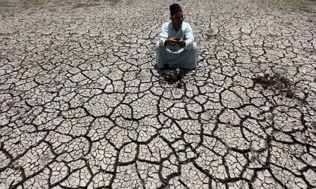
'We woke up in a desert' – the water crisis taking hold across Egypt
Egypt,
once celebrated as the “gift of the Nile”, is in the grips of a
serious water crisis. With a rising population and a fixed supply,
the country has less water per person each year.
The
country’s annual water supply dropped to an average of 660 cubic
metres a person in 2013, down from over 2,500 cubic metres in 1947,
according to official figures. Egypt is already below the United
Nations’ water poverty threshold, and by 2025 the UN predicts it
will be approaching a state of “absolute water crisis”.
Severe rains continue to sweep Florida: The worst flood in the last 65 years hits Tampa
Heavy
rainfall which was continually falling across Tampa,
Florida, since July 20, 2015, has caused severe flooding in the
area. 40 people were evacuated from their mobile homes in Sherwood
Forest RV and Caledesi Travel Trailer Park, on August 3, as the water
levels varied between 91.4 and 122 cm (3 and 4 feet). The Pasco
County Sheriff's Office described the situation as the worst flood in
the last 65 years.
Torrential
rainfalls during the last two weeks were reported to bring over 15.2
cm (half a foot) of water to some areas, closing down about 50
roads in the region. On a few days during thisintensive
rainfall period,
between 50.8 and 76.2 mm (2 and 3 inches) of rain was reported
to have fallen. The amount of recorded precipitation rose to about
102 mm (4 inches) of rain, on Saturday, August 1 and Sunday,
August 2.
72-hr
rainfall accumulation until August 4, 2015 at 15:00 UTC. Image
credit: Google / NASA/JAXA GPM.
Additional
50.8 mm (2 inches) were reported to fall until Monday, August 3, when
the flood warning was in effect for the area until 20:30 UTC. By
early Monday morning, Tampa has
measured over 203 mm (8 inches) of rainfall more than during the
entire average month of August, according to the Weather Channel.
California fires: Evacuation orders given to 13,000
Evacuation
orders have been given to 13,000 people in California as firefighters
struggle to contain some 20 wildfires.
Some
9,000 firefighters worked throughout Monday in steep terrain and
rugged conditions, officials said.
The
biggest blaze - the so-called Rocky fire north of San Francisco - has
already consumed more than 101 square miles (262 sq km) of and.
More
than 3,000 firefighters were employed to fight that specific blaze.
By
Tuesday afternoon, cooler weather helped make a buffer between the
flames and the 5,500 homes they could destroy.
No
additional homes were destroyed on Tuesday, after 24 were burnt down
the day before.
Roosevelt,Wash. under evacuation order due to wildfire
The
entire town of Roosevelt was under mandatory evacuation Tuesday night
after a wildfire jumped State Route 14. Late Tuesday night emergency
dispatchers confirmed that several outbuildings and barns had been
damaged in the fire, however, no homes had been lost.....
Roosevelt
is about 140 miles east of Vancouver.
Heat wave in B.C. breaks 64 temperature records
This
past weekend's heat wave in B.C. is one for the history books.
Environment
Canada says 64 temperature records for communities across the
province have been broken.
The
highest temperature was 40.6 C, recorded in Warfield, a village
outside Trail in West Kootenay, on Saturday.
Osoyoos,
near the U.S. border about 400 kilometres east of Vancouver, came
close — hitting 40.4 C.
The Forest Service just sounded the alarm about dramatically rising wildfire costs

As
14 large fires rage across California, the U.S. Forest Service is
sounding the alarm about the exploding cost of protecting people and
property from a growing wildfire threat.
In
a new report to be released Wednesday, the agency says that while it
spent 16 percent of its total budget on preparing for and fighting
fires in 1995, it will spend more than half its budget this year on
the same task — and a projected 67 percent or more by 2025 under
current funding arrangements.
By
ten years from now, the agency’s expenditures for fighting
wildfires as they flare up—dubbed fire suppression — are
projected to increase from just under $1.1 billion in 2014 to nearly
$1.8 billion. And that’s just one of a number of fire related
costs; there is also an annual, fixed fire “preparedness” budget
that exceeds $1 billion each year.
The
Forest Service report says the agency’s very mission is
“threatened” by this trend of increased fires, which is having a
“debilitating impact” on other Forest Service responsibilities
due to a phenomenon where funds for other priorities get shifted
towards immediate wildfire emergencies.
Flash flooding closes roadways as Calgary pummeled by hail storm
Rain and toonie-sized hail pummeled the City of Calgary and surrounding area on Tuesday afternoon, closing roadways and cutting power to thousands of customers.
The
deputy chief of the Calgary Emergency Management Agency (CEMA) said
911 received six times the average number of calls during the storm.
More than 100 service calls remained for trees that had been downed
on Tuesday night.
A giant sinkhole has opened up in Brooklyn
Police
have blocked off the intersection of Fifth Avenue and 64th Street in
Brooklyn’s Sunset Park as a massive sinkhole has opened up, taking
most of the street corner with it.
MyFoxNY
is reporting that there are no reported injuries from the streets
collapse.
Authorities
are not yet sure if there is any disruption to water or gas services,
but the footage of the sinkhole shows at least one disconnected pipe.
Pictures
posted on twitter show a large hole that could have easily swallowed
up a car. The cave in is limited to the street, and the footpath
remains in tact.
It
isn’t yet clear what caused the sinkhole or if there was any
negligence in maintaining the road that lead to the collapse.
El Niño vs. the Blob: Here's Why California's Drought Probably Won't End Anytime Soon
It'll
take a lot more than one rainy season.
California
could be in for a wetter-than-normal winter, thanks to the mysterious
meteorological phenomenon known as El Niño. Weather scientists have
been watching El Niño get stronger throughout this year and think it
could match or surpass the strongest on record, back in 1997. What
does this mean for long-suffering California and its interminable
drought? Let us explain.
Russia: Plague of locusts descends on Stavropol
World’s glaciers melting at fastest rate since record-keeping began – ‘Globally, we lose about three times the ice volume stored in the entirety of the European Alps every year’


No comments:
Post a Comment
Note: only a member of this blog may post a comment.