Intensifying
Equatorial Rains: 3.3 Million Afflicted by Flooding in India and
Bangladesh as Hundreds Lose Lives to Landslides from Sierra Leone
to Nepal
There’s
something wrong with the rain these days. For many regions of the
globe, when the rain does fall, it more and more often comes with an
abnormally fierce intensity.
This
increasing severity of heavy rainfall events is just one aspect of
human-forced climate change through fossil fuel burning. For as the
Earth warms, both the rate of evaporation and precipitation
increases. And as atmospheric moisture loading and convection
increase coordinate with rising temperatures, so do the potential
peak intensities of the most powerful storms.
(Climate
and extreme weather news August 13 through 15)
Sierra
Leone — More than 300 Dead, 600 Missing After Deadly Mudslide
This
past week, in Sierra Leone — already one of the wettest regions of
the globe at this time of year — a very heavy rainfall event
generated a severe mudslide that ripped a huge swath of devastation
through Freetown. 3,000 people were immediately rendered homeless by
the great rush of mud, rock, and soil. But more tragically in
excess of 300 people are feared deadwith
600 still missing.
This
single event represents the deadliest natural disaster on record for
Sierra Leone — which also suffered a flood that killed 103 people
in 2009. According
to news reports,
the region in which this disaster occurred has experienced 20 inches
more rain than usual over the 30 day period from July 15 through
August 15. A total amount of rainfall in a single month period that’s
now in the range of 50 inches. Clearly, the surrounding lands could
not maintain integrity under the force of such a prolonged deluge.
And unfortunately one of the succumbing hillsides let loose into a
valley settlement.
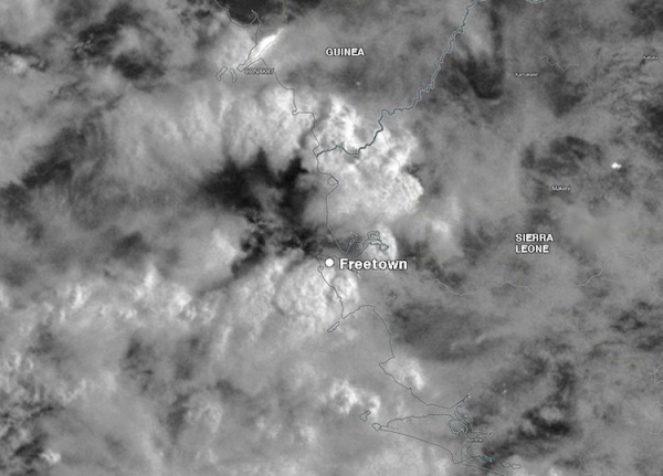
(Heavy
thunderstorms of Freetown on August 14th. Image
source: NASA and Weather
Underground.)
The
heaviest downpours in many parts of the globe have become heavier in
recent decades, a trend attributed to human-produced climate change
and expected to continue. A study led by Christopher Taylor (UK
Centre for Ecology and Hydrology), published
this spring in
the journal Nature, finds that the Sahel’s most intense mesoscale
convective systems (organized clusters of thunderstorms) have tripled
in frequency since 1982. The recovery of Sahel rainfall since the
1980s only explains a small part of this trend, according to the
study authors. They argue that Saharan warming is helping to
intensify convection within the MCSs through increased wind shear and
changes to the Saharan air layer. “The meridional gradient is
projected to strengthen throughout the twenty-first century,
suggesting that the Sahel will experience particularly marked
increases in extreme rain,” the study concludes.
Himachal Pradesh
and Nepal Landslides and Floods Kill Over 100 More
In
India and Bangladesh, 3.3 Million People are Affected by Flooding
In
the Indian state of Assam, 84 people have lost their lives due to a
massive flood that
has now affected 2 million people across 29 districts.
2,734 villages have flooded and 183,584 people have been forced to
relocate to one of 700 refugee camps. Meanwhile, across the state,
some 3,830 water rescues have occurred. Dozens of roads and bridges
have been washed out as rivers rise from moderate to unprecedented
flood stages.
(Assam
floods on August 14. Image source: Government of India
and Floodlist.)
Finally,
in Bangladesh, record rainfall has pushed rivers to some of the
highest levels ever recorded. The result has been the forced
displacement of 368,000 people to 970 temporary shelters as 1.3
million are afflicted by flooding. Tragically, 27 Bangladeshis have
also lost their lives due to the extreme flooding. Rainfall rates of
up to ten inches per day are contributing to the severe flooding even
as water from floods further upstream in India and Nepal are flowing
into Bangladesh river systems.
Conditions
in Context — Very Severe Equatorial Rains
Overall,
these various events may appear to occur separately. However, they
are all associated with a very severe Equatorial rain pattern
developing from Africa through Southeast Asia and stretching into the
Atlantic inter-tropical-convergence zone during 2017. The apparently
increased thunderstorm activity is now impacting everything from the
intensity of monsoonal rains over Southeast Asia, the severity of
storms in the Sahel of Africa, and the early formation of tropical
cyclones off Cape Verde during August.
These
heavy rainfall features are arguably linked to the climate-change
based intensification of the hydrological cycle and, particularly, to
the increasing intensity of Equatorial thunderstorms. The overall
climate and weather trend for the larger region should thus be noted
and these various related events should not be viewed in isolation.
Earthquakes
in Greenland are rare. At least, they’re supposed to be. But a few
weeks ago, a 4.1 “quake” struck Nuugaatsiaq, a tiny island off
Greenland’s west coast, triggering a massive tsunami that smashed
homes, leaving at least four people dead.
One
brave but panicked Greenlander recorded that 17 June incident on
a shaky iPhone.
But
what residents – and seismic equipment – initially labelled a
quake may be nothing of the sort.
“Everyone
was fooled by the collapse of a mountain,” says Martin
Luethi,
a Swiss glaciologist who has been studying Greenland’s glaciers
since 1995. “The tsunami wasn’t triggered by an earthquake.”
Luethi
believes the culprit was a landslide at nearby Karrat fjord. And as
the falling mountain hit the ocean, it created enough seismic noise
to dupe sensors and generate the waves that inundated Nuugaatsiaq.
It’s
a recognised pattern. In 2002, Norwegian
researchers discovered
that landslides can fool seismometers and initiate tsunamis. Two
years earlier,
a landslide triggered a tsunami that levelled the uninhabited mining
town of Qullissat.
“Ice
cannot hold a mountain together if the ice flows,” adds Luethi.
“Melting and freezing cycles mean rocks are getting destroyed.
There’s so much unstable rock in Greenland and they have no
earthquakes to shake it down.”
Aftermath
of the Nuugaatsiaq tsunami
Oline
Nielsen/EPA/REX/Shutterstock
That’s
why there’s such a powder keg brewing, Luethi says. The landslide
in Nuugaatsiaq was
reportedly 1000
metres in length and 300 metres wide. And while the ensuing tsunami
was disastrous, it’s shifting focus from the real problem: this
wasn’t a one-off. This region is full of craggy fjords undergoing
temporal shift. Meaning more so-called quakes – and accompanying
tsunamis – seem imminent.
“All
of these fjords are very steep,” says Martin
Truffer
of the University of Alaska Fairbanks. “If you have loose materials
cemented together with melting ice, there’s potential for more of
these tsunamis.”
Truffer,
a physicist who uses ground-based radar to measure the movement of
glaciers, thinks this is linked to temperature rise. Now he believes
the adjacent mountains are also at risk of eroding and causing
another tsunami.
Locals
aren’t taking any chances. The remaining population of
Nuugaatsiaq has
been evacuated, as
have many nearby communities.
What
determines the severity of these tsunamis? It depends on where these
events occur, and the size of the calved off rock, ice or iceberg
involved.
“Basically,
the deeper the water, the faster the wave,” points out David
Holland,
a New York University professor who studies ice-ocean interaction,
and has tracked Greenland tsunamis that have travelled as fast as
planes. “Five hundred miles per hour. It’s shocking, but there’s
a fair amount of evidence that this happens from time to time.”
So
was this a landslide triggered by an earthquake, or a seismic event
traced to a landslide? The Geological Survey of Denmark and Greenland
are also working to determine the cause. However, Luethi and Truffer,
who between them have nearly 50 years’ experience studying this ice
say the evidence is compelling. A growing contingent
of researchers
online agree.
“If
Greenland continues to warm will there be more incidents like this?”
Truffer wonders before detailing his next step. “Just next to the
landslide, there’s a smaller area that’s looking very unstable.
It looks like it’s warming and creeping down the mountain and
breaking up. That’s the one we’re worried about now. The
destructive power of these things is phenomenal.”
Severe
flooding in Sri Lanka has forced half a million people to flee their
homes across the island nation, officials say, as the death toll from
days of torrential rain and landslides rose to more than 60.
The
toll is likely to rise sharply as authorities battling muddy
conditions begin to give up hope of reaching 132 people believed to
be trapped under the landslides.
"I
don't think there will be any survivors," Major General Sudantha
Ranasinghe, the officer in charge of the rescue operation, told
Reuters.
"There
are places where the mud level is up to 9 metres. We will keep going
until we can recover the maximum."
The
heaviest rains in a quarter of a century have pounded Sri Lanka since
last weekend, ahead of the arrival of the south-west monsoon.
The
worst-hit areas were in Colombo's north-eastern suburbs along the
Kelani river, which began bursting its banks on Thursday evening.
Three
people have been killed in flood-related incidents in Colombo but the
national toll now stands at 64 dead and 29 injured.
The
district of Kegalle, about 100 kilometres north-east of the capital,
has been worst-hit, with the toll from two separate landslides rising
to 34.
Sri
Lanka seeks 'help for victims'
President
Maithripala Sirisena urged people to provide shelter and donate cash
or food as offers of assistance came in from overseas.
"We
have already got some assistance from our friends in the
international community," he said in a televised address.
"Now
I want to ask private individuals, companies and non-governmental
organisations to help in anyway you can to help the victims."
The
national Disaster Management Centre (DMC) said 21 of Sri Lanka's 25
districts had been affected by flooding.
Around
300,000 people had been moved to shelters while a further 200,000
were staying with friends or family.
"Our
information is that about half a million people have been driven out
of their homes," Finance Minister Ravi Karunanayake told
reporters.
The
DMC said tens of thousands of people in the capital, Colombo, were
evacuated in an operation led by the military, involving boats and
helicopters.
Disaster
Management Minister Anura Priyadharshana Yapa said the Government had
sought foreign aid in the form of motors, boats and water purifying
tablet.
India
said it was sending two naval ships and an aircraft loaded with
emergency supplies, including medicine, tents and mobile toilets.
The
torrential rains after months of drought has resulted in severe
floods in May of 2016 in almost 19 administrative districts in Sri
Lanka, hampering the lives of hundreds of thousands. The worst
scenario had been the landslides in the mountain regions where still
many lives are unaccounted for.
Sarvodaya
USA's experience with the 2004 tsunami in Sri Lanka and the 2015
Nepal earthquake has taught us that working with grassroots
organizations can make a critical difference. The best use of
your donation is through people familiar with local needs and
resources.
That's
why Sarvodaya USA is accepting donations for our sister organization
in Sri Lanka, founded by Dr. A.T. Ariyaratne of the Sarvodaya
Shramadana movement of Sri Lanka. Sarvodaya staff and societies
around the country have dedicated their energy to address challenges
and disasters over 50 years of history in Sri Lanka.
Immediately
Mobilizing Relief from 20 District Centers
Sarvodaya,
in partnership with the Voice of Asia Media Network (Siyatha TV and
Siyatha FM) has taken immediate steps to provide relief to the
affected people. Twenty Sarvodaya District Centers are designated for
collection of relief items including water bottles, milk powder, dry
rations, and sanitary items, and the first arrivals are expected by
early morning of Thursday the 19th May.
The
efforts to dispatch the first truck load of potable water to
Pahathgama in Hanwella failed this evening due to inaccessibility of
the site via road. The transitional site has to be reached with 1
kilo meter boat ride after the last point on ground.
Sarvodaya,
along with the Voice of Asia Media Network, appeal the Sri Lankan and
International friends to join with them at this difficult times of
floods 2016.
Providing
relief --food, water, medical treatment and shelter -- is extremely
challenging. Effective long-term reconstruction and support will
require a competent, thoughtful approach.
Please donate
now to help community-led relief and recovery efforts. Every
dollar helps Sri Lankans rebuild Sri Lankan. Your support goes
directly towards families and communities affected by this tragedy.
They
say they are living in fear of flooding and tumbling rock and ice
because they have witnessed cracks in the ground and in glaciers.
Some
glacial lakes have sunk underground with their outlets appearing at
new place.
With
temperatures increasing and the monsoon on the way, anxiety is
rising.
Map
showing glacial lakes in Nepal
Glacial
lakes at risk of flooding following the 25 April earthquake
Hundreds
of people from Sherpa villages fled to higher ground for safety on
Monday night after a small glacial lake burst its banks, sweeping
away two small bridges and a cowshed. It caused rumours that a major
glacial lake had flooded.
line
Sherpas
are members of an ethnic community that descended from Tibet hundreds
of years ago - they use Sherpa as their surnames
A
large number tend to be employed in helping climbers in expeditions
or guiding trekkers, while others run lodges and tea houses for
trekkers and mountaineers
line
Nepal
has more than 2,300 glacial lakes and the most feared is Imja.
Government
officials say a helicopter survey showed Imja was intact, but they
admit a ground study of the area is yet to be done.
Imja
Lake - the most feared - is intact, according to government officials
Locals
say they are relieved about Imja but uncomfortable about other
changes they have observed.
During
a field visit this week a team from Sherpa villages found ice and
debris in a place they should not have been.
"That
was a place where we used to see certain flowers bloom," said
Ang Chiri Sherpa, chairman of the Sagarmatha buffer zone users'
group.
"But
when we went to see what had happened, we saw an unusual, small
glacier-like body of ice and soil and rock debris that could
potentially fall on our village.
"We
have no idea where this potentially dangerous thing came from."
Sherpas
have said new outlets have emerged from glacial lakes
With
the summer season sending temperatures up and monsoon rains
approaching, locals say they are increasingly worried.
"Rising
temperatures mean glacier meltdown will accelerate and rains will
mean moraines [rock and sediment deposited by a glacier] could become
loose," said Tshering Sherpa, an official whose non-governmental
organisation manages Everest base camp and the climbing route to the
highest peak.
"All
these could multiply the risk of outbursts, more so because the
earthquake and continued tremors may have made the moraines of
glacial lakes already weak.
"And
then we have the recent horrifying experience of a lake breaking on
Monday, even if it was a small one."
Most
locals in the villages in the Everest region are still sleeping
outdoors for fear of aftershocks and they say the concern over
possible destabilised glacial lakes and glaciers are making them feel
worse.
Pasang
Sherpa, a lodge owner in Namche said the cries of women and children
on Monday night still ring in her ears.
Sherpas
have found visible cracks following the earthquake and subsequent
aftershocks
"We
were all holding torches and running uphill crying and shouting in
fear, it was miserable."
Scientists
say they have not seen any evidence of risks so far but they also
warn that things could change in these shaky times.
"Except
for this little event of a lake which somehow released all its waters
on Monday, there has been no evidence [of risk] as such," said
Walter Immerzeel, assistant professor of physical geography at
Ultrecht University in the Netherlands.
"But
I think it's a fair concern on the part of Sherpas [because] you have
those moraine dams which block those lakes and they can be
destabilised by earthquakes and aftershocks."
Dr
Immerzeel was in a team that recently produced research on Everest
glaciers published this week in The Cryosphere journal of the
European Geosciences Union (EGU).
"Avalanches
and earthquakes can breach the dams, causing catastrophic floods that
can result in river flows 100 times greater in the Kosi basin,"
the EGU said.
The
Kosi basin stretches from the Everest region in the north to the Kosi
river that joins the Ganges in India across the border in eastern
Nepal.
Although
the government and scientists say they have seen no immediate threat,
members of the Sherpa community argue say their focus has been
limited to the Imja glacial lake.
"So
many other glacial lakes have formed in recent years and none of them
have been studied, all they talk about is Imja," said Ang Chiri
Sherpa.
Rishiram
Sharma, head of the government agency responsible for monitoring and
taking care of the glaciers and glacial lakes in the Nepalese
Himalayas, said his office was trying to co-ordinate with other
government agencies for an urgent field study.
"We
understand the frustration of the Sherpa community and we will
conduct a ground study at the earliest," he said.
The
Sherpas from villages right below the glacial lakes and glaciers say
they have formed a committee to monitor the threat themselves.
"Our
committee will now make a dam to protect a village that was hit by
Monday's flood from a glacial lake and then we will prepare a
database of all the risky glacial lakes including those around the
Khumbu glacier," said Ang Chiri Sherpa.
"We
have heard enough of the government and foreign agencies' plans and
projects to help us."
Previous material on this. The video below is of special interest Risk of Nepal Glacial Lake Outburst
At
least 10,000 people live directly in the path of the three very
unstable glacial lakes, Imja Tsho, Thulagi and Tsho Rolpa. These
areas include the dozens of towns on the main trekking route to Mt
Everest Base Camp. These lakes are extremely vulnerable to
Glacial Lake Outburst Floods (GLOF) from aftershocks following the
7.8 Ricther earthquake on Saturday, 25 April 2015.
GLOFs
occur when earth structures damming large glacial lakes collapse.
Formed out of deposited rocks and mud these dams are inherently
unstable and can be ruptured by a single landslide or avalanche into
the lake. Past floods have obliterated small hydro electric
plants in their path. In 1980 a GLOF in north eastern Nepal
devastated villages over 70km downstream.
The
UN and World Bank have a number of development projects in place to
improve warning systems about GLOFs, but they have not been
adequately successful. Most towns have limited awareness of
these risks and few (if any) have evacuation plans. Due to lack
of resources many of the monitoring systems that did exist have
degraded. The glacier lakes themselves serve as major tourist
attractions, so locals’ incomes rely on remaining in endangered
areas. In fact, as visitor numbers to Mt Everest have increased
significantly over the past ten years, the local population living
the the path of the Imja glacier lake has swelled.
Local
District Disaster Relief Committees generally have very little
knowledge about climate change or GLOF risk management. There
is also insufficient coordination between different agencies for
systematic information sharing on GLOF risk management and no
efficient mechanism for communicating GLOF warnings effectively. UNDP
Report September 2012
The
natural moraine banks that form the dam for these lakes are unstable
and are vulnerable to earthquakes. This instability is
exacerbated by the fact that the volume of the glacial lakes has been
increasing due to climate change.
Government
and disaster management authorities have limited understanding and
experience of managing growing climate risks, including current
variability and the projected impacts of climate change, that are
increasing the range and magnitude of disasters that Nepal is having
to cope with UNDP Report September 2012
As
these lakes only began forming in the late 1950s, they were not a
threat when Nepal last experienced major earthquakes in the 1930s.
Given the volume of water and steep terrain, World Bank flood
models predict walls of water and debris up to 10 metres high,
even 100km from the source.
There is also a chain reaction risk where a comparably small
lake, situated above larger lake, causes a sudden surge of water that
then bursts the larger lake’s moraine dam.
Nouveau
Eco created this risk map (above) because we want people in this zone, both
local and international first responders, to be made aware of the
risks facing them so that they can take steps to prevent further
disaster in this already devastated region.
This same problem was identified in this excellent documentary
Nepal
- I Have Seen the Earth Change
Solukhumbu
is one of the 75 districts in Nepal. It gathers most of the 3300
glaciers and 2300 artic lakes of the country. Inhabitants witness
huge climatic changes in the Everest area. The most striking being
the fast glacier recession, which have given birth to new lakes where
there was only ice and snow. Those lakes are a danger for the
population, natural bombs, ready to explode. If the water overflows,
it will sweep away inhabitants, bridges, houses and villages.
Not
only that, but this
Monsoon
rains increase risks of landslides in Nepal
Nepal
needs to act quickly to reduce the destruction of landslides in
earthquake-affected areas before the monsoon rains arrive, warn
scientists
Nepal
needs to urgently assess the risks from existing and potential
landslides in earthquake affected areas before the monsoon rains
come, say scientists who have produced a detailed map of landslide
risks using satellite data.
The report released
by scientists at the British Geological Survey, Durham University and
University of East Anglia this week says: “The need to plan
measures to mitigate landslide deaths and disruption in the
forthcoming monsoon season must remain a priority. Many more damaging
landslides may occur in the 2015 monsoon, likely to start in late
June, than would be expected if a major earthquake had not occurred.”
The
scientistsidentified at
least six major landslides blocking valleys in areas hit by the 7.8
magnitude earthquake on 25 April. But the team says more major
landslides may be found as more satellite imagery becomes available
(large areas of the region are still obscured by cloud and
dust).
The
risks of landslides will “escalate significantly” as the monsoon
rains begin, the report added. The monsoon that reaches Nepal in
second week of June and withdraws in September brings almost 80% of
the country’s total annual rainfall.
Fresh
landslides will threaten already-affected areas and wash sediment
downstream onto valley floors and floodplains.
Major
landslides are limited to a zone that runs east-west almost parallel
to the transition between the lesser and High Himalaya near the
China-Nepal border.
This zone includes parts of the most affected
districts –Gorkha, Dhading, Nuwakot, Rasuwa, Sindhupalchwok,
Dolakha, Ramechhap and Kavre, where most of the fatalities due to the
earthquake occurred. Major roads to Tibet in the
north and India in the south have also been blocked.
A
team led by the University of Michigan geomorphologist Marin Clark
has also identified tens of thousands of locations at risk of
mudslides and landslides in the mountainous area along the
Nepal-Tibet border, north of Kathmandu and west of Mount Everest.
Image
credit: Dam Hazard ~ University of Michigan
According
to satellite images, avalanches and landslides have blocked the upper
reaches of Buri Gandhaki river in Gorkha district, the Trishuli
river near Thansing and the Sunkoshi river near
Sarsunkharka.
But
this information is not reaching local people. “The district
administration has not informed us about the river blockages. People
are more concerned about procuring plastic sheets right now,” Kapil
Koirala, a resident of Dhulikhel, which lies on the Arniko highway to
Tibet, told thethirdpole.net.
People are scared about the floods and want to move to safer
districts but they don’t know which places are safer, he said.
“The
cloud cover has made it difficult for us to get accurate satellite
pictures and travelling to the areas where landslides have occurred
is not possible right now,” said Narendra Raj Khanal of
ICIMOD. “I have asked for water discharge data and once I have
this I will be in a better position to say how serious the river
blockages could be,” he said.
In
2014 flash floods in Sindhupalchowk district on the Nepal-China
border killed 156 people, after a massive
landslide blockedthe
Sunkoshi River


.JPG)

